FAA INFORMATION EFFECTIVE 22 JANUARY 2026
Location
| FAA Identifier: | LAN |
| Lat/Long: | 42-46-43.1310N 084-35-10.3400W
42-46.718850N 084-35.172333W
42.7786475,-84.5862056
(estimated) |
| Elevation: | 860.5 ft. / 262.3 m (surveyed) |
| Variation: | 05W (1985) |
| From city: | 3 miles NW of LANSING, MI |
| Time zone: | UTC -5 (UTC -4 during Daylight Saving Time) |
| Zip code: | 48906 |
Airport Operations
| Airport use: | Open to the public |
| Activation date: | 04/1940 |
| Control tower: | yes |
| ARTCC: | CLEVELAND CENTER |
| FSS: | LANSING FLIGHT SERVICE STATION |
| NOTAMs facility: | LAN (NOTAM-D service available) |
| Attendance: | CONTINUOUS |
| Wind indicator: | lighted |
| Segmented circle: | no |
| Lights: | SS-SR |
| Beacon: | white-green (lighted land airport)
Operates sunset to sunrise. |
| Fire and rescue: | ARFF index B |
| Airline operations: | ARFF INDEX C & D AVBL ON REQ - CALL ARPT OPS 517-321-8525. |
| International operations: | US CUSTOMS USER FEE ARPT. |
Airport Communications
| UNICOM: | 122.95 |
| ATIS: | 119.75 |
| WX ASOS: | PHONE 517-908-8494 |
| LANSING GROUND: | 121.9 |
| LANSING TOWER: | 119.9 240.9 |
| GREAT LAKES APPROACH: | 118.65 |
| GREAT LAKES DEPARTURE: | 118.65 |
| CLEARANCE DELIVERY: | 123.675 |
| CLASS C: | 118.65 |
| EMERG: | 121.5 |
| WX AWOS-3P at TEW (15 nm SE): | 119.425 (517-676-5607) |
| WX AWOS-3P at FPK (16 nm SW): | 118.075 (517-543-2288) |
- APCH/DEP SVC PRVDD BY CLEVELAND ARTCC (ZOB) ON FREQS 126.75/348.75 (FLINT RCAG) WHEN GREAT LAKES APCH CTL CLSD.
Nearby radio navigation aids
| VOR radial/distance | | VOR name | | Freq | | Var |
|---|
| FNTr259/38.6 | | FLINT VORTAC | | 116.90 | | 06W |
Airport Services
| Fuel available: | 100LL JET-A
100LL:100LL VIA TRUCK ONLY. SELF-SVC NOT AVBL. |
| Parking: | hangars and tiedowns |
| Airframe service: | MAJOR |
| Powerplant service: | MAJOR |
| Bottled oxygen: | NONE |
| Bulk oxygen: | HIGH |
Runway Information
Runway 10R/28L
| Dimensions: | 8506 x 150 ft. / 2593 x 46 m |
| Surface: | asphalt/grooved, in fair condition |
| Weight bearing capacity: | | Single wheel: | 120.0 | | Double wheel: | 217.0 | | Double tandem: | 372.0 | | Dual double tandem: | 861.0 |
|
| Runway edge lights: | high intensity |
| Operational restrictions: | NSTD RWY SAFETY AREA DUE TO SFC VARNS. |
| RUNWAY 10R | | RUNWAY 28L |
| Latitude: | 42-46.692195N | | 42-46.677262N |
| Longitude: | 084-36.063263W | | 084-34.162502W |
| Elevation: | 860.2 ft. | | 848.0 ft. |
| Traffic pattern: | left | | left |
| Runway heading: | 096 magnetic, 091 true | | 276 magnetic, 271 true |
| Declared distances: | TORA:8506 TODA:8506 ASDA:8506 LDA:8506 | | TORA:8506 TODA:8506 ASDA:8506 LDA:8506 |
| Markings: | precision, in fair condition | | precision, in fair condition |
| Visual slope indicator: | 4-light PAPI on left (3.00 degrees glide path) | | 4-light PAPI on right (3.00 degrees glide path) |
| RVR equipment: | touchdown, rollout | | touchdown, rollout |
| Approach lights: | MALSR: 1,400 foot medium intensity approach lighting system with runway alignment indicator lights | | MALSR: 1,400 foot medium intensity approach lighting system with runway alignment indicator lights |
| Runway end identifier lights: | no | | no |
| Touchdown point: | yes, no lights | | yes, no lights |
| Instrument approach: | ILS | | ILS/DME |
Runway 6/24
| Dimensions: | 5003 x 120 ft. / 1525 x 37 m |
| Surface: | asphalt/grooved, in fair condition |
| Weight bearing capacity: | | Single wheel: | 93.0 | | Double wheel: | 117.0 | | Double tandem: | 210.0 |
|
| Runway edge lights: | medium intensity |
| Operational restrictions: | RWY 06/24 NOT AVBL FOR PART 121/PART 380 OPS WITH SKED PAX CARRYING OPS MORE THAN 9 PAX SEATS AND NON-SKED PAX CARRYING OPS MORE THAN 30 PAX SEATS. |
| RUNWAY 6 | | RUNWAY 24 |
| Latitude: | 42-46.390037N | | 42-46.885383N |
| Longitude: | 084-36.062722W | | 084-35.169505W |
| Elevation: | 858.3 ft. | | 847.6 ft. |
| Traffic pattern: | left | | left |
| Runway heading: | 058 magnetic, 053 true | | 238 magnetic, 233 true |
| Declared distances: | TORA:5002 TODA:5002 ASDA:5002 LDA:5002 | | TORA:5002 TODA:5002 ASDA:5002 LDA:5002 |
| Markings: | nonprecision, in fair condition | | nonprecision, in fair condition |
| Visual slope indicator: | 4-light PAPI on left (3.00 degrees glide path) | | 4-light PAPI on left (3.00 degrees glide path) |
| Runway end identifier lights: | yes | | yes |
| Touchdown point: | yes, no lights | | yes, no lights |
| Obstructions: | 42 ft. tree, 950 ft. from runway, 300 ft. right of centerline, 17:1 slope to clear | | 82 ft. trees, 2819 ft. from runway, 417 ft. right of centerline, 31:1 slope to clear |
Runway 10L/28R
| Dimensions: | 3601 x 75 ft. / 1098 x 23 m |
| Surface: | asphalt, in fair condition |
| Weight bearing capacity: | | PCN 70 /F/B/Y/U | | Single wheel: | 12.0 |
|
| Operational restrictions: | RWY 10L/28R NOT AVBL FOR PART 121/PART 380 OPS WITH SKED PAX CARRYING OPS MORE THAN 9 PAX SEATS AND NON-SKED PAX CARRYING OPS MORE THAN 30 PAX SEATS. |
| RUNWAY 10L | | RUNWAY 28R |
| Latitude: | 42-46.915208N | | 42-46.908713N |
| Longitude: | 084-35.098510W | | 084-34.293778W |
| Elevation: | 845.5 ft. | | 850.2 ft. |
| Traffic pattern: | left | | left |
| Runway heading: | 096 magnetic, 091 true | | 276 magnetic, 271 true |
| Declared distances: | TORA:3601 TODA:3601 ASDA:3601 LDA:3601 | | TORA:3601 TODA:3601 ASDA:3601 LDA:3601 |
| Markings: | basic, in good condition | | basic, in good condition |
| Runway end identifier lights: | no | | no |
| Touchdown point: | yes, no lights | | yes, no lights |
| Obstructions: | 77 ft. trees, 2208 ft. from runway, 221 ft. right of centerline, 26:1 slope to clear | | 18 ft. road, 551 ft. from runway, 7 ft. left of centerline, 19:1 slope to clear |
Airport Ownership and Management from official FAA records
| Ownership: | Publicly-owned |
| Owner: | CAPITAL REGION ARPT AUTHORITY
4100 CAPITOL CITY BLVD STE 19
LANSING, MI 48906-2183
Phone 517-321-6121 |
| Manager: | NICOLE NOLL-WILLIAMS
4100 CAPITOL CITY BLVD
LANSING, MI 48906-2170
Phone 517-886-3711 |
Additional Remarks
| A39-06/24 | PCR VALUE: 350/R/B/W/T |
| A39-10R/28L | PCR VALUE: 680/R/B/W/T |
| - | BIRDS ON & INVOF ARPT. |
| - | TWY C SW OF TRANSIENT RAMP NOT AVBL TO ACFT WITH WINGSPAN 90 FT OR GTR. |
| - | TWY G NOT AVBL TO ACFT WITH WINGSPAN 94 FT OR GREATER. |
| - | RWY 06/24 SOUTH OF RWY 10R/28L AVBL TO ACR ACFT FOR TAXI ONLY. |
| - | TWY E & L NOT AVBL TO ACR ACFT. |
| - | RWY 10L/28R CLSD DLY SS-SR. |
| - | WIDE BODY ACFT USE TWYS B OR B1 WHEN EXITING RWY 10R-28L. WIDE BODY ACFT SHOULD USE TWY D WHEN ACESNG THE TRML RAMP. |
| - | PPR FOR ACFT WITH WINGSPAN GTR THAN 170 FT CTC ARPT OPS AT 517-321-8525. |
| - | PAEW ADJ TO MOV AREAS FOR GRASS MOWING OPS APR-NOV. |
| - | RWY 06/24 300 FT SAFETY AREA EACH END. |
| - | INTL ARRIVALS ACCEPTED UP TO 200 PAX. PLEASE CTC CBP FIS AT 517-327-1052 FOR ADDNL INFO. |
| - | USDOT EMERG CONTINGENCY PLAN ON FILE WITH THE ARPT OPS. PLEASE CTC OPS AT 517-321-8525 FOR ADDNL INFO. |
Instrument Procedures
NOTE: All procedures below are presented as PDF files. If you need a reader for these files, you should download the free Adobe Reader.NOT FOR NAVIGATION. Please procure official charts for flight.
FAA instrument procedures published for use from 22 January 2026 at 0901Z to 19 February 2026 at 0900z.
IAPs - Instrument Approach Procedures |
|---|
| ILS OR LOC RWY 10R | |
download (239KB) |
| ILS OR LOC RWY 28L | |
download (241KB) |
| RNAV (GPS) RWY 06 | |
download (231KB) |
| RNAV (GPS) RWY 10R | |
download (250KB) |
| RNAV (GPS) RWY 24 | |
download (229KB) |
| RNAV (GPS) RWY 28L | |
download (206KB) |
| NOTE: Special Alternate Minimums apply | |
download (123KB) |
| NOTE: Special Take-Off Minimums/Departure Procedures apply | |
download |
Other nearby airports with instrument procedures:
4D0 - Abrams Municipal Airport (6 nm W)
KTEW - Mason Jewett Field Airport (15 nm SE)
KFPK - Fitch H Beach Airport (16 nm SW)
Y70 - Ionia County Airport (23 nm NW)
KRNP - Owosso Community Airport (24 nm NE)
|
|

Road maps at:
MapQuest
Bing
Google
| Aerial photo |
|---|
WARNING: Photo may not be current or correct
 Photo by Dick Lawrence
Photo taken 15-May-2017
looking northeast.
Photo by Dick Lawrence
Photo taken 15-May-2017
looking northeast.
Do you have a better or more recent aerial photo of Capital Region International Airport that you would like to share? If so, please send us your photo.
|
| Sectional chart |
|---|
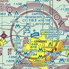
|
 Download PDF
of official airport diagram from the FAA
| Airport distance calculator |
|---|
|
|
| Sunrise and sunset |
|---|
|
Times for 01-Feb-2026
| | Local
(UTC-5) | | Zulu
(UTC) |
|---|
| Morning civil twilight | | 07:24 | | 12:24 |
| Sunrise | | 07:54 | | 12:54 |
| Sunset | | 17:50 | | 22:50 |
| Evening civil twilight | | 18:20 | | 23:20 |
|
| Current date and time |
|---|
| Zulu (UTC) | 01-Feb-2026 06:21:21 |
|---|
| Local (UTC-5) | 01-Feb-2026 01:21:21 |
|---|
|
| METAR |
|---|
| KLAN | 010553Z 00000KT 10SM CLR M19/M22 A3031 RMK AO2 SLP285 I6000 T11891217 11122 21194 58005 $
|
KTEW
15nm SE | 010555Z AUTO 00000KT 10SM CLR M20/M22 A3028 RMK AO2 T12051218 11125 21207 410921207
|
KFPK
16nm SW | 010555Z AUTO 00000KT 10SM CLR M21/M24 A3029 RMK AO2 11147 21228
|
|
| TAF |
|---|
| KLAN | 010520Z 0106/0206 00000KT P6SM SKC FM011800 23006KT P6SM SKC
|
|
| NOTAMs |
|---|
NOTAMs are issued by the DoD/FAA and will open in a separate window not controlled by AirNav.
|
|


