FAA INFORMATION EFFECTIVE 30 OCTOBER 2025
Location
| FAA Identifier: | 4D0 |
| Lat/Long: | 42-46-29.5750N 084-43-59.2910W
42-46.492917N 084-43.988183W
42.7748819,-84.7331364
(estimated) |
| Elevation: | 841.1 ft. / 256.4 m (surveyed) |
| Variation: | 05W (1995) |
| From city: | 2 miles N of GRAND LEDGE, MI |
| Time zone: | UTC -5 (UTC -4 during Daylight Saving Time) |
| Zip code: | 48837 |
Airport Operations
| Airport use: | Open to the public |
| Activation date: | 09/1946 |
| Control tower: | no |
| ARTCC: | CLEVELAND CENTER |
| FSS: | LANSING FLIGHT SERVICE STATION |
| NOTAMs facility: | LAN (NOTAM-D service available) |
| Attendance: | MON&FRI 0800-1630, ALL TUE-THU 0800-0000 |
| Wind indicator: | lighted |
| Segmented circle: | yes |
| Lights: | ACTVT REIL RWY 27; PAPI RWY 09 & 27; MIRL RWY 09/27 - CTAF. |
| Beacon: | white-green (lighted land airport)
Operates sunset to sunrise. |
Airport Communications
| CTAF/UNICOM: | 122.7 |
| GREAT LAKES APPROACH: | 118.65 |
| GREAT LAKES DEPARTURE: | 118.65 |
| WX ASOS at LAN (6 nm E): | PHONE 517-908-8494 |
| WX AWOS-3P at FPK (13 nm S): | 118.075 (517-543-2288) |
| WX AWOS-3 at Y70 (17 nm NW): | 118.9 (616-523-1852) |
| WX AWOS-3P at TEW (19 nm SE): | 119.425 (517-676-5607) |
- APCH/DEP SVC PRVDD BY CLEVELAND ARTCC (ZOB) ON FREQS 126.75/348.75 (FLINT RCAG) WHEN GREAT LAKES APCH CTL CLSD.
Nearby radio navigation aids
| VOR radial/distance | | VOR name | | Freq | | Var |
|---|
| VIOr095/33.6 | | VICTORY VOR/DME | | 115.95 | | 04W |
Airport Services
| Fuel available: | 100LL |
| Parking: | hangars and tiedowns |
| Airframe service: | MAJOR |
| Powerplant service: | MAJOR |
| Bottled oxygen: | NONE |
| Bulk oxygen: | NONE |
Runway Information
Runway 9/27
| Dimensions: | 3200 x 75 ft. / 975 x 23 m |
| Surface: | asphalt, in good condition |
| Runway edge lights: | medium intensity |
| RUNWAY 9 | | RUNWAY 27 |
| Latitude: | 42-46.517055N | | 42-46.557633N |
| Longitude: | 084-44.157673W | | 084-43.444680W |
| Elevation: | 830.5 ft. | | 840.0 ft. |
| Traffic pattern: | left | | left |
| Runway heading: | 091 magnetic, 086 true | | 271 magnetic, 266 true |
| Markings: | nonprecision, in fair condition | | nonprecision, in fair condition |
| Visual slope indicator: | 4-light PAPI on left (4.00 degrees glide path)
UNUSBL BYD 5 DEGS RIGHT OF CNTRLN. | | 2-light PAPI on left (4.00 degrees glide path) |
| Runway end identifier lights: | | | yes |
| Touchdown point: | yes, no lights | | yes, no lights |
| Obstructions: | 49 ft. tree, 1003 ft. from runway, 380 ft. left of centerline, 16:1 slope to clear | | 14 ft. brush, 353 ft. from runway, 204 ft. left of centerline, 10:1 slope to clear
4 FT HILL, 30-199 FT DIST, 125-250 FT L. |
Runway 18/36
| Dimensions: | 2560 x 120 ft. / 780 x 37 m |
| Surface: | turf, in fair condition |
| RUNWAY 18 | | RUNWAY 36 |
| Latitude: | 42-46.648022N | | 42-46.226665N |
| Longitude: | 084-44.220880W | | 084-44.223098W |
| Elevation: | 828.3 ft. | | 836.8 ft. |
| Traffic pattern: | left | | left |
| Runway heading: | 185 magnetic, 180 true | | 005 magnetic, 360 true |
| Displaced threshold: | 388 ft. | | 387 ft. |
| Touchdown point: | yes, no lights | | yes, no lights |
| Obstructions: | 8 ft. trees, 50 ft. from runway, 130 ft. left and right of centerline, 6:1 slope to clear | | 17 ft. road, 45 ft. from runway, 2:1 slope to clear |
Airport Ownership and Management from official FAA records
| Ownership: | Publicly-owned |
| Owner: | CITY OF GRAND LEDGE
310 GREENWOOD ST
GRAND LEDGE, MI 48837-1651
Phone 517-627-2149 |
| Manager: | AMEE KING, ASST CITY MGR
310 GREENWOOD ST
GRAND LEDGE, MI 48837-1651
Phone 517-622-7925 |
Additional Remarks
| - | MILITARY: RNG: NO FIXED WING & LTD ROTARY WING PRKG ON AASF RAMP. |
| - | CTC AIRFIELD OPS ON 41.85/122.7/241.0. |
| - | FOR CD CTC GREAT LAKES APCH AT 269-459-3345, WHEN APCH CLSD CTC CLEVELAND ARTCC AT 440-774-0224/0490. |
| - | TPA 1900 FT MSL FOR FW; 1700 FT MSL FOR HEL. |
| - | DEER & LRG BIRDS ON & INVOF ARPT. |
| - | INTSV NG HELICOPTER TRG ON & INVOF ARPT. HELICOPTERS AVOID FLOW OF FIXED WING ACFT PER 14 CFR 91.126. |
| - | AVOID OVERFLIGHT OF GRAND LEDGE BLW 2000 FT. |
Instrument Procedures
NOTE: All procedures below are presented as PDF files. If you need a reader for these files, you should download the free Adobe Reader.NOT FOR NAVIGATION. Please procure official charts for flight.
FAA instrument procedures published for use from 30 October 2025 at 0901Z to 27 November 2025 at 0900Z.
IAPs - Instrument Approach Procedures |
|---|
| RNAV (GPS) RWY 09 | |
download (186KB) |
| NOTE: Special Take-Off Minimums/Departure Procedures apply | |
download (122KB) |
Other nearby airports with instrument procedures:
KLAN - Capital Region International Airport (6 nm E)
KFPK - Fitch H Beach Airport (13 nm S)
Y70 - Ionia County Airport (17 nm NW)
KTEW - Mason Jewett Field Airport (19 nm SE)
9D9 - Hastings Airport (28 nm W)
|
|

Road maps at:
MapQuest
Bing
Google
| Aerial photo |
|---|
WARNING: Photo may not be current or correct

Do you have a better or more recent aerial photo of Abrams Municipal Airport that you would like to share? If so, please send us your photo.
|
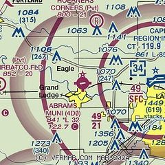
| Sectional chart |
|---|
|
| Airport distance calculator |
|---|
|
|
| Sunrise and sunset |
|---|
|
Times for 15-Nov-2025
| | Local
(UTC-5) | | Zulu
(UTC) |
|---|
| Morning civil twilight | | 07:01 | | 12:01 |
| Sunrise | | 07:32 | | 12:32 |
| Sunset | | 17:15 | | 22:15 |
| Evening civil twilight | | 17:46 | | 22:46 |
|
| Current date and time |
|---|
| Zulu (UTC) | 15-Nov-2025 07:27:57 |
|---|
| Local (UTC-5) | 15-Nov-2025 02:27:57 |
|---|
|
| METAR |
|---|
KLAN
7nm E | 150653Z 13004KT 9SM CLR 08/06 A2976 RMK AO2 SLP080 T00830056
|
KFPK
13nm S | 150655Z AUTO 16003KT 10SM CLR 06/04 A2975 RMK AO2
|
KY70
17nm NW | 150655Z AUTO 17006KT 9SM FEW047 06/04 A2973 RMK AO2
|
KTEW
19nm SE | 150655Z AUTO 18003KT 10SM CLR 09/07 A2976 RMK AO2 T00920069
|
|
| TAF |
|---|
KLAN
7nm E | 150520Z 1506/1606 13003KT P6SM SKC FM151200 21011G19KT P6SM VCSH BKN010 FM151400 22012G24KT P6SM VCSH OVC015 FM151600 24013G25KT P6SM OVC020 FM151900 26014G26KT P6SM OVC022 PROB30 1519/1521 4SM -SHRA OVC015 FM152100 28013G24KT P6SM BKN035
|
|
| NOTAMs |
|---|
NOTAMs are issued by the DoD/FAA and will open in a separate window not controlled by AirNav.
|
|

