FAA INFORMATION EFFECTIVE 16 APRIL 2026
Location
| FAA Identifier: | LIU |
| Lat/Long: | 33-55-26.1991N 102-23-12.0256W
33-55.436652N 102-23.200427W
33.9239442,-102.3866738
(estimated) |
| Elevation: | 3615.6 ft. / 1102.0 m (surveyed) |
| Variation: | 07E (2015) |
| From city: | 3 miles W of LITTLEFIELD, TX |
| Time zone: | UTC -5 (UTC -6 during Standard Time) |
| Zip code: | 79339 |
Airport Operations
| Airport use: | Open to the public |
| Activation date: | 10/1958 |
| Control tower: | no |
| ARTCC: | FORT WORTH CENTER |
| FSS: | FORT WORTH FLIGHT SERVICE STATION |
| NOTAMs facility: | FTW (NOTAM-D service available) |
| Attendance: | 0800-1700 |
| Wind indicator: | lighted |
| Segmented circle: | yes |
| Lights: | SS-SR |
| Beacon: | white-green (lighted land airport)
Operates sunset to sunrise. |
Airport Communications
| CTAF/UNICOM: | 122.8 |
| LUBBOCK APPROACH: | 119.2 119.9 |
| LUBBOCK DEPARTURE: | 119.2 119.9 |
Nearby radio navigation aids
| VOR radial/distance | | VOR name | | Freq | | Var |
|---|
| LBBr288/27.0 | | LUBBOCK VORTAC | | 109.20 | | 11E |
| PVWr241/31.2 | | PLAINVIEW VOR/DME | | 112.90 | | 11E |
Airport Services
| Fuel available: | 100LL
100LL:FOR FUEL AFT HRS CALL 806-777-5030, 806-778-1418 OR 806-241-0761. |
| Parking: | hangars and tiedowns |
| Airframe service: | MINOR |
| Powerplant service: | MINOR |
| Bottled oxygen: | NONE |
| Bulk oxygen: | NONE |
Runway Information
Runway 1/19
| Dimensions: | 4021 x 60 ft. / 1226 x 18 m |
| Surface: | asphalt, in fair condition |
| Weight bearing capacity: | |
| Runway edge lights: | medium intensity |
| RUNWAY 1 | | RUNWAY 19 |
| Latitude: | 33-55.199558N | | 33-55.832555N |
| Longitude: | 102-23.307405W | | 102-23.071467W |
| Elevation: | 3610.7 ft. | | 3608.0 ft. |
| Traffic pattern: | left | | left |
| Runway heading: | 010 magnetic, 017 true | | 190 magnetic, 197 true |
| Markings: | nonprecision, in good condition | | nonprecision, in good condition |
| Visual slope indicator: | 2-light PAPI on left (3.00 degrees glide path) | | 2-light PAPI on left (3.00 degrees glide path) |
| Touchdown point: | yes, no lights | | yes, no lights |
| Obstructions: | 41 ft. tree, 865 ft. from runway, 75 ft. right of centerline, 16:1 slope to clear | | 27 ft. tree, 990 ft. from runway, 222 ft. left of centerline, 29:1 slope to clear |
Runway 13/31
| Dimensions: | 2513 x 40 ft. / 766 x 12 m |
| Surface: | asphalt, in good condition |
| Weight bearing capacity: | |
| RUNWAY 13 | | RUNWAY 31 |
| Latitude: | 33-55.457543N | | 33-55.161662N |
| Longitude: | 102-23.391923W | | 102-23.044090W |
| Elevation: | 3615.6 ft. | | 3606.6 ft. |
| Traffic pattern: | left | | left |
| Runway heading: | 129 magnetic, 136 true | | 309 magnetic, 316 true |
| Markings: | basic, in good condition | | basic, in good condition |
| Touchdown point: | yes, no lights | | yes, no lights |
| Obstructions: | 8 ft. road, 320 ft. from runway, 137 ft. right of centerline, 15:1 slope to clear | | 16 ft. pline, 620 ft. from runway, 145 ft. both sides of centerline, 26:1 slope to clear |
Airport Ownership and Management from official FAA records
| Ownership: | Publicly-owned |
| Owner: | CITY OF LITTLEFIELD
201 XIT DR, BOX 1267
LITTLEFIELD, TX 79339
Phone 806-385-9202 |
| Manager: | TOM BROWN
BOX 1102
LITTLEFIELD, TX 79339
Phone 806-777-5030 |
Additional Remarks
| - | GLIDER OPNS SR-SS WEEKENDS. |
| - | HANGARS OBSTRUCT TRANSITIONAL SFC RWY 13/31. |
| - | FOR CD CTC FORT WORTH ARTCC AT 817-858-7584. |
Instrument Procedures
NOTE: All procedures below are presented as PDF files. If you need a reader for these files, you should download the free Adobe Reader.NOT FOR NAVIGATION. Please procure official charts for flight.
FAA instrument procedures published for use from 16 April 2026 at 0901Z to 14 May 2026 at 0900Z.
IAPs - Instrument Approach Procedures |
|---|
| RNAV (GPS) RWY 01 **CHANGED** | |
download (169KB) |
| NOTE: Special Take-Off Minimums/Departure Procedures apply | |
download (117KB) |
Other nearby airports with instrument procedures:
2T1 - Muleshoe Municipal Airport (20 nm NW)
KLLN - Levelland Municipal Airport (22 nm S)
KLBB - Lubbock Preston Smith International Airport (32 nm SE)
KPVW - Hale County Airport (36 nm NE)
F82 - Lubbock Executive Airpark (39 nm SE)
|
|

Road maps at:
MapQuest
Bing
Google
| Aerial photo |
|---|
WARNING: Photo may not be current or correct

Do you have a better or more recent aerial photo of Littlefield Taylor Brown Municipal Airport that you would like to share? If so, please send us your photo.
|
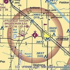
| Sectional chart |
|---|
|
| Airport distance calculator |
|---|
|
|
| Sunrise and sunset |
|---|
|
Times for 23-Apr-2026
| | Local
(UTC-5) | | Zulu
(UTC) |
|---|
| Morning civil twilight | | 06:44 | | 11:44 |
| Sunrise | | 07:10 | | 12:10 |
| Sunset | | 20:26 | | 01:26 |
| Evening civil twilight | | 20:52 | | 01:52 |
|
| Current date and time |
|---|
| Zulu (UTC) | 24-Apr-2026 01:18:48 |
|---|
| Local (UTC-5) | 23-Apr-2026 20:18:48 |
|---|
|
| METAR |
|---|
KLLN
22nm S | 240055Z AUTO 29007KT 10SM CLR 27/M12 A2969 RMK AO2
|
KLBB
32nm SE | 240053Z 28008KT 10SM FEW140 BKN250 29/M07 A2965 RMK AO2 SLP991 T02891072
|
KPVW
36nm NE | 240050Z AUTO 32010KT 10SM CLR 26/M08 A2967 RMK AO2 T02601085
|
|
| TAF |
|---|
KLBB
32nm SE | 232203Z 2322/2418 20011KT P6SM FEW110 BKN250 FM240200 29009KT P6SM SCT150
|
KPVW
36nm NE | 231720Z 2318/2418 26017G27KT P6SM FEW150 FM240200 30009KT P6SM SCT150 AMD NOT SKED
|
|
| NOTAMs |
|---|
NOTAMs are issued by the DoD/FAA and will open in a separate window not controlled by AirNav.
|
|


