FAA INFORMATION EFFECTIVE 14 MAY 2026
Location
| FAA Identifier: | LNL |
| Lat/Long: | 46-09-14.8230N 089-12-43.0740W
46-09.247050N 089-12.717900W
46.1541175,-89.2119650
(estimated) |
| Elevation: | 1705.6 ft. / 519.9 m (surveyed) |
| Variation: | 02W (2000) |
| From city: | 1 mile SE of LAND O' LAKES, WI |
| Time zone: | UTC -5 (UTC -6 during Standard Time) |
| Zip code: | 54540 |
Airport Operations
| Airport use: | Open to the public |
| Activation date: | 12/1941 |
| Control tower: | no |
| ARTCC: | MINNEAPOLIS CENTER |
| FSS: | GREEN BAY FLIGHT SERVICE STATION |
| NOTAMs facility: | LNL (NOTAM-D service available) |
| Attendance: | TUES-SAT 0700-1600 |
| Wind indicator: | lighted |
| Segmented circle: | yes |
| Lights: | ACTVT REIL RWY 14 & 32; PAPI RWY 14 & 32; MIRL RWY 14/32 - CTAF. SS-SR MIRL RWY 14/32 PRESET TO LOW INTST; INCR INTST - CTAF. |
| Beacon: | white-green (lighted land airport)
Operates sunset to sunrise. |
Airport Communications
| CTAF/UNICOM: | 122.8 |
| WX AWOS-3: | 119.525 (715-547-6313) |
| WX AWOS-3 at EGV (14 nm S): | 118.325 (715-479-1465) |
- APCH/DEP SVC PRVDD BY MINNEAPOLIS ARTCC ON FREQS 133.65/281.5 (RHINELANDER RCAG).
Nearby radio navigation aids
| VOR radial/distance | | VOR name | | Freq | | Var |
|---|
| RHIr016/32.9 | | RHINELANDER VOR/DME | | 115.05 | | 02E |
Airport Services
| Fuel available: | 100LL MOGAS
100LL:SELF SVC H24 WITH CREDIT CARD. |
| Parking: | hangars and tiedowns |
| Airframe service: | NONE |
| Powerplant service: | NONE |
| Bottled oxygen: | NONE |
| Bulk oxygen: | NONE |
Runway Information
Runway 14/32
| Dimensions: | 4000 x 75 ft. / 1219 x 23 m |
| Surface: | asphalt, in excellent condition |
| Weight bearing capacity: | |
| Runway edge lights: | medium intensity |
| RUNWAY 14 | | RUNWAY 32 |
| Latitude: | 46-09.513728N | | 46-08.990192N |
| Longitude: | 089-12.998230W | | 089-12.424537W |
| Elevation: | 1705.6 ft. | | 1704.1 ft. |
| Traffic pattern: | left | | left |
| Runway heading: | 145 magnetic, 143 true | | 325 magnetic, 323 true |
| Displaced threshold: | 201 ft. | | 399 ft. |
| Markings: | nonprecision, in good condition | | nonprecision, in good condition |
| Visual slope indicator: | 2-light PAPI on left (4.00 degrees glide path) | | 2-light PAPI on left (3.00 degrees glide path) |
| Runway end identifier lights: | yes | | yes |
| Touchdown point: | yes, no lights | | yes, no lights |
| Obstructions: | 15 ft. road, 200 ft. from runway, 50 ft. left of centerline, 1:1 slope to clear
INTMT USE ROAD 0-200 FT FM RWY END 50-100 FT L. | | 18 ft. road, lighted, 200 ft. from runway, 245 ft. right of centerline, 1:1 slope to clear
ROAD 187 FT FM RWY END 250 FT R. |
Runway 5/23
| Dimensions: | 2577 x 130 ft. / 785 x 40 m |
| Surface: | turf, in fair condition |
| Runway edge markings: | YELLOW CONES. |
| Operational restrictions: | CLSD NOV 15 - APR 15. |
| RUNWAY 5 | | RUNWAY 23 |
| Latitude: | 46-09.103262N | | 46-09.375533N |
| Longitude: | 089-12.961772W | | 089-12.494320W |
| Elevation: | 1696.8 ft. | | 1704.4 ft. |
| Traffic pattern: | left | | left |
| Runway heading: | 052 magnetic, 050 true | | 232 magnetic, 230 true |
| Displaced threshold: | no | | 589 ft. |
| Touchdown point: | yes, no lights | | yes, no lights |
| Obstructions: | 34 ft. trees, 100 ft. left and right of centerline
CTL OBSTN EXCEEDS 45 DEG SLOPE. | | 53 ft. trees, 285 ft. from runway, 120 ft. left of centerline, 5:1 slope to clear
APCH RATIO 16:1 TO DTHR; 94 FT TREES 1490 FT FM DTHR 135 L. |
Airport Ownership and Management from official FAA records
| Ownership: | Publicly-owned |
| Owner: | TOWN OF LAND O'LAKES
BOX 660
LAND O'LAKES, WI 54540
Phone 715-547-3255 |
| Manager: | BRUCE GARRISON
PO BOX 327
LAND O'LAKES, WI 54540
Phone 715-547-3337 |
Additional Remarks
| A30A-14 | APCH RATIO 20:1 TO DTHR. |
| - | DEER ON & INVOF ARPT. |
| - | FOR CD CTC MINNEAPOLIS ARTCC AT 651-463-5588. |
Instrument Procedures
NOTE: All procedures below are presented as PDF files. If you need a reader for these files, you should download the free Adobe Reader.NOT FOR NAVIGATION. Please procure official charts for flight.
FAA instrument procedures published for use from 14 May 2026 at 0901Z to 11 June 2026 at 0900z.
IAPs - Instrument Approach Procedures |
|---|
| RNAV (GPS) RWY 14 | |
download (209KB) |
| RNAV (GPS) RWY 32 | |
download (228KB) |
| NOTE: Special Alternate Minimums apply | |
download (163KB) |
| NOTE: Special Take-Off Minimums/Departure Procedures apply | |
download (469KB) |
Other nearby airports with instrument procedures:
KEGV - Eagle River Union Airport (14 nm S)
KARV - Lakeland Airport/Noble F. Lee Memorial Field (26 nm SW)
D25 - Manitowish Waters Airport (28 nm W)
KRHI - Rhinelander/Oneida County Airport (33 nm S)
Y55 - Crandon/Steve Conway Municipal Airport (40 nm S)
|
|

Road maps at:
MapQuest
Bing
Google
| Aerial photo |
|---|
WARNING: Photo may not be current or correct
 Photo by Jeffrey Patnode
Do you have a better or more recent aerial photo of Kings Land O' Lakes Airport that you would like to share? If so, please send us your photo.
|
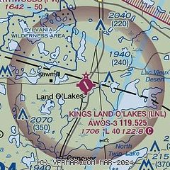
| Sectional chart |
|---|
|
| Airport distance calculator |
|---|
|
|
| Sunrise and sunset |
|---|
|
Times for 14-May-2026
| | Local
(UTC-5) | | Zulu
(UTC) |
|---|
| Morning civil twilight | | 04:51 | | 09:51 |
| Sunrise | | 05:26 | | 10:26 |
| Sunset | | 20:20 | | 01:20 |
| Evening civil twilight | | 20:55 | | 01:55 |
|
| Current date and time |
|---|
| Zulu (UTC) | 15-May-2026 01:35:57 |
|---|
| Local (UTC-5) | 14-May-2026 20:35:57 |
|---|
|
| METAR |
|---|
| KLNL | 150115Z AUTO 18005KT 10SM CLR 17/M02 A2988 RMK AO2 T01701025
|
KEGV
14nm S | 150115Z AUTO 17007KT 10SM CLR 16/M04 A2988 RMK AO2 T01641038
|
|
| TAF |
|---|
KRHI
33nm S | 141723Z 1418/1518 22009G16KT P6SM SCT250 FM150400 18011G19KT P6SM -SHRA BKN060 OVC100 WS020/21035KT FM151000 19012G20KT P6SM OVC035 WS020/22040KT FM151400 20012G22KT P6SM SCT013
|
|
| NOTAMs |
|---|
NOTAMs are issued by the DoD/FAA and will open in a separate window not controlled by AirNav.
|
|

