FAA INFORMATION EFFECTIVE 14 MAY 2026
Location
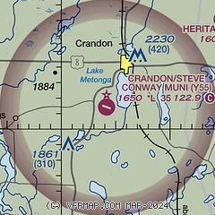
| FAA Identifier: | Y55 |
| Lat/Long: | 45-31-21.5340N 088-55-42.3743W
45-31.358900N 088-55.706238W
45.5226483,-88.9284373
(estimated) |
| Elevation: | 1650 ft. / 502.9 m (surveyed) |
| Variation: | 03W (2015) |
| From city: | 3 miles SW of CRANDON, WI |
| Time zone: | UTC -5 (UTC -6 during Standard Time) |
| Zip code: | 54520 |
Airport Operations
| Airport use: | Open to the public |
| Activation date: | 09/1958 |
| Control tower: | no |
| ARTCC: | MINNEAPOLIS CENTER |
| FSS: | GREEN BAY FLIGHT SERVICE STATION |
| NOTAMs facility: | GRB (NOTAM-D service available) |
| Attendance: | UNATNDD |
| Wind indicator: | lighted |
| Segmented circle: | no |
| Lights: | MIRL RWY 12/30 PRESET TO LOW SS-SR, INCR INTST AND ACTVT - CTAF. |
| Beacon: | white-green (lighted land airport)
Operates sunset to sunrise. |
Airport Communications
- APCH/DEP SVC PRVDD BY MINNEAPOLIS ARTCC ON FREQS 133.65/281.5 (RHINELANDER RCAG).
Nearby radio navigation aids
| VOR radial/distance | | VOR name | | Freq | | Var |
|---|
| RHIr105/23.2 | | RHINELANDER VOR/DME | | 115.05 | | 02E |
Airport Services
| Parking: | tiedowns |
| Airframe service: | NONE |
| Powerplant service: | NONE |
| Bottled oxygen: | NONE |
| Bulk oxygen: | NONE |
Runway Information
Runway 12/30
| Dimensions: | 3550 x 75 ft. / 1082 x 23 m |
| Surface: | asphalt, in fair condition |
| Weight bearing capacity: | |
| Runway edge lights: | medium intensity |
| Runway edge markings: | MARKINGS FADED. |
| RUNWAY 12 | | RUNWAY 30 |
| Latitude: | 45-31.542878N | | 45-31.319537N |
| Longitude: | 088-56.245392W | | 088-55.477553W |
| Elevation: | 1649.8 ft. | | 1627.5 ft. |
| Traffic pattern: | left | | left |
| Markings: | nonprecision, in poor condition | | nonprecision, in poor condition |
| Runway end identifier lights: | no | | no |
| Touchdown point: | yes, no lights | | yes, no lights |
| Obstructions: | none | | 44 ft. trees, marked and lighted, 730 ft. from runway, 300 ft. left of centerline, 12:1 slope to clear |
Runway 1/19
| Dimensions: | 2742 x 100 ft. / 836 x 30 m |
| Surface: | turf, in good condition |
| Runway edge markings: | MKD WITH YELLOW CONES. |
| RUNWAY 1 | | RUNWAY 19 |
| Latitude: | 45-31.041122N | | 45-31.489450N |
| Longitude: | 088-55.541145W | | 088-55.469357W |
| Elevation: | 1614.5 ft. | | 1626.8 ft. |
| Traffic pattern: | left | | left |
| Runway end identifier lights: | no | | no |
| Touchdown point: | yes, no lights | | yes, no lights |
Airport Ownership and Management from official FAA records
| Ownership: | Publicly-owned |
| Owner: | CITY OF CRANDON
601 W. WASHINGTON ST, PO BOX 335
CRANDON, WI 54520
Phone 715-478-2400 |
| Manager: | TIM BAHR
4928 E LAKEVIEW ST
CRANDON, WI 54520
Phone 715-902-0188 |
Additional Remarks
| - | OCNL DEER ON & INVOF ARPT. |
| - | FOR CD CTC MINNEAPOLIS ARTCC AT 651-463-5588. |
Instrument Procedures
NOTE: All procedures below are presented as PDF files. If you need a reader for these files, you should download the free Adobe Reader.NOT FOR NAVIGATION. Please procure official charts for flight.
FAA instrument procedures published for use from 14 May 2026 at 0901Z to 11 June 2026 at 0900Z.
IAPs - Instrument Approach Procedures |
|---|
| RNAV (GPS) RWY 12 | |
download (221KB) |
| RNAV (GPS) RWY 30 | |
download (226KB) |
| NOTE: Special Take-Off Minimums/Departure Procedures apply | |
download (293KB) |
Other nearby airports with instrument procedures:
KAIG - Langlade County Airport (23 nm S)
KRHI - Rhinelander/Oneida County Airport (24 nm W)
KEGV - Eagle River Union Airport (28 nm NW)
KTKV - Tomahawk Regional Airport (37 nm W)
KRRL - Merrill Municipal Airport (38 nm SW)
|
|

Road maps at:
MapQuest
Bing
Google
| Aerial photo |
|---|
WARNING: Photo may not be current or correct
 Photo taken 23-Jul-2006
from a Mooney M20F, at an altitude of 1,500-2,000 AGL
Photo taken 23-Jul-2006
from a Mooney M20F, at an altitude of 1,500-2,000 AGL
Do you have a better or more recent aerial photo of Crandon/Steve Conway Municipal Airport that you would like to share? If so, please send us your photo.
|
| Sectional chart |
|---|
|
| Airport distance calculator |
|---|
|
|
| Sunrise and sunset |
|---|
|
Times for 05-Jun-2026
| | Local
(UTC-5) | | Zulu
(UTC) |
|---|
| Morning civil twilight | | 04:32 | | 09:32 |
| Sunrise | | 05:09 | | 10:09 |
| Sunset | | 20:39 | | 01:39 |
| Evening civil twilight | | 21:16 | | 02:16 |
|
| Current date and time |
|---|
| Zulu (UTC) | 05-Jun-2026 20:26:14 |
|---|
| Local (UTC-5) | 05-Jun-2026 15:26:14 |
|---|
|
| METAR |
|---|
KRHI
24nm W | 051953Z AUTO 23006KT 10SM FEW027 SCT120 24/17 A2979 RMK AO2 RAE1858 SLP081 P0000 T02440172 $
|
KEGV
28nm NW | 052015Z AUTO 22011G18KT 10SM SCT090 BKN120 25/15 A2977 RMK AO2 T02540149
|
KAIG
32nm S | 052015Z AUTO 25010G14KT 10SM SCT042 26/16 A2978 RMK AO2 T02620159
|
KTKV
37nm W | 052015Z AUTO 00000KT 10SM SCT035 SCT040 BKN120 25/17 A2978 RMK AO2 T02540174 PWINO
|
KIMT
38nm NE | 052023Z AUTO 35004KT 9SM -TSRA FEW049 BKN065 OVC100 23/20 A2972 RMK AO2 TSB17 P0000 T02330200
|
KRRL
38nm SW | 052015Z AUTO 24009KT 10SM SCT035 SCT041 26/15 A2976 RMK AO2 T02610147 TSNO
|
KLNL
40nm N | 052015Z AUTO 25006KT 10SM SCT045 SCT060 BKN075 27/15 A2976 RMK AO2 T02700148
|
KARV
41nm NW | 052015Z AUTO 23008G16KT 10SM SCT033 26/16 A2977 RMK AO2 LTG DSNT NW T02620156
|
KAUW
46nm SW | 051954Z AUTO 23007KT 10SM FEW042 27/17 A2977 RMK AO2 SLP078 T02670172
|
KEZS
47nm S | 715-526-2967
052015Z AUTO 24009KT 10SM CLR 29/17 A2976 RMK AO2 LTG DSNT NE T02930166
|
|
| TAF |
|---|
KRHI
24nm W | 051731Z 0518/0618 23006KT P6SM SCT027 FM051900 24006KT P6SM BKN035 FM052100 27005KT P6SM -SHRA BKN045 PROB30 0522/0602 3SM -TSRA BKN025CB FM060200 29002KT P6SM -RA BKN030 FM060500 30002KT P6SM SCT090
|
|
| NOTAMs |
|---|
NOTAMs are issued by the DoD/FAA and will open in a separate window not controlled by AirNav.
|
|

