FAA INFORMATION EFFECTIVE 22 JANUARY 2026
Location
| FAA Identifier: | LNN |
| Lat/Long: | 41-41-02.5000N 081-23-23.1000W
41-41.041667N 081-23.385000W
41.6840278,-81.3897500
(estimated) |
| Elevation: | 625.6 ft. / 190.7 m (surveyed) |
| Variation: | 08W (1995) |
| From city: | 3 miles N of WILLOUGHBY, OH |
| Time zone: | UTC -5 (UTC -4 during Daylight Saving Time) |
| Zip code: | 44094 |
Airport Operations
| Airport use: | Open to the public |
| Activation date: | 12/1937 |
| Control tower: | no |
| ARTCC: | CLEVELAND CENTER |
| FSS: | CLEVELAND FLIGHT SERVICE STATION |
| NOTAMs facility: | LNN (NOTAM-D service available) |
| Attendance: | 0700-2100
FOR ATTENDANT OR FUEL SER AFT HRS CALL 440-942-7092, 2300-0600 BY PRIOR ARNGMT ONLY. |
| Wind indicator: | lighted |
| Segmented circle: | yes |
| Lights: | ACTVT REIL RWY 05, 23, 10, & 28; MIRL RWY 05/23 & 10/28 - CTAF. PAPI RWY 05, 23, 10, & 28 OPR CONSLY. |
| Beacon: | white-green (lighted land airport)
Operates sunset to sunrise. |
| Landing fee: | yes, LDG FEE FOR ALL COML ACFT BY WEIGHT; MULTI-ENG & LRGR. |
Airport Communications
| CTAF/UNICOM: | 122.725 |
| WX AWOS-3PT: | 119.225 (440-942-0809) |
| CLEVELAND APPROACH: | 125.35 |
| CLEVELAND DEPARTURE: | 125.35 |
| BRWNZ STAR: | 126.55 |
| ROKNN STAR: | 126.55 |
| ROLLN STAR: | 126.55 |
| TRYBE STAR: | 126.55 |
| WX AWOS-3PT at CGF (8 nm SW): | PHONE 216-998-7640 |
| WX ASOS at BKL (16 nm SW): | PHONE 216-241-6904 |
Nearby radio navigation aids
| VOR radial/distance | | VOR name | | Freq | | Var |
|---|
| CXRr320/14.3 | | CHARDON VOR/DME | | 112.70 | | 05W |
| ACOr350/35.6 | | AKRON VOR/DME | | 114.40 | | 04W |
| DJBr066/39.8 | | DRYER VOR/DME | | 113.60 | | 05W |
Airport Services
| Fuel available: | 100LL JET-A |
| Parking: | hangars and tiedowns |
| Airframe service: | MAJOR |
| Powerplant service: | MAJOR |
| Bottled oxygen: | NONE |
| Bulk oxygen: | HIGH/LOW |
Runway Information
Runway 5/23
| Dimensions: | 5028 x 100 ft. / 1533 x 30 m |
| Surface: | asphalt, in fair condition |
| Weight bearing capacity: | | Single wheel: | 68.0 | | Double wheel: | 80.0 | | Double tandem: | 124.0 |
|
| Runway edge lights: | medium intensity |
| RUNWAY 5 | | RUNWAY 23 |
| Latitude: | 41-40.825473N | | 41-41.414962N |
| Longitude: | 081-23.846620W | | 081-23.071255W |
| Elevation: | 623.7 ft. | | 619.5 ft. |
| Traffic pattern: | left | | left |
| Runway heading: | 053 magnetic, 045 true | | 233 magnetic, 225 true |
| Displaced threshold: | 428 ft. | | no |
| Markings: | nonprecision, in good condition | | nonprecision, in good condition |
| Visual slope indicator: | 4-light PAPI on left (3.50 degrees glide path) | | 4-light PAPI on left (4.00 degrees glide path) |
| Runway end identifier lights: | yes | | yes |
| Touchdown point: | yes, no lights | | yes, no lights |
| Obstructions: | 62 ft. tree, 1399 ft. from runway, 157 ft. left of centerline, 19:1 slope to clear
APCH SLP 24:1 TO DTHR OVR +98 FT TREE, 2372 FT DIST, 548 FT L. | | 98 ft. trees, 1335 ft. from runway, 341 ft. right of centerline, 11:1 slope to clear |
Runway 10/28
| Dimensions: | 4272 x 100 ft. / 1302 x 30 m |
| Surface: | asphalt, in fair condition |
| Weight bearing capacity: | | Single wheel: | 68.0 | | Double wheel: | 80.0 | | Double tandem: | 124.0 |
|
| Runway edge lights: | medium intensity |
| RUNWAY 10 | | RUNWAY 28 |
| Latitude: | 41-40.951093N | | 41-40.944847N |
| Longitude: | 081-23.767447W | | 081-22.829123W |
| Elevation: | 623.6 ft. | | 624.1 ft. |
| Traffic pattern: | left | | left |
| Runway heading: | 099 magnetic, 091 true | | 279 magnetic, 271 true |
| Displaced threshold: | no | | 1124 ft. |
| Markings: | nonprecision, in good condition | | nonprecision, in good condition |
| Visual slope indicator: | 2-light PAPI on left (3.50 degrees glide path) | | 2-light PAPI on left (3.50 degrees glide path) |
| Runway end identifier lights: | yes | | yes |
| Touchdown point: | yes, no lights | | yes, no lights |
| Obstructions: | none | | 68 ft. trees, 738 ft. from runway, 215 ft. left of centerline, 7:1 slope to clear
APCH SLP 10:1 TO DTHR OVR +89 FT TREES, 931 FT DIST, 329 FT L. |
Airport Ownership and Management from official FAA records
| Ownership: | Publicly-owned |
| Owner: | LAKE DEVELOPMENT AUTHORITY
105 MAIN ST STE B-501
PAINESVILLE, OH 44077-3414
Phone 440-350-5342 |
| Manager: | PATRICK T MOHORCIC
105 MAIN ST STE B-501
PAINESVILLE, OH 44077-3414
Phone 440-350-5343
CELL 440-321-9036. |
Additional Remarks
| - | DEER, BIRDS, & OTR WILDLIFE ON & INVOF ARPT. |
| - | PAT WORK NA 2300-0800. |
| - | FOR CD CTC CLEVELAND APCH AT 216-352-2323. |
Instrument Procedures
NOTE: All procedures below are presented as PDF files. If you need a reader for these files, you should download the free Adobe Reader.NOT FOR NAVIGATION. Please procure official charts for flight.
FAA instrument procedures published for use from 22 January 2026 at 0901Z to 19 February 2026 at 0900z.
STARs - Standard Terminal Arrivals |
|---|
| BRWNZ FOUR (RNAV) | |
2 pages:
[1] [2] (447KB) |
| BRWNZ FOUR (RNAV), CONT.2 | |
download (234KB) |
| ROKNN FOUR (RNAV) | |
2 pages:
[1] [2] (448KB) |
| ROLLN TWO (RNAV) | |
download (344KB) |
| TRYBE FOUR (RNAV) | |
2 pages:
[1] [2] (380KB) |
IAPs - Instrument Approach Procedures |
|---|
| RNAV (GPS) RWY 05 **CHANGED** | |
download (192KB) |
| RNAV (GPS) RWY 10 **CHANGED** | |
download (195KB) |
| RNAV (GPS) RWY 23 **CHANGED** | |
download (219KB) |
| RNAV (GPS) RWY 28 **CHANGED** | |
download (185KB) |
| NOTE: Special Alternate Minimums apply | |
download (168KB) |
Departure Procedures |
|---|
| AHMET FIVE (RNAV) | |
download (224KB) |
| CAVVS FIVE (RNAV) | |
download (213KB) |
| GTLKE FIVE (RNAV) | |
download (268KB) |
| MYCAR FIVE (RNAV) | |
download (205KB) |
| ZAAPA SIX (RNAV) | |
download (239KB) |
| NOTE: Special Take-Off Minimums/Departure Procedures apply | |
download (467KB) |
Other nearby airports with instrument procedures:
KCGF - Cuyahoga County Airport (8 nm SW)
2G1 - Concord Airpark (9 nm E)
KBKL - Burke Lakefront Airport (16 nm SW)
7G8 - Geauga County Airport (20 nm SE)
KCLE - Cleveland-Hopkins International Airport (27 nm SW)
|
|

Road maps at:
MapQuest
Bing
Google
| Aerial photo |
|---|
WARNING: Photo may not be current or correct
 Photo by Brian Matz ~ Aerial Aspect Photography
Photo taken 26-Sep-2013
from an altitude of 4500MSL looking north.
Photo by Brian Matz ~ Aerial Aspect Photography
Photo taken 26-Sep-2013
from an altitude of 4500MSL looking north.
Do you have a better or more recent aerial photo of Lake County Executive Airport that you would like to share? If so, please send us your photo.
|
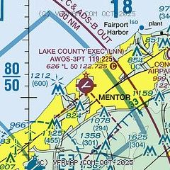
| Sectional chart |
|---|
|
| Airport distance calculator |
|---|
|
|
| Sunrise and sunset |
|---|
|
Times for 11-Feb-2026
| | Local
(UTC-5) | | Zulu
(UTC) |
|---|
| Morning civil twilight | | 06:59 | | 11:59 |
| Sunrise | | 07:27 | | 12:27 |
| Sunset | | 17:52 | | 22:52 |
| Evening civil twilight | | 18:21 | | 23:21 |
|
| Current date and time |
|---|
| Zulu (UTC) | 12-Feb-2026 01:13:26 |
|---|
| Local (UTC-5) | 11-Feb-2026 20:13:26 |
|---|
|
| METAR |
|---|
| KLNN | 120055Z AUTO 00000KT 10SM OVC043 M02/M07 A3015 RMK AO1 T10201075
|
KCGF
8nm SW | 120045Z 32009KT 10SM OVC030 M02/M05 A3013
|
KBKL
15nm SW | 120053Z 30011KT 10SM OVC041 M01/M06 A3015 RMK AO2 SLP214 T10111056
|
|
| NOTAMs |
|---|
NOTAMs are issued by the DoD/FAA and will open in a separate window not controlled by AirNav.
|
|


