FAA INFORMATION EFFECTIVE 22 JANUARY 2026
Location
| FAA Identifier: | LOZ |
| Lat/Long: | 37-05-12.8100N 084-04-38.6160W
37-05.213500N 084-04.643600W
37.0868917,-84.0773933
(estimated) |
| Elevation: | 1212.3 ft. / 369.5 m (surveyed) |
| Variation: | 05W (2005) |
| From city: | 3 miles S of LONDON, KY |
| Time zone: | UTC -5 (UTC -4 during Daylight Saving Time) |
| Zip code: | 40744 |
Airport Operations
| Airport use: | Open to the public |
| Activation date: | 10/1948 |
| Control tower: | no |
| ARTCC: | INDIANAPOLIS CENTER |
| FSS: | LOUISVILLE FLIGHT SERVICE STATION |
| NOTAMs facility: | LOZ (NOTAM-D service available) |
| Attendance: | 0700-1900 |
| Wind indicator: | yes |
| Segmented circle: | yes |
| Lights: | ACTVT REIL RWY 06 & 24; MIRL RWY 06/24 - CTAF. PAPI RWY 06 & 24 OPR CONSLY. |
| Beacon: | white-green (lighted land airport)
Operates sunset to sunrise. |
Airport Communications
| CTAF/UNICOM: | 123.0 |
| WX ASOS: | 119.075 (606-877-1699) |
| WX AWOS-3 at BYL (18 nm S): | 119.575 (606-549-1585) |
- APCH/DEP SVC PRVDD BY INDIANAPOLIS ARTCC ON FREQS 124.625/371.925 (LONDON 2 RCAG).
Nearby radio navigation aids
| VOR radial/distance | | VOR name | | Freq | | Var |
|---|
| LOZr029/3.6 | | LONDON VOR/DME | | 116.55 | | 03W |
Airport Services
| Fuel available: | 100LL JET-A+ |
| Parking: | hangars and tiedowns |
| Airframe service: | MAJOR |
| Powerplant service: | MAJOR |
Runway Information
Runway 6/24
| Dimensions: | 5750 x 150 ft. / 1753 x 46 m |
| Surface: | asphalt, in good condition |
| Weight bearing capacity: | | PCN 23 /F/C/X/T | | Single wheel: | 61.0 | | Double wheel: | 82.0 | | Double tandem: | 151.0 |
|
| Runway edge lights: | medium intensity |
| Operational restrictions: | TREES SW END OF RWY BOTH SIDES VIOLATES 7:1 TRSN SFC. |
| RUNWAY 6 | | RUNWAY 24 |
| Latitude: | 37-04.923895N | | 37-05.503065N |
| Longitude: | 084-05.111483W | | 084-04.175653W |
| Elevation: | 1212.3 ft. | | 1182.7 ft. |
| Traffic pattern: | left | | left |
| Runway heading: | 057 magnetic, 052 true | | 237 magnetic, 232 true |
| Displaced threshold: | 100 ft. | | 548 ft. |
| Declared distances: | TORA:5750 TODA:5750 ASDA:5100 LDA:5000 | | TORA:5750 TODA:5750 ASDA:5750 LDA:5200 |
| Markings: | precision, in good condition | | nonprecision, in good condition |
| Visual slope indicator: | 4-light PAPI on left (3.00 degrees glide path) | | 4-light PAPI on left (4.00 degrees glide path) |
| Runway end identifier lights: | yes
THR LGTS NON STD. | | yes |
| Touchdown point: | yes, no lights | | yes, no lights |
| Instrument approach: | ILS/DME | | |
| Obstructions: | 61 ft. tree, 900 ft. from runway, 610 ft. right of centerline, 11:1 slope to clear
APCH SLOPE 16:1 TO DTHR. | | 29 ft. tree, 292 ft. from runway, 318 ft. right of centerline, 3:1 slope to clear |
Airport Ownership and Management from official FAA records
| Ownership: | Publicly-owned |
| Owner: | CITIES OF LONDON & CORBIN
566 HAL ROGERS DRIVE
LONDON, KY 40744
Phone 606-878-9100 |
| Manager: | MATTHEW SINGER
566 HAL ROGERS DRIVE
LONDON, KY 40744
Phone 606-878-9100 |
Additional Remarks
| - | FOR CD IF UNA TO CTC ON FSS FREQ, CTC INDIANAPOLIS ARTCC AT 317-247-2411. |
Instrument Procedures
NOTE: All procedures below are presented as PDF files. If you need a reader for these files, you should download the free Adobe Reader.NOT FOR NAVIGATION. Please procure official charts for flight.
FAA instrument procedures published for use from 22 January 2026 at 0901Z to 19 February 2026 at 0900z.
IAPs - Instrument Approach Procedures |
|---|
| ILS OR LOC RWY 06 | |
download (238KB) |
| RNAV (GPS) RWY 06 | |
download (263KB) |
| RNAV (GPS) RWY 24 | |
download (244KB) |
| VOR RWY 06 | |
download (216KB) |
| NOTE: Special Alternate Minimums apply | |
download (137KB) |
| NOTE: Special Take-Off Minimums/Departure Procedures apply | |
download (356KB) |
Other nearby airports with instrument procedures:
KBYL - Williamsburg-Whitley County Airport (18 nm S)
KSME - Lake Cumberland Regional Airport (26 nm W)
18I - Mc Creary County Airport (28 nm SW)
1A6 - Middlesboro/Bell County Airport (33 nm SE)
KRGA - Central Kentucky Regional Airport (35 nm N)
|
|

Road maps at:
MapQuest
Bing
Google
| Aerial photo |
|---|
WARNING: Photo may not be current or correct
 Photo by John H Collette
Photo taken 26-Jun-2020
looking north.
Photo by John H Collette
Photo taken 26-Jun-2020
looking north.
Do you have a better or more recent aerial photo of London (Corbin) Magee Airport that you would like to share? If so, please send us your photo.
|
| Sectional chart |
|---|
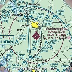
|
| Airport distance calculator |
|---|
|
|
| Sunrise and sunset |
|---|
|
Times for 03-Feb-2026
| | Local
(UTC-5) | | Zulu
(UTC) |
|---|
| Morning civil twilight | | 07:11 | | 12:11 |
| Sunrise | | 07:38 | | 12:38 |
| Sunset | | 18:02 | | 23:02 |
| Evening civil twilight | | 18:29 | | 23:29 |
|
| Current date and time |
|---|
| Zulu (UTC) | 03-Feb-2026 22:29:57 |
|---|
| Local (UTC-5) | 03-Feb-2026 17:29:57 |
|---|
|
| METAR |
|---|
| KLOZ | 032153Z AUTO 00000KT 10SM OVC021 05/01 A3004 RMK AO2 RAB23E42 SLP181 P0000 T00500006
|
KBYL
18nm S | 032215Z AUTO 00000KT 4SM -RA BR FEW034 BKN050 BKN060 03/03 A3005 RMK AO2 P0001 T00310025
|
|
| TAF |
|---|
| KLOZ | 031739Z 0318/0418 VRB03KT P6SM OVC040 FM032000 VRB03KT 6SM -RA OVC025 FM032200 04003KT 3SM -RA BR OVC010 FM040100 04003KT 2SM -RA BR OVC005 FM040800 02004KT 2SM -FZDZSN BR OVC007
|
|
| NOTAMs |
|---|
NOTAMs are issued by the DoD/FAA and will open in a separate window not controlled by AirNav.
|
|

