FAA INFORMATION EFFECTIVE 11 JUNE 2026
Location
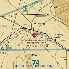
| FAA Identifier: | LSB |
| Lat/Long: | 32-20-01.1640N 108-41-30.6960W
32-20.019400N 108-41.511600W
32.3336567,-108.6918600
(estimated) |
| Elevation: | 4287.9 ft. / 1307.0 m (surveyed) |
| Variation: | 11E (1990) |
| From city: | 1 mile SE of LORDSBURG, NM |
| Time zone: | UTC -6 (UTC -7 during Standard Time) |
| Zip code: | 88045 |
Airport Operations
| Airport use: | Open to the public |
| Activation date: | 12/1938 |
| Control tower: | no |
| ARTCC: | ALBUQUERQUE CENTER |
| FSS: | ALBUQUERQUE FLIGHT SERVICE STATION |
| NOTAMs facility: | ABQ (NOTAM-D service available) |
| Attendance: | 0800-1700 |
| Wind indicator: | lighted |
| Segmented circle: | yes |
| Lights: | ACTVT MIRL RY 12/30 - CTAF. |
| Beacon: | white-green (lighted land airport)
Operates sunset to sunrise. |
Airport Communications
| CTAF/UNICOM: | 122.8 |
| WX AWOS-3PT: | 118.1 (575-542-3549) |
Nearby radio navigation aids
| VOR radial/distance | | VOR name | | Freq | | Var |
|---|
| SSOr069/29.2 | | SAN SIMON VORTAC | | 115.40 | | 13E |
| SVCr223/32.5 | | SILVER CITY VOR/DME | | 115.75 | | 13E |
Airport Services
| Fuel available: | 100LL JET-A1+
100LL:24 HRS SELF SERVE FUEL WITH MAJOR CREDIT CARD. |
| Parking: | hangars and tiedowns |
| Bottled oxygen: | NONE |
| Bulk oxygen: | NONE |
Runway Information
Runway 12/30
| Dimensions: | 5224 x 75 ft. / 1592 x 23 m |
| Surface: | asphalt, in good condition |
| Runway edge lights: | medium intensity |
| RUNWAY 12 | | RUNWAY 30 |
| Latitude: | 32-20.255102N | | 32-19.698238N |
| Longitude: | 108-41.862822W | | 108-41.088757W |
| Elevation: | 4280.4 ft. | | 4276.9 ft. |
| Traffic pattern: | left | | left |
| Runway heading: | 119 magnetic, 130 true | | 299 magnetic, 310 true |
| Markings: | basic, in fair condition | | basic, in fair condition |
| Touchdown point: | yes, no lights | | yes, no lights |
| Obstructions: | none | | 3 ft. brush, 200 ft. from runway, 70 ft. left and right of centerline
2 FT BRUSH IN 30 FT-200 FT FM THR ACRS APCH. |
Runway 1/19
| Dimensions: | 3251 x 60 ft. / 991 x 18 m |
| Surface: | dirt, in fair condition
RWY 1-19 ROUGH SOUTH OF RWY 12-30. |
| RUNWAY 1 | | RUNWAY 19 |
| Latitude: | 32-19.828700N | | 32-20.347370N |
| Longitude: | 108-41.648880W | | 108-41.489435W |
| Elevation: | 4287.9 ft. | | 4255.4 ft. |
| Traffic pattern: | left | | left |
| Runway heading: | 004 magnetic, 015 true | | 184 magnetic, 195 true |
| Markings: | none, in fair condition | | none, in fair condition |
| Touchdown point: | yes, no lights | | yes, no lights |
| Obstructions: | 3 ft. brush, 50 ft. right of centerline
CONTROLLING OBSTRUCTION EXCEEDS A 45 DEGREE SLOPE | | 3 ft. brush, 30 ft. from runway, 55 ft. left and right of centerline, 10:1 slope to clear |
Airport Ownership and Management from official FAA records
| Ownership: | Publicly-owned |
| Owner: | CITY OF LORDSBURG
409 W WABASH
LORDSBURG, NM 88045
Phone 575-542-3421 |
| Manager: | FRITZ PLACENCIA
1000 AIRPORT ROAD
LORDSBURG, NM 88045
Phone 575-542-3614
ALT. PHONE: 575-519-2356. |
Additional Remarks
| - | FOR CD CTC ALBUQUERQUE ARTCC AT 505-856-4861. |
| - | RWY 01/19 THR MARKED WITH REFLECTORS & PAINTED TIRES. |
| - | RWY 12/30, 2-4 FT BRUSH, 75-125 FT SOUTH OF CNTRLN. 2-3 FT SCATTERED BRUSH, 60-125 FT NORTH OF CNTRLN IN PRIMARY SURFACE. |
Instrument Procedures
There are no published instrument procedures at KLSB.
Some nearby airports with instrument procedures:
KSVC - Grant County Airport (33 nm NE)
KCFT - Greenlee County Airport (46 nm NW)
KDMN - Deming Municipal Airport (50 nm E)
KSAD - Safford Regional Airport/1LT Duane Spalsbury Field (57 nm NW)
P33 - Cochise County Airport (61 nm W)
|
|

Road maps at:
MapQuest
Bing
Google
| Aerial photo |
|---|
WARNING: Photo may not be current or correct
 Photo taken 14-Feb-2004
Do you have a better or more recent aerial photo of Lordsburg Municipal Airport that you would like to share? If so, please send us your photo.
|
| Sectional chart |
|---|
|
| Airport distance calculator |
|---|
|
|
| Sunrise and sunset |
|---|
|
Times for 14-Jun-2026
| | Local
(UTC-6) | | Zulu
(UTC) |
|---|
| Morning civil twilight | | 05:40 | | 11:40 |
| Sunrise | | 06:08 | | 12:08 |
| Sunset | | 20:22 | | 02:22 |
| Evening civil twilight | | 20:50 | | 02:50 |
|
| Current date and time |
|---|
| Zulu (UTC) | 15-Jun-2026 05:05:01 |
|---|
| Local (UTC-6) | 14-Jun-2026 23:05:01 |
|---|
|
| METAR |
|---|
| KLSB | 150455Z AUTO 13015G22KT 10SM BKN110 25/13 A3014 RMK AO2
|
|
| TAF |
|---|
KDMN
50nm E | 150405Z 1504/1524 07010KT P6SM VCTS SCT080CB BKN150 FM150900 23006KT P6SM SCT100 BKN200
|
|
| NOTAMs |
|---|
NOTAMs are issued by the DoD/FAA and will open in a separate window not controlled by AirNav.
|
|

