FAA INFORMATION EFFECTIVE 25 DECEMBER 2025
Location
| FAA Identifier: | LWL |
| Lat/Long: | 41-07-01.6000N 114-55-19.7000W
41-07.026667N 114-55.328333W
41.1171111,-114.9221389
(estimated) |
| Elevation: | 5769 ft. / 1758 m (estimated) |
| Variation: | 17E (1975) |
| From city: | 2 miles NE of WELLS, NV |
| Time zone: | UTC -8 (UTC -7 during Daylight Saving Time) |
| Zip code: | 89835 |
Airport Operations
| Airport use: | Open to the public |
| Activation date: | 09/1947 |
| Control tower: | no |
| ARTCC: | SALT LAKE CITY CENTER |
| FSS: | RENO FLIGHT SERVICE STATION |
| NOTAMs facility: | RNO (NOTAM-D service available) |
| Attendance: | UNATNDD |
| Wind indicator: | lighted |
| Segmented circle: | yes |
| Lights: | ACTVT MIRL RWY 09/27 - CTAF. |
| Beacon: | white-green (lighted land airport)
Operates sunset to sunrise. |
Airport Communications
- COMMUNICATIONS PRVDD BY RENO RADIO ON FREQ 122.1R (WELLS RCO).
Nearby radio navigation aids
| VOR radial/distance | | VOR name | | Freq | | Var |
|---|
| LWLr107/3.0 | | WELLS VOR/DME | | 114.65 | | 17E |
Airport Services
| Fuel available: | 100LL JET-A |
| Parking: | tiedowns |
| Bottled oxygen: | NONE |
| Bulk oxygen: | NONE |
Runway Information
Runway 9/27
| Dimensions: | 5508 x 75 ft. / 1679 x 23 m |
| Surface: | asphalt, in good condition |
| Weight bearing capacity: | | Single wheel: | 25.0, CENTER 75 FT STRESSED FOR 25000 LBS SNGL WHEEL; REMAINDER OF 150 FT WIDTH IS 11500 LBS SNGL WHEEL. |
|
| Runway edge lights: | medium intensity |
| RUNWAY 9 | | RUNWAY 27 |
| Latitude: | 41-07.038363N | | 41-06.868307N |
| Longitude: | 114-55.931152W | | 114-54.753585W |
| Elevation: | 5707.2 ft. | | 5769.0 ft. |
| Traffic pattern: | right | | left |
| Runway heading: | 084 magnetic, 101 true | | 264 magnetic, 281 true |
| Markings: | basic, in good condition | | basic, in good condition |
| Runway end identifier lights: | no | | no |
| Touchdown point: | yes, no lights | | yes, no lights |
Runway 1/19
| Dimensions: | 2681 x 140 ft. / 817 x 43 m |
| Surface: | dirt/gravel, in fair condition |
| RUNWAY 1 | | RUNWAY 19 |
| Latitude: | 41-06.979043N | | 41-07.372822N |
| Longitude: | 114-55.429292W | | 114-55.165628W |
| Elevation: | 5733.8 ft. | | 5710.9 ft. |
| Traffic pattern: | right | | left |
| Runway heading: | 010 magnetic, 027 true | | 190 magnetic, 207 true |
| Markings: | none, in fair condition | | none, in fair condition |
| Runway end identifier lights: | no | | no |
| Touchdown point: | yes, no lights | | yes, no lights |
| Obstructions: | 30 ft. bldg, 600 ft. from runway, 300 ft. left of centerline, 20:1 slope to clear | | 11 ft. hill, 300 ft. from runway, 27:1 slope to clear |
Airport Ownership and Management from official FAA records
| Ownership: | Publicly-owned |
| Owner: | CITY OF WELLS
PO BOX 366, 525 SIXTH STREET
WELLS, NV 89835
Phone 775-752-3355 |
| Manager: | JASON PENGELLY
PO BOX 366, 451 UNION STREET
WELLS, NV 89835
Phone 775-752-3355
CITY MGR. |
Additional Remarks
| - | FONE AVBL LCTD AT HNGR. |
| - | RWY 01/19 NO LINE OF SIGHT BETWEEN RWY ENDS. |
| - | MTNS N & S QUADS. |
| - | SNOW REMOVAL SVCS DURG DALGT ONLY EXCP BY PRIOR ARNGMT CALL 775-777-7300. |
| - | ULTRALIGHT ACTVTY ON & INVOF ARPT. |
| - | FIREFIGHTING ACFT ACT ON AND INVOF ARPT. |
| - | USE CTN DRG TKOF AND LND - WIND CIRCULATIONS AND THERMALS IN THE AREA. |
| - | FOR CD IF UNA TO CTC ON FSS FREQ, CTC SALT LAKE ARTCC AT 801-320-2568. |
| - | SEGMENTED CIRC TFC PAT ARMS ARE SCATTERED AND DO NOT REFLECT RIGHT TRAFFIC WHERE DSGND. |
Instrument Procedures
There are no published instrument procedures at KLWL.
Some nearby airports with instrument procedures:
KEKO - Elko Regional Airport (43 nm SW)
KENV - Wendover Airport (47 nm SE)
10U - Owyhee Airport (76 nm NW)
KTWF - Joslin Field/Magic Valley Regional Airport (84 nm N)
KBAM - Battle Mountain Airport (94 nm W)
|
|

Road maps at:
MapQuest
Bing
Google
| Aerial photo |
|---|
WARNING: Photo may not be current or correct
 Photo by Talia Dalton
Photo taken 10-Jul-2008
Photo by Talia Dalton
Photo taken 10-Jul-2008
Do you have a better or more recent aerial photo of Wells Municipal Airport/Harriet Field that you would like to share? If so, please send us your photo.
|
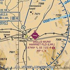
| Sectional chart |
|---|
|
| Airport distance calculator |
|---|
|
|
| Sunrise and sunset |
|---|
|
Times for 03-Jan-2026
| | Local
(UTC-8) | | Zulu
(UTC) |
|---|
| Morning civil twilight | | 06:35 | | 14:35 |
| Sunrise | | 07:06 | | 15:06 |
| Sunset | | 16:22 | | 00:22 |
| Evening civil twilight | | 16:53 | | 00:53 |
|
| Current date and time |
|---|
| Zulu (UTC) | 03-Jan-2026 16:19:22 |
|---|
| Local (UTC-8) | 03-Jan-2026 08:19:22 |
|---|
|
| METAR |
|---|
KEKO
43nm SW | 031556Z AUTO 00000KT 10SM CLR 05/00 A2995 RMK AO2 SLP142 T00500000
|
KENV
48nm SE | 031556Z AUTO 00000KT 10SM CLR 00/M01 A3005 RMK AO2 SLP191 T00001011 FZRANO
|
|
| TAF |
|---|
KEKO
43nm SW | 031133Z 0312/0412 21011KT P6SM SCT200 FM031500 16012G22KT P6SM BKN080 FM032200 18011KT 5SM -RA OVC025 FM040200 22012G22KT P6SM VCSH SCT025 BKN035 FM040900 19009KT P6SM SCT040 BKN200
|
KENV
48nm SE | 031133Z 0312/0412 VRB05KT P6SM SCT120 BKN200 FM040000 VRB03KT P6SM VCSH BKN050 FM040500 10006KT P6SM SCT050 BKN200
|
|
| NOTAMs |
|---|
NOTAMs are issued by the DoD/FAA and will open in a separate window not controlled by AirNav.
|
|

