FAA INFORMATION EFFECTIVE 22 JANUARY 2026
Location
| FAA Identifier: | TWF |
| Lat/Long: | 42-28-54.5130N 114-29-15.8500W
42-28.908550N 114-29.264167W
42.4818092,-114.4877361
(estimated) |
| Elevation: | 4153.4 ft. / 1266.0 m (surveyed) |
| Variation: | 13E (2015) |
| From city: | 4 miles S of TWIN FALLS, ID |
| Time zone: | UTC -7 (UTC -6 during Daylight Saving Time) |
| Zip code: | 83301 |
Airport Operations
| Airport use: | Open to the public |
| Activation date: | 02/1948 |
| Control tower: | yes |
| ARTCC: | SALT LAKE CITY CENTER |
| FSS: | BOISE FLIGHT SERVICE STATION |
| NOTAMs facility: | TWF (NOTAM-D service available) |
| Attendance: | 0630-2000 |
| Wind indicator: | lighted |
| Segmented circle: | yes |
| Lights: | WHEN ATCT CLSD ACTVT MALSR RWY 26; REIL RWY 08; HIRL RWY 08/26 - CTAF. |
| Beacon: | white-green (lighted land airport)
Operates sunset to sunrise. |
| Landing fee: | yes, LNDG FEE FOR FAR PART 121, 135 OPR & GA PART 91 GTR THAN 12500 LB MGLW. |
| Fire and rescue: | ARFF index B |
| Airline operations: | PPR UNSKED ACR OPS GTR THAN 30 PAX SEATS - AMGR. |
Airport Communications
| CTAF: | 118.2 |
| UNICOM: | 122.95 |
| WX ASOS: | 135.025 (208-733-1878) |
| TWIN FALLS GROUND: | 121.7 [0600-2100] |
| TWIN FALLS TOWER: | 118.2 317.5 [0600-2100] |
| TWIN FALLS APPROACH: | 126.7 353.75 [0600-2100] |
| TWIN FALLS DEPARTURE: | 126.7 353.75 [0600-2100] |
| CLEARANCE DELIVERY: | 123.65 |
| WX ASOS at JER (15 nm N): | 135.225 (208-324-7076) |
- APCH/DEP CTL SVC PRVDD BY SALT LAKE ARTCC (ZLC) ON FREQS 118.05/363.0 (BURLEY RCAG) WHEN TWIN FALLS APCH CTL (TWF) CLSD.
Nearby radio navigation aids
| VOR radial/distance | | VOR name | | Freq | | Var |
|---|
| TWF at field | | TWIN FALLS VORTAC | | 113.10 | | 18E |
| BYIr240/28.1 | | BURLEY VOR/DME | | 114.10 | | 18E |
| NDB name | | Hdg/Dist | | Freq | | Var | | ID |
|---|
| STRIK | | 259/5.9 | | 389 | | 13E | | TW | - .-- |
Airport Services
| Fuel available: | 100LL JET-A1+
100LL:SVC FEE 2000-0630; INFO 208-733-5920 OR 539-4034. |
| Parking: | hangars and tiedowns |
| Airframe service: | MAJOR |
| Powerplant service: | MAJOR |
| Bottled oxygen: | HIGH |
| Bulk oxygen: | HIGH |
Runway Information
Runway 8/26
| Dimensions: | 8704 x 150 ft. / 2653 x 46 m |
| Surface: | asphalt/porous friction courses, in good condition |
| Weight bearing capacity: | | Single wheel: | 75.0 | | Double wheel: | 200.0 | | Double tandem: | 250.0 |
|
| Runway edge lights: | high intensity |
| RUNWAY 8 | | RUNWAY 26 |
| Latitude: | 42-28.875738N | | 42-28.842922N |
| Longitude: | 114-30.193340W | | 114-28.258403W |
| Elevation: | 4143.7 ft. | | 4151.5 ft. |
| Traffic pattern: | left | | left |
| Runway heading: | 078 magnetic, 091 true | | 258 magnetic, 271 true |
| Markings: | nonprecision, in good condition | | precision, in good condition |
| Visual slope indicator: | 4-box VASI on left (3.00 degrees glide path) | | 4-light PAPI on left (3.00 degrees glide path) |
| Approach lights: | | | MALSR: 1,400 foot medium intensity approach lighting system with runway alignment indicator lights |
| Runway end identifier lights: | yes | | no |
| Touchdown point: | yes, no lights | | yes, no lights |
| Instrument approach: | | | ILS |
Runway 12/30
| Dimensions: | 3224 x 75 ft. / 983 x 23 m |
| Surface: | asphalt, in fair condition |
| Weight bearing capacity: | |
| Operational restrictions: | NON ACR MOV AREA. |
| RUNWAY 12 | | RUNWAY 30 |
| Latitude: | 42-29.233037N | | 42-28.849413N |
| Longitude: | 114-29.615308W | | 114-29.119895W |
| Elevation: | 4106.7 ft. | | 4147.5 ft. |
| Traffic pattern: | left | | left |
| Runway heading: | 123 magnetic, 136 true | | 303 magnetic, 316 true |
| Markings: | basic, in good condition | | basic, in good condition |
| Runway end identifier lights: | no | | no |
| Touchdown point: | yes, no lights | | yes, no lights |
| Obstructions: | 75 ft. trees, 2000 ft. from runway, 23:1 slope to clear | | none |
Airport Ownership and Management from official FAA records
| Ownership: | Publicly-owned |
| Owner: | CITY OF TWIN FALLS
P.O. BOX 1907
TWIN FALLS, ID 83303
Phone 208-733-5215 |
| Manager: | BILL CARBERRY
P.O. BOX 1907
TWIN FALLS, ID 83303
Phone 208-733-5215 |
Additional Remarks
| A39-12/30 | PCR VALUE: 157/F/B/X/T |
| A39-08/26 | PCR VALUE: 1020/F/B/X/T |
| - | TWY G, H, J & K NON ACR MOV AREA. |
| - | LN OF SIGHT BTN RWY 26 APCH END & RWY 12 APCH END NA. |
| - | FOR CD IF UNA TO CTC ON FSS FREQ, CTC SALT LAKE ARTCC AT 801-320-2568. |
Instrument Procedures
NOTE: All procedures below are presented as PDF files. If you need a reader for these files, you should download the free Adobe Reader.NOT FOR NAVIGATION. Please procure official charts for flight.
FAA instrument procedures published for use from 22 January 2026 at 0901Z to 19 February 2026 at 0900z.
IAPs - Instrument Approach Procedures |
|---|
| ILS OR LOC RWY 26 | |
download (327KB) |
| RNAV (GPS) RWY 08 | |
download (254KB) |
| RNAV (GPS) RWY 26 | |
download (256KB) |
| VOR/DME RWY 08 | |
download (221KB) |
| VOR RWY 08 | |
download (252KB) |
| VOR RWY 26 | |
download (270KB) |
| NOTE: Special Alternate Minimums apply | |
download (211KB) |
Departure Procedures |
|---|
| SNAKO THREE | |
download (249KB) |
| NOTE: Special Take-Off Minimums/Departure Procedures apply | |
download (534KB) |
Other nearby airports with instrument procedures:
KJER - Jerome County Airport (15 nm N)
KGNG - Gooding Municipal Airport (29 nm NW)
KBYI - Burley Municipal Airport (32 nm E)
KSUN - Friedman Memorial Airport (62 nm N)
U76 - Mountain Home Municipal Airport (67 nm NW)
|
|

Road maps at:
MapQuest
Bing
Google
| Aerial photo |
|---|
WARNING: Photo may not be current or correct

Do you have a better or more recent aerial photo of Joslin Field/Magic Valley Regional Airport that you would like to share? If so, please send us your photo.
|
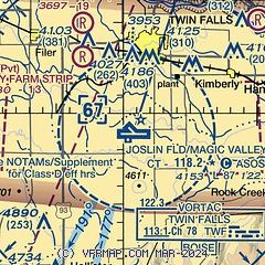
| Sectional chart |
|---|
|
CAUTION: Diagram may not be current
 Download PDF
of official airport diagram from the FAA
| Airport distance calculator |
|---|
|
|
| Sunrise and sunset |
|---|
|
Times for 13-Feb-2026
| | Local
(UTC-7) | | Zulu
(UTC) |
|---|
| Morning civil twilight | | 07:09 | | 14:09 |
| Sunrise | | 07:38 | | 14:38 |
| Sunset | | 18:06 | | 01:06 |
| Evening civil twilight | | 18:35 | | 01:35 |
|
| Current date and time |
|---|
| Zulu (UTC) | 13-Feb-2026 07:27:26 |
|---|
| Local (UTC-7) | 13-Feb-2026 00:27:26 |
|---|
|
| METAR |
|---|
| KTWF | 130653Z AUTO 00000KT 10SM OVC030 03/01 A3021 RMK AO2 SLP228 T00280006 400440022 $
|
KJER
14nm N | 130653Z AUTO 00000KT 10SM OVC032 03/01 A3022 RMK AO2 SLP245 T00280006 400500022
|
|
| TAF |
|---|
| KTWF | 130528Z 1306/1406 VRB06KT P6SM OVC030 FM130800 22006KT 6SM BR SCT005 OVC015 FM132200 30006KT P6SM BKN020 OVC035 FM140100 16005KT P6SM BKN040
|
KJER
14nm N | 130528Z 1306/1406 29005KT P6SM OVC020 FM130900 13005KT 2SM BR VCFG SCT004 OVC015 FM131800 26005KT P6SM OVC020
|
|
| NOTAMs |
|---|
NOTAMs are issued by the DoD/FAA and will open in a separate window not controlled by AirNav.
|
|


