FAA INFORMATION EFFECTIVE 19 MARCH 2026
Location
| FAA Identifier: | BYI |
| Lat/Long: | 42-32-33.4000N 113-46-17.5000W
42-32.556667N 113-46.291667W
42.5426111,-113.7715278
(estimated) |
| Elevation: | 4153.5 ft. / 1266.0 m (surveyed) |
| Variation: | 15E (2000) |
| From city: | 1 mile NE of BURLEY, ID |
| Time zone: | UTC -6 (UTC -7 during Standard Time) |
| Zip code: | 83318 |
Airport Operations
| Airport use: | Open to the public |
| Activation date: | 04/1940 |
| Control tower: | no |
| ARTCC: | SALT LAKE CITY CENTER |
| FSS: | BOISE FLIGHT SERVICE STATION |
| NOTAMs facility: | BYI (NOTAM-D service available) |
| Attendance: | NOV-APR MON-FRI 0800-1700, MAY-OCT 0800-1700, NOV-APR WKENDS ON CALL ONLY 208-678-7118 |
| Wind indicator: | lighted |
| Segmented circle: | no |
| Lights: | ACTVT REIL RWY 20; MIRL RWY 02/20 & 06/24 - CTAF (3 CLICKS TO TURN ON). VASI RWY 02 & 24 OPR CONSLY. |
| Beacon: | white-green (lighted land airport)
Operates sunset to sunrise. |
Airport Communications
| CTAF: | 122.9 |
| WX ASOS: | 135.575 (208-677-3604) |
| TWIN FALLS APPROACH: | 126.7 |
| TWIN FALLS DEPARTURE: | 126.7 |
- APCH/DEP CTL SVC PRVDD BY SALT LAKE ARTCC (ZLC) ON FREQS 118.05/363.0 (BURLEY RCAG) WHEN TWIN FALLS APCH CTL (TWF) CLSD.
- COMMUNICATIONS PRVDD BY BOISE RADIO ON FREQ 122.5 (CONNOR RCO).
Nearby radio navigation aids
| VOR radial/distance | | VOR name | | Freq | | Var |
|---|
| BYIr100/4.7 | | BURLEY VOR/DME | | 114.10 | | 18E |
| TWFr065/32.0 | | TWIN FALLS VORTAC | | 113.10 | | 18E |
Airport Services
| Fuel available: | 100LL JET-A |
| Parking: | tiedowns |
| Airframe service: | MAJOR |
| Powerplant service: | MAJOR |
| Bottled oxygen: | LOW |
| Bulk oxygen: | NONE |
Runway Information
Runway 2/20
| Dimensions: | 4092 x 80 ft. / 1247 x 24 m |
| Surface: | asphalt, in fair condition |
| Weight bearing capacity: | | Single wheel: | 43.0 | | Double wheel: | 60.0 |
|
| Runway edge lights: | medium intensity |
| RUNWAY 2 | | RUNWAY 20 |
| Latitude: | 42-32.259280N | | 42-32.794090N |
| Longitude: | 113-46.443345W | | 113-45.889838W |
| Elevation: | 4153.3 ft. | | 4140.9 ft. |
| Traffic pattern: | left | | left |
| Runway heading: | 022 magnetic, 037 true | | 202 magnetic, 217 true |
| Displaced threshold: | 626 ft. | | 305 ft. |
| Markings: | basic, in good condition | | nonprecision, in good condition |
| Visual slope indicator: | 4-box VASI on left (3.50 degrees glide path) | | |
| Runway end identifier lights: | | | yes |
| Touchdown point: | yes, no lights | | yes, no lights |
| Obstructions: | 20 ft. road, 200 ft. from runway
+15 FT RAIL ROAD SGL 60 FT FM THR AND 160 FT R; +6 FT FENCE 20 FT FM THR ON CNTRLN; +23 FT RAIL ROAD 80 FT FM THR ON CNTRLN. | | 100 ft. stack, 2100 ft. from runway, 40 ft. right of centerline, 19:1 slope to clear
RWY 20 39:1 TO DSPLCD THLD. |
Runway 6/24
| Dimensions: | 4072 x 75 ft. / 1241 x 23 m |
| Surface: | asphalt, in fair condition |
| Weight bearing capacity: | |
| Runway edge lights: | medium intensity |
| RUNWAY 6 | | RUNWAY 24 |
| Latitude: | 42-32.521832N | | 42-32.651158N |
| Longitude: | 113-46.862782W | | 113-45.973410W |
| Elevation: | 4152.9 ft. | | 4142.8 ft. |
| Traffic pattern: | left | | left |
| Runway heading: | 064 magnetic, 079 true | | 244 magnetic, 259 true |
| Displaced threshold: | 796 ft. | | 115 ft. |
| Markings: | basic, in fair condition | | basic, in fair condition |
| Visual slope indicator: | | | 2-box VASI on right (3.00 degrees glide path) |
| Touchdown point: | yes, no lights | | yes, no lights |
| Obstructions: | 27 ft. rr, 200 ft. from runway, 35 ft. left of centerline
23 FT RAIL ROAD 175 FT ON CNTRLN; +8 FT FENCE 0 FT FM THR 80 FT R. | | 32 ft. tree, lighted, 735 ft. from runway, 80 ft. left of centerline, 16:1 slope to clear |
Helipad H1
| Dimensions: | 50 x 50 ft. / 15 x 15 m |
| Surface: | asphalt, in good condition |
| Latitude: | 42-32.372000N | | |
| Longitude: | 113-46.187000W | | |
| Elevation: | 4151.0 ft. | | |
| Traffic pattern: | left | | left |
Airport Ownership and Management from official FAA records
| Ownership: | Publicly-owned |
| Owner: | CITY OF BURLEY
P.O. BOX 1090
BURLEY, ID 83318
Phone 208-878-2224 |
| Manager: | KEVIN GEBHART
P.O. BOX 157
BURLEY, ID 83318
Phone 208-678-0372 |
Additional Remarks
| - | BIRDS INVOF ALL RWYS; ESPECIALLY AER 20 & AER 24. |
| - | RWY 02 & 06; NMRS CLOSE IN OBSTNS. 23 FT HIGH RAIL ROAD BOX CARS MAY BE PRKD ON TRKS OFF END OF RWY 02 & 06. |
| - | MKD HELIPAD ON RAMP IN FRONT OF FBO BLDG. |
| - | AGRICULTURAL ACTIVITY ON AND INVOF ALL RYS APR-OCT. |
| - | FOR CD CTC TWIN FALLS APCH AT 208-734-7160, WHEN APCH CLSD CTC SALT LAKE ARTCC AT 801-320-2568. |
| - | FOR FUEL SALES CTC FBO. NR ON THE FBO DOOR. |
| - | CTN: RWY 2 & 20 - RWY END 20: NMRS 80-120 FT TALL STEAM STACKS LCTD TO THE N OF THE ARPT/SNAKE RIVER AT GEM PROCESSING PLANT; EXER EXTRM CTN ON ARR, SPCLY IN POOR VIS. |
Instrument Procedures
NOTE: All procedures below are presented as PDF files. If you need a reader for these files, you should download the free Adobe Reader.NOT FOR NAVIGATION. Please procure official charts for flight.
FAA instrument procedures published for use from 19 March 2026 at 0901Z to 16 April 2026 at 0900Z.
IAPs - Instrument Approach Procedures |
|---|
| RNAV (GPS) RWY 20 | |
download (275KB) |
| VOR-A | |
download (229KB) |
| NOTE: Special Alternate Minimums apply | |
download (69KB) |
| NOTE: Special Take-Off Minimums/Departure Procedures apply | |
download (223KB) |
Other nearby airports with instrument procedures:
KTWF - Joslin Field/Magic Valley Regional Airport (32 nm W)
KJER - Jerome County Airport (32 nm W)
KGNG - Gooding Municipal Airport (49 nm NW)
KPIH - Pocatello Regional Airport (56 nm NE)
KSUN - Friedman Memorial Airport (62 nm N)
|
|

Road maps at:
MapQuest
Bing
Google
| Aerial photo |
|---|
WARNING: Photo may not be current or correct
 Photo courtesy of GDA Engineers
Photo taken 30-Oct-2013
looking east.
Photo courtesy of GDA Engineers
Photo taken 30-Oct-2013
looking east.
Do you have a better or more recent aerial photo of Burley Municipal Airport that you would like to share? If so, please send us your photo.
|
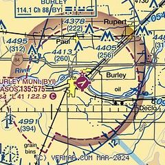
| Sectional chart |
|---|
|
| Airport distance calculator |
|---|
|
|
| Sunrise and sunset |
|---|
|
Times for 28-Mar-2026
| | Local
(UTC-6) | | Zulu
(UTC) |
|---|
| Morning civil twilight | | 06:57 | | 12:57 |
| Sunrise | | 07:25 | | 13:25 |
| Sunset | | 19:55 | | 01:55 |
| Evening civil twilight | | 20:23 | | 02:23 |
|
| Current date and time |
|---|
| Zulu (UTC) | 29-Mar-2026 03:02:28 |
|---|
| Local (UTC-6) | 28-Mar-2026 21:02:28 |
|---|
|
| METAR |
|---|
| KBYI | 290253Z AUTO 27003KT 10SM CLR 15/M06 A2996 RMK AO2 SLP136 T01501056 53002
|
|
| TAF |
|---|
| KBYI | 281720Z 2818/2918 VRB05KT P6SM SCT200 FM281900 27009G18KT P6SM SCT200 FM290300 22006KT P6SM SCT150
|
|
| NOTAMs |
|---|
NOTAMs are issued by the DoD/FAA and will open in a separate window not controlled by AirNav.
|
|

