FAA INFORMATION EFFECTIVE 09 JULY 2026
Location
| FAA Identifier: | MHE |
| Lat/Long: | 43-46-29.3590N 098-02-19.0150W
43-46.489317N 098-02.316917W
43.7748219,-98.0386153
(estimated) |
| Elevation: | 1304.4 ft. / 397.6 m (surveyed) |
| Variation: | 04E (2020) |
| From city: | 3 miles N of MITCHELL, SD |
| Time zone: | UTC -5 (UTC -6 during Standard Time) |
| Zip code: | 57301 |
Airport Operations
| Airport use: | Open to the public |
| Activation date: | 11/1937 |
| Control tower: | no |
| ARTCC: | MINNEAPOLIS CENTER |
| FSS: | HURON FLIGHT SERVICE STATION |
| NOTAMs facility: | MHE (NOTAM-D service available) |
| Attendance: | 0800-1800
FOR ATTENDANT OTHER HRS CALL 605-996-1228. |
| Wind indicator: | lighted |
| Segmented circle: | yes |
| Lights: | ACTVT MALSR RWY 31, REIL RWY 13 & 18, PAPI RWY 13, 31, 18 & 36 , HIRL RWY 13/31; MIRL RWY 18/36 - CTAF. |
| Beacon: | white-green (lighted land airport)
Operates sunset to sunrise. |
Airport Communications
| CTAF/UNICOM: | 122.8 |
| WX ASOS: | 124.175 (605-995-5803) |
- COMMUNICATIONS PRVDD BY HURON RADIO FREQ 122.3 (MITCHELL RCO).
- APCH/DEP SVC PRVDD BY MINNEAPOLIS ARTCC (ZMP) ON FREQ 126.25/339.8 (HURON RCAG).
Nearby radio navigation aids
| VOR radial/distance | | VOR name | | Freq | | Var |
|---|
| MHE at field | | MITCHELL VOR/DME | | 114.15 | | 04E |
Airport Services
| Fuel available: | 100LL JET-A
100LL:FUEL AVBL 24 HRS A DAY. |
| Parking: | hangars and tiedowns |
| Airframe service: | MAJOR |
| Powerplant service: | MAJOR |
| Bottled oxygen: | NONE |
| Bulk oxygen: | NONE |
Runway Information
Runway 13/31
| Dimensions: | 6701 x 100 ft. / 2042 x 30 m |
| Surface: | asphalt, in good condition |
| Weight bearing capacity: | | Single wheel: | 55.0 | | Double wheel: | 90.0 | | Double tandem: | 120.0 |
|
| Runway edge lights: | high intensity |
| RUNWAY 13 | | RUNWAY 31 |
| Latitude: | 43-46.856840N | | 43-46.085070N |
| Longitude: | 098-03.090877W | | 098-02.003705W |
| Elevation: | 1296.1 ft. | | 1303.6 ft. |
| Traffic pattern: | left | | left |
| Runway heading: | 130 magnetic, 134 true | | 310 magnetic, 314 true |
| Markings: | precision, in good condition | | precision, in good condition |
| Visual slope indicator: | 4-light PAPI on left (3.00 degrees glide path) | | 4-light PAPI on left (3.00 degrees glide path) |
| Approach lights: | | | MALSR: 1,400 foot medium intensity approach lighting system with runway alignment indicator lights |
| Runway end identifier lights: | yes | | |
| Touchdown point: | yes, no lights | | yes, no lights |
| Instrument approach: | | | ILS |
Runway 18/36
| Dimensions: | 5513 x 100 ft. / 1680 x 30 m |
| Surface: | asphalt/porous friction courses, in fair condition |
| Weight bearing capacity: | | Single wheel: | 35.0 | | Double wheel: | 90.0 | | Double tandem: | 110.0 |
|
| Runway edge lights: | medium intensity |
| RUNWAY 18 | | RUNWAY 36 |
| Latitude: | 43-46.965262N | | 43-46.057963N |
| Longitude: | 098-02.041782W | | 098-02.032148W |
| Elevation: | 1282.8 ft. | | 1303.0 ft. |
| Traffic pattern: | left | | left |
| Runway heading: | 176 magnetic, 180 true | | 356 magnetic, 360 true |
| Markings: | nonprecision, in fair condition | | nonprecision, in fair condition |
| Visual slope indicator: | 4-light PAPI on left (3.00 degrees glide path) | | 4-light PAPI on left (3.00 degrees glide path) |
| Runway end identifier lights: | yes | | no |
| Touchdown point: | yes, no lights | | yes, no lights |
Airport Ownership and Management from official FAA records
| Ownership: | Publicly-owned |
| Owner: | CITY OF MITCHELL
612 N MAIN ST.
MITCHELL, SD 57301
Phone 605-995-8420 |
| Manager: | DAN LONDON
621 WEST 5TH
MITCHELL, SD 57301
Phone 605-999-7208 |
Additional Remarks
| - | MIGRATORY BIRDS ON & INVOF ARPT. |
| - | ULTRALGT ACTVT ON & INVOF ARPT. |
| - | FOR CD IF UNA TO CTC ON FSS FREQ, CTC MINNEAPOLIS ARTCC AT 651-463-5588. |
Instrument Procedures
NOTE: All procedures below are presented as PDF files. If you need a reader for these files, you should download the free Adobe Reader.NOT FOR NAVIGATION. Please procure official charts for flight.
FAA instrument procedures published for use from 09 July 2026 at 0901Z to 06 August 2026 at 0900Z.
IAPs - Instrument Approach Procedures |
|---|
| ILS OR LOC RWY 31 | |
download (208KB) |
| RNAV (GPS) RWY 13 | |
download (230KB) |
| RNAV (GPS) RWY 18 | |
download (231KB) |
| RNAV (GPS) RWY 31 | |
download (255KB) |
| RNAV (GPS) RWY 36 | |
download (240KB) |
| NOTE: Special Alternate Minimums apply | |
download (176KB) |
| NOTE: Special Take-Off Minimums/Departure Procedures apply | |
download (229KB) |
Other nearby airports with instrument procedures:
8V3 - Parkston Municipal Airport (24 nm S)
4X4 - Wessington Springs Airport (27 nm NW)
KHON - Huron Regional Airport (38 nm N)
KMDS - Madison Municipal Airport (44 nm E)
KAGZ - Wagner Municipal Airport (44 nm S)
|
|

Road maps at:
MapQuest
Bing
Google
| Aerial photo |
|---|
WARNING: Photo may not be current or correct
 Photo by Evan Baas
Photo taken 18-Sep-2019
looking northwest.
Photo by Evan Baas
Photo taken 18-Sep-2019
looking northwest.
Do you have a better or more recent aerial photo of Mitchell Municipal Airport that you would like to share? If so, please send us your photo.
|
| Sectional chart |
|---|
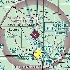
|
| Airport distance calculator |
|---|
|
|
| Sunrise and sunset |
|---|
|
Times for 31-Jul-2026
| | Local
(UTC-5) | | Zulu
(UTC) |
|---|
| Morning civil twilight | | 05:48 | | 10:48 |
| Sunrise | | 06:21 | | 11:21 |
| Sunset | | 20:56 | | 01:56 |
| Evening civil twilight | | 21:29 | | 02:29 |
|
| Current date and time |
|---|
| Zulu (UTC) | 31-Jul-2026 09:34:39 |
|---|
| Local (UTC-5) | 31-Jul-2026 04:34:39 |
|---|
|
| METAR |
|---|
| KMHE | 310853Z AUTO 31018G25KT 10SM OVC007 21/21 A2984 RMK AO2 SLP095 60008 T02110206 55014
|
|
| TAF |
|---|
KHON
37nm N | 310536Z 3106/0106 25009KT 5SM -SHRA BR SCT009 OVC012 FM310900 35012G23KT P6SM SCT015 BKN025 FM311500 02015G26KT P6SM SCT035 FM010100 36010KT P6SM FEW250
|
|
| NOTAMs |
|---|
NOTAMs are issued by the DoD/FAA and will open in a separate window not controlled by AirNav.
|
|


