FAA INFORMATION EFFECTIVE 25 DECEMBER 2025
Location
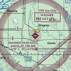
| FAA Identifier: | AGZ |
| Lat/Long: | 43-03-50.9981N 098-17-46.9755W
43-03.849968N 098-17.782925W
43.0641661,-98.2963821
(estimated) |
| Elevation: | 1477.5 ft. / 450.3 m (surveyed) |
| Variation: | 04E (2015) |
| From city: | 1 mile S of WAGNER, SD |
| Time zone: | UTC -6 (UTC -5 during Daylight Saving Time) |
| Zip code: | 57380 |
Airport Operations
| Airport use: | Open to the public |
| Activation date: | 05/1945 |
| Control tower: | no |
| ARTCC: | MINNEAPOLIS CENTER |
| FSS: | HURON FLIGHT SERVICE STATION |
| NOTAMs facility: | HON (NOTAM-D service available) |
| Attendance: | MON-FRI 0700-1700
FOR ATTENDANT AFT HRS CALL 605-487-6262/491-0470. |
| Wind indicator: | lighted |
| Segmented circle: | yes |
| Lights: | MIRL RY 09/27 OPERATE DUSK-0000. AFT 0000 ACTVT - CTAF. |
| Beacon: | white-green (lighted land airport)
Operates sunset to sunrise. |
Airport Communications
| CTAF/UNICOM: | 122.8 |
| WX AWOS-3P: | 128.325 (605-384-3922) |
- AUTOMATED UNICOM.
- APCH/DEP SVC PRVDD BY MINNEAPOLIS ARTCC (ZMP) ON FREQS 128.0/257.95 (O'NEILL RCAG).
Nearby radio navigation aids
| VOR radial/distance | | VOR name | | Freq | | Var |
|---|
| ONLr016/39.6 | | O'NEILL VORTAC | | 113.90 | | 10E |
| NDB name | | Hdg/Dist | | Freq | | Var | | ID |
|---|
| WAGNER | | at field | | 392 | | 08E | | AGZ | .- --. --.. |
Airport Services
| Fuel available: | 100LL |
| Parking: | hangars and tiedowns |
| Airframe service: | MAJOR |
| Powerplant service: | MAJOR |
| Bottled oxygen: | NONE |
| Bulk oxygen: | NONE |
Runway Information
Runway 9/27
| Dimensions: | 3500 x 60 ft. / 1067 x 18 m |
| Surface: | asphalt, in good condition |
| Weight bearing capacity: | |
| Runway edge lights: | medium intensity |
| RUNWAY 9 | | RUNWAY 27 |
| Latitude: | 43-03.914977N | | 43-03.877500N |
| Longitude: | 098-18.229340W | | 098-17.445227W |
| Elevation: | 1477.5 ft. | | 1465.3 ft. |
| Traffic pattern: | left | | left |
| Runway heading: | 090 magnetic, 094 true | | 270 magnetic, 274 true |
| Markings: | nonprecision, in fair condition | | nonprecision, in fair condition |
| Visual slope indicator: | 2-light PAPI on left (3.00 degrees glide path) | | 2-light PAPI on left (3.00 degrees glide path) |
| Runway end identifier lights: | no | | no |
| Touchdown point: | yes, no lights | | yes, no lights |
| Obstructions: | 28 ft. pline, 1205 ft. from runway, 90 ft. left of centerline, 35:1 slope to clear | | 15 ft. road, 620 ft. from runway, 28:1 slope to clear |
Runway 14/32
| Dimensions: | 2252 x 150 ft. / 686 x 46 m |
| Surface: | turf, in good condition |
| Runway edge markings: | MKD WITH BLACK AND W CONES. |
| RUNWAY 14 | | RUNWAY 32 |
| Latitude: | 43-03.934867N | | 43-03.621247N |
| Longitude: | 098-17.833132W | | 098-17.563750W |
| Elevation: | 1467.0 ft. | | 1464.7 ft. |
| Traffic pattern: | left | | left |
| Runway heading: | 144 magnetic, 148 true | | 324 magnetic, 328 true |
| Runway end identifier lights: | no | | no |
| Touchdown point: | yes, no lights | | yes, no lights |
| Obstructions: | 19 ft. road, 470 ft. from runway, 24:1 slope to clear | | 141 ft. pline, 3392 ft. from runway, 24:1 slope to clear |
Airport Ownership and Management from official FAA records
| Ownership: | Publicly-owned |
| Owner: | CITY OF WAGNER
PO BOX 40
WAGNER, SD 57380
Phone 605-384-3741 |
| Manager: | JOHN OTTE
PO BOX 576
WAGNER, SD 57380
Phone 605-384-5858 |
Additional Remarks
| - | SPRAY ACFT OPERATING INVOF ARPT APR-NOV. |
| - | RY 14/32 CLSD 1 NOV-15 APR. |
| - | FOR CD CTC MINNEAPOLIS ARTCC AT 651-463-5588. |
Instrument Procedures
NOTE: All procedures below are presented as PDF files. If you need a reader for these files, you should download the free Adobe Reader.NOT FOR NAVIGATION. Please procure official charts for flight.
FAA instrument procedures published for use from 25 December 2025 at 0901z to 22 January 2026 at 0900z.
IAPs - Instrument Approach Procedures |
|---|
| RNAV (GPS) RWY 09 | |
download (259KB) |
| RNAV (GPS) RWY 27 | |
download (233KB) |
| NOTE: Special Take-Off Minimums/Departure Procedures apply | |
download (164KB) |
Other nearby airports with instrument procedures:
8V3 - Parkston Municipal Airport (23 nm NE)
KONL - The O'Neill Municipal Airport-John L Baker Field (40 nm SW)
6K3 - Creighton Municipal Airport (40 nm SE)
KYKN - Chan Gurney Municipal Airport (41 nm E)
KMHE - Mitchell Municipal Airport (44 nm N)
|
|

Road maps at:
MapQuest
Bing
Google
| Aerial photo |
|---|
WARNING: Photo may not be current or correct
 Photo by Steve Hamilton
Photo taken 07-Nov-2009
Photo by Steve Hamilton
Photo taken 07-Nov-2009
Do you have a better or more recent aerial photo of Wagner Municipal Airport that you would like to share? If so, please send us your photo.
|
| Sectional chart |
|---|
|
| Airport distance calculator |
|---|
|
|
| Sunrise and sunset |
|---|
|
Times for 21-Jan-2026
| | Local
(UTC-6) | | Zulu
(UTC) |
|---|
| Morning civil twilight | | 07:28 | | 13:28 |
| Sunrise | | 07:59 | | 13:59 |
| Sunset | | 17:30 | | 23:30 |
| Evening civil twilight | | 18:01 | | 00:01 |
|
| Current date and time |
|---|
| Zulu (UTC) | 21-Jan-2026 17:46:27 |
|---|
| Local (UTC-6) | 21-Jan-2026 11:46:27 |
|---|
|
| METAR |
|---|
| KAGZ | SuperAWOS
211735Z AUTO 31036G54KT 3SM -RA HZ FEW031 SCT050 SCT070 02/M08 A2995 RMK AO2 PK WND 29054/09 PRESRR
|
|
| NOTAMs |
|---|
NOTAMs are issued by the DoD/FAA and will open in a separate window not controlled by AirNav.
|
|

