FAA INFORMATION EFFECTIVE 19 MARCH 2026
Location
| FAA Identifier: | ONL |
| Lat/Long: | 42-28-09.7000N 098-41-16.0000W
42-28.161667N 098-41.266667W
42.4693611,-98.6877778
(estimated) |
| Elevation: | 2033.7 ft. / 619.9 m (surveyed) |
| Variation: | 09E (1980) |
| From city: | 2 miles NW of O'NEILL, NE |
| Time zone: | UTC -5 (UTC -6 during Standard Time) |
| Zip code: | 68763 |
Airport Operations
| Airport use: | Open to the public |
| Activation date: | 08/1946 |
| Control tower: | no |
| ARTCC: | MINNEAPOLIS CENTER |
| FSS: | COLUMBUS FLIGHT SERVICE STATION |
| NOTAMs facility: | ONL (NOTAM-D service available) |
| Attendance: | CONTINUOUS
FOR AFT HRS SVC CALL 402-336-6582. |
| Wind indicator: | lighted |
| Segmented circle: | yes |
| Lights: | ACTVT REIL RWYS 13 & 31; PAPI RWYS 13 & 31; MIRL RWY 13/31 - CTAF. |
| Beacon: | white-green (lighted land airport)
Operates sunset to sunrise. |
Airport Communications
| CTAF/UNICOM: | 122.8 |
| WX AWOS-3: | 121.125 (402-336-4834) |
- APCH/DEP SVC PRVDD BY MINNEAPOLIS ARTCC ON FREQS 128.0/257.95 (O'NEILL RCAG).
Nearby radio navigation aids
| VOR radial/distance | | VOR name | | Freq | | Var |
|---|
| ONL at field | | O'NEILL VORTAC | | 113.90 | | 10E |
| NDB name | | Hdg/Dist | | Freq | | Var | | ID |
|---|
| WAGNER | | 198/39.7 | | 392 | | 08E | | AGZ | .- --. --.. |
Airport Services
| Fuel available: | 100LL JET-A+ |
| Parking: | hangars and tiedowns |
| Airframe service: | MAJOR |
| Powerplant service: | MAJOR |
| Bottled oxygen: | NONE |
| Bulk oxygen: | NONE |
Runway Information
Runway 13/31
| Dimensions: | 4408 x 75 ft. / 1344 x 23 m |
| Surface: | concrete, in excellent condition |
| Weight bearing capacity: | |
| Runway edge lights: | medium intensity |
| RUNWAY 13 | | RUNWAY 31 |
| Latitude: | 42-28.467053N | | 42-27.920790N |
| Longitude: | 098-41.606395W | | 098-40.961148W |
| Elevation: | 2032.0 ft. | | 2031.7 ft. |
| Traffic pattern: | left | | left |
| Runway heading: | 130 magnetic, 139 true | | 310 magnetic, 319 true |
| Markings: | nonprecision, in good condition | | nonprecision, in good condition |
| Visual slope indicator: | 2-light PAPI on left (3.00 degrees glide path) | | 2-light PAPI on left (3.00 degrees glide path) |
| Runway end identifier lights: | yes | | yes |
| Touchdown point: | yes, no lights | | yes, no lights |
Runway 4/22
| Dimensions: | 3200 x 60 ft. / 975 x 18 m |
| Surface: | concrete |
| RUNWAY 4 | | RUNWAY 22 |
| Latitude: | 42-27.937397N | | 42-28.293070N |
| Longitude: | 098-41.507158W | | 098-40.982340W |
| Elevation: | 2033.5 ft. | | 2029.2 ft. |
| Traffic pattern: | left | | left |
| Runway heading: | 039 magnetic, 048 true | | 219 magnetic, 228 true |
| Markings: | nonprecision, in good condition | | nonprecision, in good condition |
| Touchdown point: | yes, no lights | | yes, no lights |
Airport Ownership and Management from official FAA records
| Ownership: | Publicly-owned |
| Owner: | O'NEILL AIRPORT AUTHORITY
87204 JOHN L. BAKER ROAD
O'NEILL, NE 68763-4614
Phone (402) 336-3377
BARTON BECKER, CHAIRMAN OF ARPT AUTHORITY. |
| Manager: | CORY JOHNSON
87204 JOHN L BAKER ROAD
O'NEILL, NE 68763-4614
Phone 402-760-1232 |
Additional Remarks
| - | WATCH FOR LRG FLOCKS OF WATERFOWL DRG MIGRATION SEASONS (FEBRUARY AND OCTOBER) |
| - | FOR CD IF UNA TO CTC ON FSS FREQ, CTC MINNEAPOLIS ARTCC AT 651-463-5588. |
Instrument Procedures
NOTE: All procedures below are presented as PDF files. If you need a reader for these files, you should download the free Adobe Reader.NOT FOR NAVIGATION. Please procure official charts for flight.
FAA instrument procedures published for use from 19 March 2026 at 0901Z to 16 April 2026 at 0900Z.
IAPs - Instrument Approach Procedures |
|---|
| RNAV (GPS) RWY 13 | |
download (237KB) |
| RNAV (GPS) RWY 31 | |
download (230KB) |
| VOR RWY 13 | |
download (170KB) |
| VOR RWY 31 | |
download (146KB) |
| NOTE: Special Alternate Minimums apply | |
download (140KB) |
| NOTE: Special Take-Off Minimums/Departure Procedures apply | |
download (351KB) |
Other nearby airports with instrument procedures:
8V2 - Stuart-Atkinson Municipal Airport (17 nm W)
6K3 - Creighton Municipal Airport (36 nm E)
4V9 - Antelope County Airport (36 nm SE)
KRBE - Rock County Airport (39 nm W)
KAGZ - Wagner Municipal Airport (40 nm NE)
|
|

Road maps at:
MapQuest
Bing
Google
| Aerial photo |
|---|

|
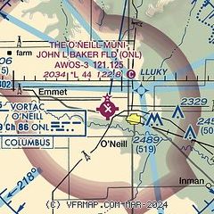
| Sectional chart |
|---|
|
| Airport distance calculator |
|---|
|
|
| Sunrise and sunset |
|---|
|
Times for 13-Apr-2026
| | Local
(UTC-5) | | Zulu
(UTC) |
|---|
| Morning civil twilight | | 06:29 | | 11:29 |
| Sunrise | | 06:58 | | 11:58 |
| Sunset | | 20:13 | | 01:13 |
| Evening civil twilight | | 20:42 | | 01:42 |
|
| Current date and time |
|---|
| Zulu (UTC) | 14-Apr-2026 03:51:33 |
|---|
| Local (UTC-5) | 13-Apr-2026 22:51:33 |
|---|
|
| METAR |
|---|
| KONL | 140335Z AUTO 15003KT 10SM CLR 12/08 A2973 RMK AO2 T01160083
|
|
| NOTAMs |
|---|
NOTAMs are issued by the DoD/FAA and will open in a separate window not controlled by AirNav.
|
|

