FAA INFORMATION EFFECTIVE 11 JUNE 2026
Location
| FAA Identifier: | 4V9 |
| Lat/Long: | 42-06-44.1000N 098-02-23.2000W
42-06.735000N 098-02.386667W
42.1122500,-98.0397778
(estimated) |
| Elevation: | 1773.7 ft. / 540.6 m (surveyed) |
| Variation: | 05E (2010) |
| From city: | 1 mile SW of NELIGH, NE |
| Time zone: | UTC -5 (UTC -6 during Standard Time) |
| Zip code: | 68756 |
Airport Operations
| Airport use: | Open to the public |
| Activation date: | 03/1948 |
| Control tower: | no |
| ARTCC: | MINNEAPOLIS CENTER |
| FSS: | COLUMBUS FLIGHT SERVICE STATION |
| NOTAMs facility: | OLU (NOTAM-D service available) |
| Attendance: | MON-FRI 0800-1700 |
| Wind indicator: | lighted |
| Segmented circle: | no |
| Lights: | ACTVT PAPI RY 01/19; MIRL RY 01/19 - CTAF; AFT 2000 ACTVT MIRL RY 13/31 - CTAF. |
| Beacon: | white-green (lighted land airport)
Operates sunset to sunrise. |
Airport Communications
| CTAF/UNICOM: | 122.8 |
| WX AWOS-3PT: | 119.275 (402-887-5233) |
- APCH/DEP SVC PRVDD BY MINNEAPOLIS ARTCC ON FREQS 128.0/257.95 (O'NEILL RCAG).
Nearby radio navigation aids
| VOR radial/distance | | VOR name | | Freq | | Var |
|---|
| OFKr277/28.0 | | NORFOLK VOR/DME | | 114.35 | | 08E |
| ONLr117/35.9 | | O'NEILL VORTAC | | 113.90 | | 10E |
Airport Services
| Fuel available: | 100LL |
| Parking: | hangars and tiedowns |
| Airframe service: | NONE |
| Powerplant service: | NONE |
| Bottled oxygen: | NONE |
| Bulk oxygen: | NONE |
Runway Information
Runway 1/19
| Dimensions: | 3700 x 60 ft. / 1128 x 18 m |
| Surface: | concrete, in good condition |
| Runway edge lights: | medium intensity |
| RUNWAY 1 | | RUNWAY 19 |
| Latitude: | 42-06.309400N | | 42-06.903965N |
| Longitude: | 098-02.446545W | | 098-02.268672W |
| Elevation: | 1773.7 ft. | | 1731.3 ft. |
| Traffic pattern: | left | | left |
| Runway heading: | 008 magnetic, 013 true | | 188 magnetic, 193 true |
| Markings: | nonprecision, in good condition | | nonprecision, in good condition |
| Visual slope indicator: | 2-light PAPI on left (3.00 degrees glide path) | | 2-light PAPI on left (3.50 degrees glide path) |
| Touchdown point: | yes, no lights | | yes, no lights |
Runway 13/31
| Dimensions: | 3310 x 60 ft. / 1009 x 18 m |
| Surface: | concrete, in good condition |
| Weight bearing capacity: | |
| Runway edge lights: | medium intensity |
| RUNWAY 13 | | RUNWAY 31 |
| Latitude: | 42-07.068057N | | 42-06.686152N |
| Longitude: | 098-02.678397W | | 098-02.156188W |
| Elevation: | 1735.1 ft. | | 1729.7 ft. |
| Traffic pattern: | left | | left |
| Runway heading: | 129 magnetic, 134 true | | 309 magnetic, 314 true |
| Displaced threshold: | 405 ft. | | 405 ft. |
| Declared distances: | TORA:3310 TODA:3310 ASDA:3310 LDA:2905 | | TORA:3310 TODA:3310 ASDA:3310 LDA:2905 |
| Markings: | basic, in good condition | | basic, in good condition |
| Touchdown point: | yes, no lights | | yes, no lights |
| Obstructions: | 16 ft. road, 239 ft. from runway, 2:1 slope to clear
RWY 13 6 FT FENCE 200 FT FM END, 90 FT R CONTN S. | | 10 ft. road, 201 ft. from runway, 1:1 slope to clear
RWY 31 ROAD 169 FT FM END 89 FT R. |
Airport Ownership and Management from official FAA records
| Ownership: | Publicly-owned |
| Owner: | ANTELOPE CO ARPT AUTH
84773 AIRPORT RD
NELIGH, NE 68756-5001
Phone 402-887-4827 |
| Manager: | 05001-5001
ADDNL CTC: BRIAN WHITESEL 402-649-4172 OR JOE MCNALLY 402-650-2520. AUTHORITY CHAIRMAN IS RICK SCHINDLER, SAME CONTACT INFO AS OWNER |
Additional Remarks
| - | UNICOM UNMON. |
| - | FOR CD CTC MINNEAPOLIS ARTCC AT 651-463-5588. |
| - | COURTESY CAR AVBL. |
Instrument Procedures
NOTE: All procedures below are presented as PDF files. If you need a reader for these files, you should download the free Adobe Reader.NOT FOR NAVIGATION. Please procure official charts for flight.
FAA instrument procedures published for use from 11 June 2026 at 0901Z to 09 July 2026 at 0900z.
IAPs - Instrument Approach Procedures |
|---|
| RNAV (GPS) RWY 01 | |
download (239KB) |
| RNAV (GPS) RWY 19 | |
download (202KB) |
| NOTE: Special Alternate Minimums apply | |
download (147KB) |
| NOTE: Special Take-Off Minimums/Departure Procedures apply | |
download (147KB) |
Other nearby airports with instrument procedures:
6K3 - Creighton Municipal Airport (23 nm N)
KBVN - Albion Municipal Airport (23 nm S)
KOFK - Norfolk Regional Airport/Karl Stefan Memorial Field (28 nm E)
KONL - The O'Neill Municipal Airport-John L Baker Field (36 nm NW)
0B4 - Hartington Municipal Airport/Bud Becker Field (46 nm NE)
|
|

Road maps at:
MapQuest
Bing
Google
| Aerial photo |
|---|
WARNING: Photo may not be current or correct
 Photo by William Maxey
Photo taken 22-Jul-2007
Photo by William Maxey
Photo taken 22-Jul-2007
Do you have a better or more recent aerial photo of Antelope County Airport that you would like to share? If so, please send us your photo.
|
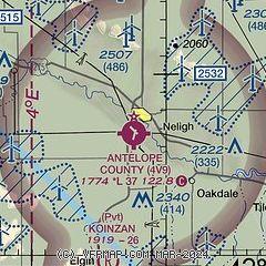
| Sectional chart |
|---|
|
| Airport distance calculator |
|---|
|
|
| Sunrise and sunset |
|---|
|
Times for 17-Jun-2026
| | Local
(UTC-5) | | Zulu
(UTC) |
|---|
| Morning civil twilight | | 05:22 | | 10:22 |
| Sunrise | | 05:57 | | 10:57 |
| Sunset | | 21:09 | | 02:09 |
| Evening civil twilight | | 21:44 | | 02:44 |
|
| Current date and time |
|---|
| Zulu (UTC) | 17-Jun-2026 12:10:59 |
|---|
| Local (UTC-5) | 17-Jun-2026 07:10:59 |
|---|
|
| METAR |
|---|
KBVN
23nm S | 171155Z AUTO 05006KT 10SM CLR 19/15 A2939 RMK AO2 T01860147 10215 20186
|
KOFK
28nm E | 171156Z AUTO 12007KT 10SM CLR 20/16 A2937 RMK AO2 SLP930 T02000156 10222 20200 51021
|
KONL
35nm NW | 171155Z AUTO 01003KT 10SM CLR 18/12 A2946 RMK AO2 T01770116 10220 20177
|
|
| TAF |
|---|
KOFK
28nm E | 171158Z 1712/1812 34011KT P6SM BKN035 BKN220 FM171400 29015KT P6SM SKC FM171500 31024KT P6SM SKC FM180100 32014KT P6SM SKC FM180400 31009KT P6SM FEW060 SCT240
|
|
| NOTAMs |
|---|
NOTAMs are issued by the DoD/FAA and will open in a separate window not controlled by AirNav.
|
|

