FAA INFORMATION EFFECTIVE 14 MAY 2026
Location
| FAA Identifier: | 0B4 |
| Lat/Long: | 42-36-11.1000N 097-15-12.6000W
42-36.185000N 097-15.210000W
42.6030833,-97.2535000
(estimated) |
| Elevation: | 1388.1 ft. / 423.1 m (surveyed) |
| Variation: | 06E (2000) |
| From city: | 2 miles SE of HARTINGTON, NE |
| Time zone: | UTC -5 (UTC -6 during Standard Time) |
| Zip code: | 68739 |
Airport Operations
| Airport use: | Open to the public |
| Activation date: | 02/1949 |
| Control tower: | no |
| ARTCC: | MINNEAPOLIS CENTER |
| FSS: | COLUMBUS FLIGHT SERVICE STATION |
| NOTAMs facility: | OLU (NOTAM-D service available) |
| Attendance: | CONTINUOUS |
| Wind indicator: | lighted |
| Segmented circle: | no |
| Lights: | ACTVT PAPI RWY 13 & 31; MIRL RWY 13/31 - CTAF. |
| Beacon: | white-green (lighted land airport)
Operates sunset to sunrise. |
Airport Communications
| CTAF: | 122.9 |
| WX AWOS-3P at VMR (17 nm NE): | 118.650 |
| WX AWOS-3PT at YKN (20 nm N): | 119.05 (605-665-6072) |
- APCH/DEP SVC PRVDD BY MINNEAPOLIS ARTCC ON FREQS 125.025/235.625 (SIOUX CITY RCAG).
Nearby radio navigation aids
| VOR radial/distance | | VOR name | | Freq | | Var |
|---|
| OFKr004/37.8 | | NORFOLK VOR/DME | | 114.35 | | 08E |
Airport Services
| Fuel available: | 100LL
100LL:FOR FUEL CALL 402-254-7316 OR 402-841-0486. |
| Parking: | hangars and tiedowns |
| Airframe service: | MAJOR |
| Powerplant service: | MAJOR |
| Bottled oxygen: | NONE |
| Bulk oxygen: | NONE |
Runway Information
Runway 13/31
| Dimensions: | 3950 x 60 ft. / 1204 x 18 m |
| Surface: | concrete, in good condition |
| Runway edge lights: | medium intensity |
| RUNWAY 13 | | RUNWAY 31 |
| Latitude: | 42-36.466727N | | 42-35.960542N |
| Longitude: | 097-15.433902W | | 097-14.881412W |
| Elevation: | 1367.1 ft. | | 1380.6 ft. |
| Traffic pattern: | left | | left |
| Runway heading: | 135 magnetic, 141 true | | 315 magnetic, 321 true |
| Displaced threshold: | no | | 400 ft. |
| Markings: | nonprecision, in good condition | | nonprecision, in good condition |
| Visual slope indicator: | 2-light PAPI on left (3.50 degrees glide path) | | 2-light PAPI on left (3.25 degrees glide path) |
| Touchdown point: | yes, no lights | | yes, no lights |
| Obstructions: | 70 ft. tree, 1487 ft. from runway, 420 ft. right of centerline, 18:1 slope to clear
RWY 13 TREE MASS 300 FT TO 470 FT R OF CNTRLN. | | none
RWY 31 CLOSE-IN OBSTN ROAD 223 RIGHT. |
Runway 3/21
| Dimensions: | 2150 x 125 ft. / 655 x 38 m |
| Surface: | turf, in good condition |
| Operational restrictions: | NOT PLOWED DURING WINTER MONTHS. |
| RUNWAY 3 | | RUNWAY 21 |
| Latitude: | 42-36.001000N | | 42-36.265833N |
| Longitude: | 097-15.464833W | | 097-15.147167W |
| Elevation: | 1387.2 ft. | | 1374.2 ft. |
| Traffic pattern: | left | | left |
| Runway heading: | 035 magnetic, 041 true | | 215 magnetic, 221 true |
| Touchdown point: | yes, no lights | | yes, no lights |
Airport Ownership and Management from official FAA records
| Ownership: | Publicly-owned |
| Owner: | HARTINGTON AIRPORT AUTHORITY
P.O. BOX 14, 302 S. CEDAR AVENUE
HARTINGTON, NE 68739-0014
Phone 402-841-0610
AIRPORT AUTHORITY CHAIRMAN IS KARMA SCHULTE |
| Manager: | JOHN BECKER
56395 881 ROAD
HARTINGTON, NE 68739-4021
Phone 402-841-0486
MOBILE PHONE 402-841-0486 (MANAGER) |
Additional Remarks
| A57-21 | RWY 21 CLNC SLOPE 21;1 DUE TO ROAD 10 FT ABV 215 FT FM RWY END, 0B RWY 21 WATCH FOR CTR PIVOT ROTG INTO APCH DURG GROWING SEASON, CAN CREATE CLNC SLOPE AS LOW AS 18:1. |
| A57-03 | RWY 03 CLNC SLOPE 23:1 DUE TO TREE 42 FT ABV 1000 FT FM RWY END, 119 FT L. |
| - | FOR CD CTC MINNEAPOLIS ARTCC AT 651-463-5588. |
Instrument Procedures
NOTE: All procedures below are presented as PDF files. If you need a reader for these files, you should download the free Adobe Reader.NOT FOR NAVIGATION. Please procure official charts for flight.
FAA instrument procedures published for use from 14 May 2026 at 0901Z to 11 June 2026 at 0900Z.
IAPs - Instrument Approach Procedures |
|---|
| RNAV (GPS) RWY 13 **CHANGED** | |
download (233KB) |
| RNAV (GPS) RWY 31 **CHANGED** | |
download (239KB) |
| NOTE: Special Take-Off Minimums/Departure Procedures apply | |
download (350KB) |
Other nearby airports with instrument procedures:
KVMR - Harold Davidson Field Airport (17 nm NE)
KYKN - Chan Gurney Municipal Airport (20 nm N)
KLCG - Wayne Municipal Airport/Stan Morris Field (25 nm SE)
6K3 - Creighton Municipal Airport (29 nm W)
0C4 - Pender Municipal Airport (38 nm SE)
|
|

Road maps at:
MapQuest
Bing
Google
| Aerial photo |
|---|
WARNING: Photo may not be current or correct
 Photo by Steve Hamilton
Photo taken 07-Nov-2009
Photo by Steve Hamilton
Photo taken 07-Nov-2009
Do you have a better or more recent aerial photo of Hartington Municipal Airport/Bud Becker Field that you would like to share? If so, please send us your photo.
|
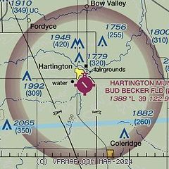
| Sectional chart |
|---|
|
| Airport distance calculator |
|---|
|
|
| Sunrise and sunset |
|---|
|
Times for 10-Jun-2026
| | Local
(UTC-5) | | Zulu
(UTC) |
|---|
| Morning civil twilight | | 05:17 | | 10:17 |
| Sunrise | | 05:52 | | 10:52 |
| Sunset | | 21:05 | | 02:05 |
| Evening civil twilight | | 21:40 | | 02:40 |
|
| Current date and time |
|---|
| Zulu (UTC) | 10-Jun-2026 07:13:16 |
|---|
| Local (UTC-5) | 10-Jun-2026 02:13:16 |
|---|
|
| METAR |
|---|
KVMR
17nm NE | SuperAWOS
100655Z AUTO 29012G21KT 10SM CLR 25/18 A2964 RMK AO2
|
KYKN
19nm N | 100656Z AUTO 23008KT 10SM -RA SCT110 22/18 A2965 RMK AO2 PK WND 27027/0609 RAB56 SLP040 P0000 T02170178
|
KLCG
25nm SE | 100655Z AUTO 21003KT 10SM CLR 23/16 A2964 RMK AO2 T02310162
|
|
| TAF |
|---|
KOFK
38nm S | 100520Z 1006/1106 21010KT P6SM FEW080 SCT220 FM100800 19012G20KT P6SM FEW080 FEW210 FM110300 12004KT P6SM SKC
|
KSUX
41nm E | 100520Z 1006/1106 18013G22KT P6SM VCSH BKN110 WS020/20042KT FM101300 22013G21KT P6SM FEW250 FM101800 29015G25KT P6SM SKC FM110000 29011KT P6SM SKC FM110300 VRB04KT P6SM SKC
|
|
| NOTAMs |
|---|
NOTAMs are issued by the DoD/FAA and will open in a separate window not controlled by AirNav.
|
|

