FAA INFORMATION EFFECTIVE 14 MAY 2026
Location
| FAA Identifier: | MRH |
| Lat/Long: | 34-44-01.5310N 076-39-37.2770W
34-44.025517N 076-39.621283W
34.7337586,-76.6603547
(estimated) |
| Elevation: | 10.1 ft. / 3.1 m (surveyed) |
| Variation: | 08W (1985) |
| From city: | 1 mile N of BEAUFORT, NC |
| Time zone: | UTC -4 (UTC -5 during Standard Time) |
| Zip code: | 28516 |
Airport Operations
| Airport use: | Open to the public |
| Activation date: | 06/1949 |
| Control tower: | no |
| ARTCC: | WASHINGTON CENTER |
| FSS: | RALEIGH FLIGHT SERVICE STATION |
| NOTAMs facility: | MRH (NOTAM-D service available) |
| Attendance: | 0800-DUSK
FOR SERVICE AFTER HOURS CALL 843-465-2846. |
| Pattern altitude: | TPA: SINGLE ENGINE 1000 FT AGL, TWIN ENGINE 1500 FT AGL. |
| Wind indicator: | lighted |
| Segmented circle: | yes |
| Lights: | ACTVT REIL RWY 08 & 26; PAPI RWY 03 & 21; MIRL RWY 03/21 & RWY 08/26 - CTAF. PAPI RWY 08 & 26 OPER CONSLY. |
| Beacon: | white-green (lighted land airport)
Operates sunset to sunrise. |
| International operations: | customs landing rights airport |
Airport Communications
| CTAF/UNICOM: | 122.8 |
| WX ASOS: | 135.375 (252-728-2055) |
| CHERRY POINT APPROACH: | 132.575 [0630-2300] |
| CHERRY POINT DEPARTURE: | 132.575 [0630-2300] |
| CLEARANCE DELIVERY: | 125.65 |
Nearby radio navigation aids
| VOR radial/distance | | VOR name | | Freq | | Var |
|---|
| EWNr145/27.8 | | NEW BERN VOR/DME | | 113.60 | | 08W |
Airport Services
| Fuel available: | 100LL JET-A1+ |
| Parking: | hangars and tiedowns |
| Airframe service: | MAJOR |
| Powerplant service: | MAJOR |
| Bottled oxygen: | HIGH/LOW |
| Bulk oxygen: | NONE |
Runway Information
Runway 8/26
| Dimensions: | 5004 x 100 ft. / 1525 x 30 m |
| Surface: | asphalt, in good condition |
| Weight bearing capacity: | |
| Runway edge lights: | medium intensity |
| RUNWAY 8 | | RUNWAY 26 |
| Latitude: | 34-43.987585N | | 34-44.296187N |
| Longitude: | 076-40.143842W | | 076-39.217192W |
| Elevation: | 6.4 ft. | | 9.6 ft. |
| Traffic pattern: | left | | right |
| Runway heading: | 076 magnetic, 068 true | | 256 magnetic, 248 true |
| Displaced threshold: | no | | 289 ft. |
| Markings: | nonprecision, in good condition | | nonprecision, in good condition |
| Visual slope indicator: | 2-light PAPI on left (3.00 degrees glide path) | | 2-light PAPI on right (3.00 degrees glide path) |
| Runway end identifier lights: | yes | | yes |
| Touchdown point: | yes, no lights | | yes, no lights |
| Obstructions: | 35 ft. boat, 1000 ft. from runway, 22:1 slope to clear
7 FT BRUSH 100-200 FT FM THR OFFSET 109 FT R OF CNTRLN. | | 20 ft. road, 325 ft. from runway, 6:1 slope to clear |
Runway 3/21
| Dimensions: | 4192 x 150 ft. / 1278 x 46 m |
| Surface: | asphalt, in excellent condition |
| Weight bearing capacity: | |
| Runway edge lights: | medium intensity |
| RUNWAY 3 | | RUNWAY 21 |
| Latitude: | 34-43.647803N | | 34-44.272613N |
| Longitude: | 076-39.714480W | | 076-39.356975W |
| Elevation: | 6.0 ft. | | 6.5 ft. |
| Traffic pattern: | left | | right |
| Runway heading: | 033 magnetic, 025 true | | 213 magnetic, 205 true |
| Displaced threshold: | 864 ft. | | 516 ft. |
| Markings: | nonprecision, in good condition | | nonprecision, in good condition |
| Visual slope indicator: | 2-light PAPI on left (4.00 degrees glide path) | | 2-light PAPI on left (4.00 degrees glide path) |
| Runway end identifier lights: | no | | no |
| Touchdown point: | yes, no lights | | yes, no lights |
| Obstructions: | 20 ft. road, 312 ft. from runway, 5:1 slope to clear
9 FT FENCE 191 FT FM END OF RWY BOTH SIDES OF CNTRLN. | | 43 ft. trees, 1125 ft. from runway, 170 ft. left of centerline, 21:1 slope to clear
13 FT TREES 63 FT FM END OF RWY OFFSET 165 FT R OF CNTRLN. |
Runway 14/32
| Dimensions: | 4001 x 100 ft. / 1220 x 30 m |
| Surface: | asphalt |
| Weight bearing capacity: | |
| Operational restrictions: | RWY 14/32 CLSD. |
| RUNWAY 14 | | RUNWAY 32 |
| Latitude: | 34-44.171438N | | 34-43.725350N |
| Longitude: | 076-39.931157W | | 076-39.342540W |
| Elevation: | 6.1 ft. | | 10.1 ft. |
| Traffic pattern: | left | | left |
| Runway heading: | 141 magnetic, 133 true | | 321 magnetic, 313 true |
| Displaced threshold: | no | | 490 ft. |
| Touchdown point: | yes, no lights | | yes, no lights |
Airport Ownership and Management from official FAA records
| Ownership: | Publicly-owned |
| Owner: | BEAUFORT-MOREHEAD ARPT AUTH
180 AIRPORT ROAD
BEAUFORT, NC 28516
Phone 252-728-1928 |
| Manager: | JANIE MASON
180 AIRPORT ROAD
BEAUFORT, NC 28516
Phone 252-728-1928 |
Additional Remarks
| A57-32 | APCH RATIO 13:1 AT DSPLCD THR DUE TO 61 FT TREES 995 FT FM DSPLCD THR OFFSET 85 FT R OF CNTRLN. |
| - | NO LINE OF SIGHT BTWN RWY ENDS. |
| - | DEER AND BIRDS ON & INVOF ARPT AND BIRD-DROPPED SHELLS MAY CAUSE FOD. |
| - | NOISE ABATEMENT PROCEDURES IN EFFECT, CTC AMGR 252-728-1928. |
| - | AVOID OVERFLIGHTS OF BEAUFORT WATERFRONT AND BEAUFORT NATIONAL REGISTER HISTORIC DISTRICT. |
| - | FOR CD CTC CHERRY POINT APCH AT 252-466-5960. |
| - | MIL ACFT RWY 08/26 REQUIRED FOR NOISE ABATEMENT. |
| - | SKYDIVING OPERATIONS - DO NOT OVERFLY ARPT. |
| - | DUE TO VOLUME OF MIL TFC AND TRNG RCMD ALL ACFT USING MRH CTC CHERRY POINT APP 132.57 AB AND 125.65 PRIOR TO MRH DEP. |
| A58-14 | 10 FT BRUSH 0-200 FT FM THR OFFSET 171 FT R OF CNTRLN, AND 11 FT TREES 43 FT FM THR OFFSET 206 FT R OF CNTRLN. |
| A52-14 | 45 FT MAST HGT. |
Instrument Procedures
NOTE: All procedures below are presented as PDF files. If you need a reader for these files, you should download the free Adobe Reader.NOT FOR NAVIGATION. Please procure official charts for flight.
FAA instrument procedures published for use from 14 May 2026 at 0901Z to 11 June 2026 at 0900Z.
IAPs - Instrument Approach Procedures |
|---|
| RNAV (GPS) RWY 03 | |
download (278KB) |
| RNAV (GPS) RWY 08 | |
download (252KB) |
| RNAV (GPS) RWY 14 | |
download (242KB) |
| RNAV (GPS) RWY 21 | |
download (226KB) |
| RNAV (GPS) RWY 26 | |
download (234KB) |
| RNAV (GPS) RWY 32 | |
download (269KB) |
| NOTE: Special Alternate Minimums apply | |
download (143KB) |
| NOTE: Special Take-Off Minimums/Departure Procedures apply | |
download (364KB) |
Other nearby airports with instrument procedures:
KNKT - Cherry Point Marine Corps Air Station (Cunningham Field) Airport (15 nm NW)
KEWN - Coastal Carolina Regional Airport (28 nm NW)
KNCA - New River Marine Corps Air Station (McCutcheon Field) Airport (38 nm W)
W95 - Ocracoke Island Airport (41 nm NE)
KOAJ - Albert J Ellis Airport (47 nm W)
|
|

Road maps at:
MapQuest
Bing
Google
| Aerial photo |
|---|
WARNING: Photo may not be current or correct
 Photo by Brian Corley
Photo taken 20-Jan-2015
looking southeast.
Photo by Brian Corley
Photo taken 20-Jan-2015
looking southeast.
Do you have a better or more recent aerial photo of Michael J Smith Field Airport that you would like to share? If so, please send us your photo.
|
| Sectional chart |
|---|
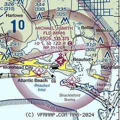
|
CAUTION: Diagram may not be current

| Airport distance calculator |
|---|
|
|
| Sunrise and sunset |
|---|
|
Times for 11-Jun-2026
| | Local
(UTC-4) | | Zulu
(UTC) |
|---|
| Morning civil twilight | | 05:24 | | 09:24 |
| Sunrise | | 05:54 | | 09:54 |
| Sunset | | 20:19 | | 00:19 |
| Evening civil twilight | | 20:48 | | 00:48 |
|
| Current date and time |
|---|
| Zulu (UTC) | 11-Jun-2026 04:41:54 |
|---|
| Local (UTC-4) | 11-Jun-2026 00:41:54 |
|---|
|
| METAR |
|---|
| KMRH | 110358Z AUTO 22011KT 10SM OVC020 24/22 A3001 RMK AO2 SLP163 T02440222
|
KNKT
14nm NW | 110355Z 22010KT 10SM CLR 24/22 A3001 RMK AO2 SLP160 T02440222
|
KNJM
18nm W | 110351Z AUTO 21011G21KT 8SM CLR 25/23 A3002 RMK AO2 SLP167 T02500228 $
|
KNBT
19nm NE | 110351Z AUTO 21011KT 10SM CLR 24/22 A3000 RMK AO2 SLP163 T02440222 PNO
|
|
| TAF |
|---|
KNKT
14nm NW | 110200Z 1103/1203 23015KT 9999 SKC QNH2991INS BECMG 1118/1120 21010G22KT 9999 SCT050 BKN200 QNH2987INS TX33/1119Z TN23/1110Z
|
|
| NOTAMs |
|---|
NOTAMs are issued by the DoD/FAA and will open in a separate window not controlled by AirNav.
|
|


