FAA INFORMATION EFFECTIVE 14 MAY 2026
Location
| FAA Identifier: | MYZ |
| Lat/Long: | 39-51-23.1450N 096-37-50.5650W
39-51.385750N 096-37.842750W
39.8564292,-96.6307125
(estimated) |
| Elevation: | 1283 ft. / 391.1 m (surveyed) |
| Variation: | 04E (2010) |
| From city: | 1 mile NE of MARYSVILLE, KS |
| Time zone: | UTC -5 (UTC -6 during Standard Time) |
| Zip code: | 66508 |
Airport Operations
| Airport use: | Open to the public |
| Activation date: | 12/1946 |
| Control tower: | no |
| ARTCC: | KANSAS CITY CENTER |
| FSS: | WICHITA FLIGHT SERVICE STATION |
| NOTAMs facility: | MYZ (NOTAM-D service available) |
| Attendance: | UNATNDD |
| Wind indicator: | lighted |
| Segmented circle: | yes |
| Lights: | ACTVT MIRL RWY 16/34; REIL RWY 16/34; PAPI RWY 16 & 34 - CTAF. |
| Beacon: | white-green (lighted land airport)
Operates sunset to sunrise. |
Airport Communications
| CTAF/UNICOM: | 122.8 |
| WX AWOS-3PT: | 118.675 (785-562-5059) |
- APCH/DEP CTL SVC PRVDD BY KANSAS CITY ARTCC (ZKC) ON FREQS 123.8/343.7 (TOPEKA RCAG).
Nearby radio navigation aids
| VOR radial/distance | | VOR name | | Freq | | Var |
|---|
| BIEr161/(27.3) | | BEATRICE VOR | | 110.60 | | 07E |
| NDB name | | Hdg/Dist | | Freq | | Var | | ID |
|---|
| FAIRBURY | | 122/31.2 | | 293 | | 06E | | FBY | ..-. -... -.-- |
Airport Services
| Parking: | tiedowns |
| Airframe service: | NONE |
| Powerplant service: | NONE |
Runway Information
Runway 16/34
| Dimensions: | 4200 x 60 ft. / 1280 x 18 m |
| Surface: | asphalt/aggregate friction seal coat, in excellent condition |
| Weight bearing capacity: | |
| Runway edge lights: | medium intensity |
| RUNWAY 16 | | RUNWAY 34 |
| Latitude: | 39-51.712000N | | 39-51.059500N |
| Longitude: | 096-37.992000W | | 096-37.693500W |
| Elevation: | 1277.9 ft. | | 1277.1 ft. |
| Traffic pattern: | left | | left |
| Runway heading: | 157 magnetic, 161 true | | 337 magnetic, 341 true |
| Markings: | nonprecision, in good condition | | nonprecision, in good condition |
| Visual slope indicator: | 2-light PAPI on left (3.00 degrees glide path) | | 2-light PAPI on left (3.00 degrees glide path) |
| Runway end identifier lights: | yes | | yes |
| Touchdown point: | yes, no lights | | yes, no lights |
| Obstructions: | none | | 58 ft. trees, 610 ft. from runway, 212 ft. left of centerline, 7:1 slope to clear |
Helipad H1
| Dimensions: | 50 x 50 ft. / 15 x 15 m |
| Surface: | concrete, in good condition |
| Runway edge lights: | non-standard
NSTD - RED LGTS AT CORNERS OF TLOF. ACTVT ON CTAF. |
| Runway edge markings: | NSTD - TLOF CNTR MKD WITH H ONLY. |
| Latitude: | 39-51.216000N | | |
| Longitude: | 096-37.933667W | | |
| Elevation: | 1285.0 ft. | | |
| Traffic pattern: | left | | left |
| Markings: | NSTD, in fair condition | | |
Airport Ownership and Management from official FAA records
| Ownership: | Publicly-owned |
| Owner: | CITY OF MARYSVILLE
209 N 8TH ST
MARYSVILLE, KS 66508
Phone 785-562-5331 |
| Manager: | CINDY HOLLE, CITY CLERK
209 N 8TH ST
MARYSVILLE, KS 66508
Phone 785-562-5331 |
Additional Remarks
| - | TV TWR +499 FT .9 MILES N OF ARPT APRXLY 1/4 MILE L OF AER 16. |
| - | FOR CD CTC KANSAS CITY ARTCC AT 913-254-8508. |
Instrument Procedures
NOTE: All procedures below are presented as PDF files. If you need a reader for these files, you should download the free Adobe Reader.NOT FOR NAVIGATION. Please procure official charts for flight.
FAA instrument procedures published for use from 14 May 2026 at 0901Z to 11 June 2026 at 0900Z.
IAPs - Instrument Approach Procedures |
|---|
| RNAV (GPS) RWY 16 | |
download (194KB) |
| RNAV (GPS) RWY 34 | |
download (187KB) |
| NOTE: Special Alternate Minimums apply | |
download (54KB) |
| NOTE: Special Take-Off Minimums/Departure Procedures apply | |
download (147KB) |
Other nearby airports with instrument procedures:
K38 - Washington County Veteran's Memorial Airport (21 nm W)
KBIE - Beatrice Municipal Airport (27 nm N)
KFBY - Fairbury Municipal Airport (31 nm NW)
KCYW - Clay Center Municipal Airport (37 nm SW)
0G3 - Tecumseh Municipal Airport (39 nm NE)
|
|

Road maps at:
MapQuest
Bing
Google
| Aerial photo |
|---|
WARNING: Photo may not be current or correct
 Photo taken 29-Aug-2014
looking south.
Photo taken 29-Aug-2014
looking south.
Do you have a better or more recent aerial photo of Marysville Municipal Airport that you would like to share? If so, please send us your photo.
|
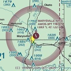
| Sectional chart |
|---|
|
| Airport distance calculator |
|---|
|
|
| Sunrise and sunset |
|---|
|
Times for 27-May-2026
| | Local
(UTC-5) | | Zulu
(UTC) |
|---|
| Morning civil twilight | | 05:32 | | 10:32 |
| Sunrise | | 06:04 | | 11:04 |
| Sunset | | 20:44 | | 01:44 |
| Evening civil twilight | | 21:15 | | 02:15 |
|
| Current date and time |
|---|
| Zulu (UTC) | 27-May-2026 17:35:33 |
|---|
| Local (UTC-5) | 27-May-2026 12:35:33 |
|---|
|
| METAR |
|---|
| KMYZ | 271655Z AUTO 13004KT 10SM SCT039 BKN046 26/14 A3003 RMK AO2
|
|
| TAF |
|---|
KMHK
43nm S | 271120Z 2712/2812 10008KT P6SM FEW050 SCT250
|
KFRI
50nm S | 271200Z 2712/2818 VRB05KT 9999 SKC QNH2996INS BECMG 2717/2718 10010G20KT 9999 SCT250 QNH3001INS BECMG 2800/2801 10005KT 9999 BKN070 QNH3002INS BECMG 2815/2816 10010G15KT 9000 -SHRA BKN080 QNH3006INS TX29/2721Z TN17/2811Z
|
|
| NOTAMs |
|---|
NOTAMs are issued by the DoD/FAA and will open in a separate window not controlled by AirNav.
|
|

