FAA INFORMATION EFFECTIVE 14 MAY 2026
Location
| FAA Identifier: | OEL |
| Lat/Long: | 39-06-42.3000N 100-49-00.3000W
39-06.705000N 100-49.005000W
39.1117500,-100.8167500
(estimated) |
| Elevation: | 3045.2 ft. / 928.2 m (surveyed) |
| Variation: | 08E (1995) |
| From city: | 2 miles SE of OAKLEY, KS |
| Time zone: | UTC -5 (UTC -6 during Standard Time) |
| Zip code: | 67748 |
Airport Operations
| Airport use: | Open to the public |
| Activation date: | 10/1953 |
| Control tower: | no |
| ARTCC: | DENVER CENTER |
| FSS: | WICHITA FLIGHT SERVICE STATION |
| NOTAMs facility: | ICT (NOTAM-D service available) |
| Attendance: | MON-FRI 0800-1700 |
| Wind indicator: | lighted |
| Segmented circle: | yes |
| Lights: | ACTVT REIL RWY 16 & 34; PAPI RWY 16 & 34; MIRL RWY 16/34 - CTAF. |
| Beacon: | white-green (lighted land airport)
Operates sunset to sunrise. |
Airport Communications
| CTAF/UNICOM: | 122.8 |
| WX AWOS-3: | 118.325 (785-671-4194) |
- APCH/DEP CTL SVC PRVDD BY DENVER ARTCC (ZDV) ON FREQS 132.7/226.675 (GOODLAND RCAG).
Nearby radio navigation aids
| VOR radial/distance | | VOR name | | Freq | | Var |
|---|
| HLCr244/28.9 | | HILL CITY VORTAC | | 113.70 | | 08E |
Airport Services
| Fuel available: | 100LL JET-A JET-A1+ |
| Parking: | hangars and tiedowns |
| Airframe service: | MAJOR |
| Powerplant service: | MAJOR |
Runway Information
Runway 16/34
| Dimensions: | 5000 x 75 ft. / 1524 x 23 m |
| Surface: | concrete, in excellent condition |
| Weight bearing capacity: | |
| Runway edge lights: | medium intensity |
| RUNWAY 16 | | RUNWAY 34 |
| Latitude: | 39-07.000865N | | 39-06.192650N |
| Longitude: | 100-49.087318W | | 100-48.884452W |
| Elevation: | 3045.2 ft. | | 3020.3 ft. |
| Traffic pattern: | left | | left |
| Runway heading: | 161 magnetic, 169 true | | 341 magnetic, 349 true |
| Declared distances: | TORA:5000 TODA:5000 ASDA:5000 LDA:5000 | | TORA:5000 TODA:5000 ASDA:5000 LDA:5000 |
| Markings: | nonprecision, in good condition | | nonprecision, in good condition |
| Visual slope indicator: | 2-light PAPI on left (3.00 degrees glide path)
PAPI UNUSBL BYD 8 DEG RIGHT & 6 DEG LEFT OF CNTRLN. | | 2-light PAPI on left (3.00 degrees glide path)
PAPI UNUSBL BYD 8 DEG LEFT OF CNTRLN. |
| Runway end identifier lights: | yes | | yes |
| Touchdown point: | yes, no lights | | yes, no lights |
| Obstructions: | 20 ft. bldg, 670 ft. from runway, 280 ft. left of centerline, 23:1 slope to clear | | none |
Runway 8/26
| Dimensions: | 2153 x 110 ft. / 656 x 34 m |
| Surface: | turf, in good condition |
| RUNWAY 8 | | RUNWAY 26 |
| Latitude: | 39-06.961105N | | 39-06.952418N |
| Longitude: | 100-49.278470W | | 100-48.823403W |
| Elevation: | 3042.0 ft. | | 3039.9 ft. |
| Traffic pattern: | left | | left |
| Runway heading: | 083 magnetic, 091 true | | 263 magnetic, 271 true |
| Markings: | none, in fair condition | | none, in fair condition |
| Touchdown point: | yes, no lights | | yes, no lights |
| Obstructions: | none | | 14 ft. road, 375 ft. from runway, 145 ft. left and right of centerline, 26:1 slope to clear |
Airport Ownership and Management from official FAA records
| Ownership: | Publicly-owned |
| Owner: | CITY OF OAKLEY
CITY HALL, 209 HUDSON AVE
OAKLEY, KS 67748
Phone 785-671-3136 |
| Manager: | JOHN HOLZMEISTER
CITY HALL, 209 HUDSON AVE
OAKLEY, KS 67748-6016
Phone 785-672-0147 |
Additional Remarks
| - | FUEL H24 SELF SVC. |
| - | SVC AFTER HR - 785-672-0147. |
| - | FOR CD CTC DENVER ARTCC AT 303-651-4257. |
Instrument Procedures
NOTE: All procedures below are presented as PDF files. If you need a reader for these files, you should download the free Adobe Reader.NOT FOR NAVIGATION. Please procure official charts for flight.
FAA instrument procedures published for use from 14 May 2026 at 0901Z to 11 June 2026 at 0900Z.
IAPs - Instrument Approach Procedures |
|---|
| RNAV (GPS) RWY 34 | |
download (250KB) |
| NOTE: Special Alternate Minimums apply | |
download (145KB) |
| NOTE: Special Take-Off Minimums/Departure Procedures apply | |
download (274KB) |
Other nearby airports with instrument procedures:
KCBK - Shalz Field Airport (22 nm NW)
1QK - Gove County Airport (28 nm E)
KTQK - Scott City Municipal Airport (38 nm S)
0H1 - Trego Wakeeney Airport (44 nm E)
KGLD - Renner Field/Goodland Municipal Airport (44 nm W)
|
|

Road maps at:
MapQuest
Bing
Google
| Aerial photo |
|---|
WARNING: Photo may not be current or correct
 Photo by Von Rothenberger and David Readio
Photo taken 18-Nov-2006
Photo by Von Rothenberger and David Readio
Photo taken 18-Nov-2006
Do you have a better or more recent aerial photo of Oakley Municipal Airport that you would like to share? If so, please send us your photo.
|
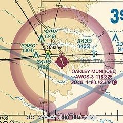
| Sectional chart |
|---|
|
| Airport distance calculator |
|---|
|
|
| Sunrise and sunset |
|---|
|
Times for 09-Jun-2026
| | Local
(UTC-5) | | Zulu
(UTC) |
|---|
| Morning civil twilight | | 05:46 | | 10:46 |
| Sunrise | | 06:18 | | 11:18 |
| Sunset | | 21:07 | | 02:07 |
| Evening civil twilight | | 21:39 | | 02:39 |
|
| Current date and time |
|---|
| Zulu (UTC) | 10-Jun-2026 03:31:09 |
|---|
| Local (UTC-5) | 09-Jun-2026 22:31:09 |
|---|
|
| METAR |
|---|
| KOEL | 100315Z AUTO 18016G23KT 10SM CLR 23/13 A2971 RMK AO1 T02280130
|
|
| TAF |
|---|
KGLD
44nm W | 100042Z 1001/1024 21012KT P6SM SCT120 TEMPO 0900/0902 15025G40KT 6SM HZ FM100900 27015G25KT P6SM FEW250 FM101400 33012G20KT P6SM SKC FM101900 16007KT P6SM SKC FM102200 15012G20KT P6SM SKC
|
|
| NOTAMs |
|---|
NOTAMs are issued by the DoD/FAA and will open in a separate window not controlled by AirNav.
|
|

