FAA INFORMATION EFFECTIVE 09 JULY 2026
Location
| FAA Identifier: | ORH |
| Lat/Long: | 42-16-01.7000N 071-52-32.2000W
42-16.028333N 071-52.536667W
42.2671389,-71.8756111
(estimated) |
| Elevation: | 1009 ft. / 307.5 m (surveyed) |
| Variation: | 15W (1995) |
| From city: | 3 miles W of WORCESTER, MA |
| Time zone: | UTC -4 (UTC -5 during Standard Time) |
| Zip code: | 01602 |
Airport Operations
| Airport use: | Open to the public |
| Activation date: | 02/1946 |
| Control tower: | yes |
| ARTCC: | BOSTON CENTER |
| FSS: | BRIDGEPORT FLIGHT SERVICE STATION |
| NOTAMs facility: | ORH (NOTAM-D service available) |
| Attendance: | CONTINUOUS |
| Wind indicator: | yes |
| Segmented circle: | yes |
| Lights: | ACTVT REIL RWY 15, 29 & 33; HIRL RWY 11/29; MIRL RWY 15/33 - CTAF. |
| Beacon: | white-green (lighted land airport)
Operates sunset to sunrise. |
| Landing fee: | yes, LDG FEE FOR MULTI-ENG ACFT & LRGR. |
| Fire and rescue: | ARFF index B |
| International operations: | customs landing rights airport
2 HRS ADVN NOTICE RQRD FOR CUST. |
Airport Communications
| CTAF: | 120.5 |
| UNICOM: | 122.95 |
| ATIS: | 126.55 |
| WX ASOS: | PHONE 508-767-5851 |
| WORCESTER GROUND: | 123.85 [0630-2100] |
| WORCESTER TOWER: | 120.5 263.0 [0630-2100] |
| BRADLEY APPROACH: | 119.0 |
| BRADLEY DEPARTURE: | 119.0 |
| CLEARANCE DELIVERY: | 119.0 ;WHEN TWR CLSD 128.65 |
| EMERG: | 121.5 243.0 |
| STELA STAR: | 125.35 |
| WX ASOS at FIT (18 nm N): | 135.175 (978-343-9121) |
Nearby radio navigation aids
| VOR radial/distance | | VOR name | | Freq | | Var |
|---|
| GDMr168/18.6 | | GARDNER VOR/DME | | 116.95 | | 14W |
| PUTr010/18.8 | | PUTNAM VOR/DME | | 117.40 | | 14W |
| BAFr094/37.9 | | BARNES VORTAC | | 113.00 | | 14W |
| PVDr343/38.2 | | PROVIDENCE VOR/DME | | 115.60 | | 14W |
| BOSr278/39.7 | | BOSTON VOR/DME | | 112.70 | | 16W |
Airport Services
| Fuel available: | 100LL JET-A |
| Parking: | hangars and tiedowns |
| Airframe service: | MAJOR |
| Powerplant service: | MAJOR |
| Bottled oxygen: | NONE |
Runway Information
Runway 11/29
| Dimensions: | 7001 x 150 ft. / 2134 x 46 m |
| Surface: | asphalt/grooved, in excellent condition |
| Weight bearing capacity: | | Single wheel: | 120.0 | | Double wheel: | 250.0 | | Double tandem: | 550.0 |
|
| Runway edge lights: | high intensity |
| RUNWAY 11 | | RUNWAY 29 |
| Latitude: | 42-16.039777N | | 42-15.962518N |
| Longitude: | 071-53.447762W | | 071-51.899420W |
| Elevation: | 980.0 ft. | | 987.9 ft. |
| Traffic pattern: | left | | left |
| Runway heading: | 109 magnetic, 094 true | | 289 magnetic, 274 true |
| Declared distances: | TORA:7001 TODA:7001 ASDA:7001 LDA:7001 | | TORA:7001 TODA:7001 ASDA:7001 LDA:7001 |
| Markings: | precision, in good condition | | precision, in good condition |
| Visual slope indicator: | 4-light PAPI on right (3.00 degrees glide path) | | 4-light PAPI on left (3.00 degrees glide path) |
| RVR equipment: | touchdown, midfield, rollout | | touchdown, midfield, rollout |
| Approach lights: | ALSF2: standard 2,400 foot high intensity approach lighting system with centerline sequenced flashers (category II or III)
RWY 11 ALSF-2 BECOMES SSALS PRESET ON MED INTST ONLY WHEN TWR CLSD. | | |
| Runway end identifier lights: | no | | yes |
| Centerline lights: | yes | | yes |
| Touchdown point: | yes, lighted | | yes, no lights |
| Instrument approach: | ILS/DME | | ILS/DME |
| Obstructions: | 110 ft. hill, 4500 ft. from runway, 39:1 slope to clear | | none |
Runway 15/33
| Dimensions: | 5000 x 100 ft. / 1524 x 30 m |
| Surface: | asphalt/grooved, in good condition |
| Weight bearing capacity: | | Single wheel: | 85.0 | | Double wheel: | 120.0 | | Double tandem: | 210.0 |
|
| Runway edge lights: | medium intensity |
| RUNWAY 15 | | RUNWAY 33 |
| Latitude: | 42-16.370725N | | 42-15.761453N |
| Longitude: | 071-52.719045W | | 071-51.973878W |
| Elevation: | 1008.9 ft. | | 997.9 ft. |
| Traffic pattern: | left | | left |
| Runway heading: | 153 magnetic, 138 true | | 333 magnetic, 318 true |
| Declared distances: | TORA:5000 TODA:5000 ASDA:5000 LDA:5000 | | TORA:5000 TODA:5000 ASDA:5000 LDA:5000 |
| Markings: | basic, in good condition | | nonprecision, in good condition |
| Visual slope indicator: | 4-box VASI on left (3.60 degrees glide path)
RWY 15 VASI UNUSBL BYD 9 DEG L OF CRS. | | 4-light PAPI on left (3.00 degrees glide path) |
| Runway end identifier lights: | yes | | yes |
| Touchdown point: | yes, no lights | | yes, no lights |
| Obstructions: | 252 ft. ant, 14000 ft. from runway, 10 ft. left of centerline, 47:1 slope to clear | | none |
Airport Ownership and Management from official FAA records
| Ownership: | Publicly-owned |
| Owner: | MASS PORT AUTHORITY
375 AIRPORT DR
WORCESTER, MA 01602
Phone 508-849-5550 |
| Manager: | ANDREW B DAVIS
WORCESTER REGIONAL AIRPORT, 5 AIRPORT DR
WORCESTER, MA 01602
Phone 508-849-5550 |
Additional Remarks
| A39-11/29 | PCR VALUE: 1400/F/D/W/T |
| A39-15/33 | PCR VALUE: 470/F/D/W/T |
| E60-11 | ENGRD MTRLS ARST SYS 170 FT WID, 154 FT LEN, LCTD AT DER 11. |
| E60-29 | ENGRD MTRLS ARST SYS 170 FT WID, 300 FT LEN, LCTD AT DER 29. |
| - | WILDLIFE & BIRDS ON & INVOF ARPT. |
| - | USE CTN FOR ARPT VEHICLES MNT CTAF & OPERG ON ARPT DURG NON-TWR HRS. |
| - | TSNT ACFT CTC FBO ON 122.95 FOR SVCS. |
| - | RWY GUARD LGTS INSTLD ON ALL TWY TO RWY INTXNS, RWY 11/29 ONLY. |
| - | WHEN ATCT CLSD, FOR CD CTC BRADLEY APCH 860-386-3597. |
Instrument Procedures
NOTE: All procedures below are presented as PDF files. If you need a reader for these files, you should download the free Adobe Reader.NOT FOR NAVIGATION. Please procure official charts for flight.
FAA instrument procedures published for use from 09 July 2026 at 0901Z to 06 August 2026 at 0900Z.
STARs - Standard Terminal Arrivals |
|---|
| STELA ONE (RNAV) **NEW** | |
download (218KB) |
IAPs - Instrument Approach Procedures |
|---|
| ILS OR LOC RWY 11 | |
download (282KB) |
| ILS OR LOC RWY 29 | |
download (237KB) |
| ILS RWY 11 (CAT II - III) | |
download (259KB) |
| RNAV (GPS) RWY 11 | |
download (221KB) |
| RNAV (GPS) RWY 29 | |
download (192KB) |
| RNAV (GPS) RWY 33 | |
download (214KB) |
| VOR/DME RWY 33 | |
download (227KB) |
| NOTE: Special Alternate Minimums apply | |
download (152KB) |
| NOTE: Special Take-Off Minimums/Departure Procedures apply | |
download (533KB) |
Other nearby airports with instrument procedures:
3B0 - Southbridge Municipal Airport (12 nm SW)
KFIT - Fitchburg Municipal Airport (18 nm N)
KGDM - Gardner Municipal Airport (18 nm N)
1B6 - Hopedale Industrial Park Airport (19 nm SE)
6B6 - Minute Man Air Field (20 nm NE)
|
|

Road maps at:
MapQuest
Bing
Google
| Aerial photo |
|---|
WARNING: Photo may not be current or correct
 Photo by Steve Socolosky
Photo taken 12-Oct-2015
looking northwest.
Photo by Steve Socolosky
Photo taken 12-Oct-2015
looking northwest.
Do you have a better or more recent aerial photo of Worcester Regional Airport that you would like to share? If so, please send us your photo.
|
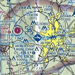
| Sectional chart |
|---|
|
 Download PDF
of official airport diagram from the FAA
| Airport distance calculator |
|---|
|
|
| Sunrise and sunset |
|---|
|
Times for 14-Jul-2026
| | Local
(UTC-4) | | Zulu
(UTC) |
|---|
| Morning civil twilight | | 04:51 | | 08:51 |
| Sunrise | | 05:24 | | 09:24 |
| Sunset | | 20:22 | | 00:22 |
| Evening civil twilight | | 20:56 | | 00:56 |
|
| Current date and time |
|---|
| Zulu (UTC) | 14-Jul-2026 18:39:29 |
|---|
| Local (UTC-4) | 14-Jul-2026 14:39:29 |
|---|
|
| METAR |
|---|
| KORH | 141754Z 25018G26KT 10SM CLR 27/19 A2995 RMK AO2 PK WND 24027/1735 SLP135 T02720189 10272 20211 58027 $
|
KFIT
18nm N | 141752Z AUTO VRB05G18KT 10SM CLR 29/19 A2990 RMK AO2 SLP122 T02890194 10289 20239 58030
|
|
| TAF |
|---|
| KORH | 141724Z 1418/1518 25012G25KT P6SM SCT250 FM150700 27010G19KT P6SM FEW250 FM151400 30010G21KT P6SM FEW250
|
|
| NOTAMs |
|---|
NOTAMs are issued by the DoD/FAA and will open in a separate window not controlled by AirNav.
|
|


