FAA INFORMATION EFFECTIVE 09 JULY 2026
Location
| FAA Identifier: | 6B6 |
| Lat/Long: | 42-27-37.3875N 071-31-04.8428W
42-27.623125N 071-31.080713W
42.4603854,-71.5180119
(estimated) |
| Elevation: | 280 ft. / 85 m (estimated) |
| Variation: | 16W (1985) |
| From city: | 2 miles N of STOW, MA |
| Time zone: | UTC -4 (UTC -5 during Standard Time) |
| Zip code: | 01775 |
Airport Operations
| Airport use: | Open to the public |
| Control tower: | no |
| ARTCC: | BOSTON CENTER |
| FSS: | BRIDGEPORT FLIGHT SERVICE STATION |
| NOTAMs facility: | BDR (NOTAM-D service available) |
| Attendance: | 0900-1600 |
| Pattern altitude: | 1312 ft. MSL |
| Wind indicator: | yes |
| Segmented circle: | yes |
| Lights: | ACTVT REIL RWY 21 - CTAF. |
| Beacon: | white-green (lighted land airport)
Operates sunset to sunrise. |
Airport Communications
| CTAF/UNICOM: | 122.8 |
| BOSTON APPROACH: | 124.4 |
| BOSTON DEPARTURE: | 124.4 |
| WX ASOS at BED (10 nm E): | 124.6 (781-372-5512) |
| WX ASOS at FIT (12 nm NW): | 135.175 (978-343-9121) |
| WX AWOS-3PT at ASH (19 nm N): | 125.1 (603-578-0473) |
| WX ASOS at ORH (20 nm SW): | PHONE 508-767-5851 |
Nearby radio navigation aids
| VOR radial/distance | | VOR name | | Freq | | Var |
|---|
| BOSr301/24.2 | | BOSTON VOR/DME | | 112.70 | | 16W |
| GDMr116/24.4 | | GARDNER VOR/DME | | 116.95 | | 14W |
| PUTr040/33.6 | | PUTNAM VOR/DME | | 117.40 | | 14W |
Airport Services
| Fuel available: | 100LL |
| Parking: | hangars and tiedowns |
| Airframe service: | MAJOR |
| Powerplant service: | MAJOR |
| Bottled oxygen: | NONE |
| Bulk oxygen: | NONE |
Runway Information
Runway 3/21
| Dimensions: | 3110 x 48 ft. / 948 x 15 m |
| Surface: | asphalt, in excellent condition |
| Weight bearing capacity: | |
| Runway edge lights: | low intensity |
| RUNWAY 3 | | RUNWAY 21 |
| Latitude: | 42-27.398000N | | 42-27.888167N |
| Longitude: | 071-31.230833W | | 071-31.032333W |
| Elevation: | 280.0 ft. | | 268.0 ft. |
| Traffic pattern: | left | | left |
| Runway heading: | 033 magnetic, 017 true | | 213 magnetic, 197 true |
| Markings: | basic, in good condition | | nonprecision, in good condition |
| Visual slope indicator: | | | 2-light PAPI on left (3.50 degrees glide path) |
| Runway end identifier lights: | | | yes |
| Touchdown point: | yes, no lights | | yes, no lights |
| Obstructions: | 156 ft. trees, lighted, 2085 ft. from runway, 13:1 slope to clear | | 98 ft. trees, marked, 1750 ft. from runway, 150 ft. left of centerline, 15:1 slope to clear |
Runway 12/30
| Dimensions: | 1600 x 40 ft. / 488 x 12 m |
| Surface: | turf, in excellent condition |
| RUNWAY 12 | | RUNWAY 30 |
| Latitude: | 42-27.621833N | | 42-27.546833N |
| Longitude: | 071-31.152333W | | 071-30.811333W |
| Elevation: | 259.0 ft. | | 254.0 ft. |
| Traffic pattern: | left | | left |
| Runway heading: | 122 magnetic, 106 true | | 302 magnetic, 286 true |
| Touchdown point: | yes, no lights | | yes, no lights |
| Obstructions: | 30 ft. trees, 300 ft. from runway, 125 ft. of centerline, 10:1 slope to clear | | 50 ft. trees, 400 ft. from runway, 125 ft. left of centerline, 8:1 slope to clear |
Airport Ownership and Management from official FAA records
| Ownership: | Privately-owned |
| Owner: | MINUTE MAN AIRFIELD INC
302 BOXBORO RD
STOW, MA 01775
Phone 978-897-3933 |
| Manager: | DONALD MC PHERSON
302 BOXBORO RD
STOW, MA 01775
Phone 978-897-3933 |
Additional Remarks
| - | TPA FOR LGT ACFT 1032 FT AGL. |
| - | BFR USING RWY 12/30 CALL AMGR TO DTRM RWY CONDS. |
| - | TREE OBSTN IN APCH; PRIM & TRSN SFCS RWYS 03 & 12/30. |
| - | NOISE ABATEMENT PROCS IN EFCT NTFY AMGR 978-897-3933 OF INTN TO OPR BTN 2300-0600. |
| - | FOR CD CTC BOSTON APCH AT 603-594-5552. |
Instrument Procedures
NOTE: All procedures below are presented as PDF files. If you need a reader for these files, you should download the free Adobe Reader.NOT FOR NAVIGATION. Please procure official charts for flight.
FAA instrument procedures published for use from 09 July 2026 at 0901Z to 06 August 2026 at 0900Z.
IAPs - Instrument Approach Procedures |
|---|
| RNAV (GPS) RWY 21 | |
download (201KB) |
| NOTE: Special Take-Off Minimums/Departure Procedures apply | |
download (472KB) |
Other nearby airports with instrument procedures:
KBED - Laurence G Hanscom Field Airport (10 nm E)
KFIT - Fitchburg Municipal Airport (12 nm NW)
KASH - Boire Field Airport (19 nm N)
KORH - Worcester Regional Airport (20 nm SW)
1B6 - Hopedale Industrial Park Airport (21 nm S)
|
|

Road maps at:
MapQuest
Bing
Google
| Aerial photo |
|---|
WARNING: Photo may not be current or correct
 Photo by Karl Swenson
Photo taken 29-Sep-2013
looking northwest.
Photo by Karl Swenson
Photo taken 29-Sep-2013
looking northwest.
Do you have a better or more recent aerial photo of Minute Man Air Field that you would like to share? If so, please send us your photo.
|
| Sectional chart |
|---|
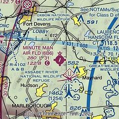
|
| Airport distance calculator |
|---|
|
|
| Sunrise and sunset |
|---|
|
Times for 17-Jul-2026
| | Local
(UTC-4) | | Zulu
(UTC) |
|---|
| Morning civil twilight | | 04:51 | | 08:51 |
| Sunrise | | 05:25 | | 09:25 |
| Sunset | | 20:19 | | 00:19 |
| Evening civil twilight | | 20:53 | | 00:53 |
|
| Current date and time |
|---|
| Zulu (UTC) | 17-Jul-2026 12:28:31 |
|---|
| Local (UTC-4) | 17-Jul-2026 08:28:31 |
|---|
|
| METAR |
|---|
KBED
10nm E | 171151Z 27006KT 10SM CLR 20/11 A2999 RMK AO2 SLP168 T02000106 10200 20128 51018
|
KFIT
12nm NW | 171152Z AUTO 30008KT 10SM CLR 20/10 A3002 RMK AO2 SLP166 T02000100 10200 20128 53014
|
KASH
18nm N | 171156Z 29009KT 10SM CLR 19/12 A3000 RMK AO2 SLP159 6//// 7//// T01890117 10189 20117 51015 PNO $
|
KORH
19nm SW | 171154Z 33009KT 10SM CLR 19/08 A3004 RMK AO2 SLP168 T01890078 10189 20150 51014
|
|
| TAF |
|---|
KBED
10nm E | 171120Z 1712/1812 27004KT P6SM FEW250 FM171600 32005KT P6SM FEW250 FM180000 VRB03KT P6SM FEW250 FM180400 23004KT 6SM FU BKN200
|
KORH
19nm SW | 171120Z 1712/1812 33005KT P6SM FEW250 FM180200 27003KT 6SM FU SCT200 FM181000 23004KT 6SM FU SCT150
|
|
| NOTAMs |
|---|
NOTAMs are issued by the DoD/FAA and will open in a separate window not controlled by AirNav.
|
|

