FAA INFORMATION EFFECTIVE 19 FEBRUARY 2026
Location
| FAA Identifier: | BED |
| Lat/Long: | 42-28-11.8000N 071-17-20.4000W
42-28.196667N 071-17.340000W
42.4699444,-71.2890000
(estimated) |
| Elevation: | 132 ft. / 40.2 m (surveyed) |
| Variation: | 16W (1995) |
| Time zone: | UTC -5 (UTC -4 during Daylight Saving Time) |
| Zip code: | 01730 |
Airport Operations
| Airport use: | Open to the public |
| Activation date: | 04/1943 |
| Control tower: | yes |
| ARTCC: | BOSTON CENTER |
| FSS: | BRIDGEPORT FLIGHT SERVICE STATION |
| NOTAMs facility: | BED (NOTAM-D service available) |
| Attendance: | CONTINUOUS |
| Pattern altitude: | 1000 FT AGL FIXED WING; 1500 FT AGL TURBOJET; 1800 FT AGL HEAVY JET ACFT. |
| Wind indicator: | lighted |
| Segmented circle: | yes |
| Lights: | ACTVT MALSR RWY 11 & 29; REIL RWY 05 & 23; HIRL RWY 11/29; MIRL RWY 05/23; TWY LGTS - 118.5. |
| Beacon: | white-green (lighted land airport)
Operates sunset to sunrise. |
| Landing fee: | yes, SURCHARGE FOR EACH LDG & DEP 2300-0700. COML & TSNT LDG FEE. |
| Fire and rescue: | ARFF index B |
| Airline operations: | CLSD TO PART 121 ACR OPS WITH OVR 60 SEATS EXCP 24 HR PPR CALL 781-869-8000. |
| International operations: | US CUSTOMS USER FEE ARPT. |
Airport Communications
| CTAF: | 118.5 |
| UNICOM: | 122.95 |
| ATIS: | 124.6 |
| WX ASOS: | 124.6 (781-372-5512) |
| HANSCOM GROUND: | 121.7 [0700-2300] |
| HANSCOM TOWER: | 118.5 257.2 [0700-2300] |
| BOSTON APPROACH: | 124.4 |
| BOSTON DEPARTURE: | 124.4 |
| CLEARANCE DELIVERY: | 121.85 |
| COMD POST: | 362.95 |
| DREEM STAR: | 119.0 124.4 |
| EMERG: | 121.5 243.0 |
| ZELKA STAR: | 124.4 |
| WX ASOS at BOS (14 nm SE): | 135.0 (339-746-6855) |
| WX ASOS at LWM (17 nm NE): | PHONE 978-687-8017 |
| WX ASOS at OWD (18 nm S): | 119.95 (781-762-4314) |
| WX ASOS at BVY (18 nm NE): | 119.2 (978-921-5042) |
Nearby radio navigation aids
| VOR radial/distance | | VOR name | | Freq | | Var |
|---|
| BOSr313/14.9 | | BOSTON VOR/DME | | 112.70 | | 16W |
| GDMr112/34.3 | | GARDNER VOR/DME | | 116.95 | | 14W |
| PUTr053/39.5 | | PUTNAM VOR/DME | | 117.40 | | 14W |
Airport Services
| Fuel available: | 100LL JET-A |
| Parking: | hangars and tiedowns |
| Airframe service: | MAJOR |
| Powerplant service: | MAJOR |
| Bottled oxygen: | HIGH/LOW |
| Bulk oxygen: | HIGH/LOW |
Runway Information
Runway 11/29
| Dimensions: | 7011 x 150 ft. / 2137 x 46 m |
| Surface: | asphalt/grooved, in good condition |
| Weight bearing capacity: | | Single wheel: | 120.0 | | Double wheel: | 250.0 | | Double tandem: | 389.0 | | Dual double tandem: | 916.0 |
|
| Runway edge lights: | high intensity |
| RUNWAY 11 | | RUNWAY 29 |
| Latitude: | 42-28.309423N | | 42-28.166158N |
| Longitude: | 071-18.020578W | | 071-16.473593W |
| Elevation: | 132.0 ft. | | 123.0 ft. |
| Traffic pattern: | left | | left |
| Runway heading: | 113 magnetic, 097 true | | 293 magnetic, 277 true |
| Declared distances: | TORA:7011 TODA:7011 ASDA:7011 LDA:7011 | | TORA:7011 TODA:7011 ASDA:7011 LDA:7011 |
| Markings: | precision, in good condition | | precision, in good condition |
| Visual slope indicator: | 4-light PAPI on left (3.00 degrees glide path) | | 4-light PAPI on right (3.00 degrees glide path) |
| RVR equipment: | touchdown | | rollout |
| Approach lights: | MALSR: 1,400 foot medium intensity approach lighting system with runway alignment indicator lights | | MALSR: 1,400 foot medium intensity approach lighting system with runway alignment indicator lights |
| Runway end identifier lights: | no | | no |
| Touchdown point: | yes, no lights | | yes, no lights |
| Instrument approach: | ILS/DME | | ILS/DME |
| Obstructions: | 120 ft. hill, lighted, 1050 ft. from runway, 734 ft. right of centerline, 34:1 slope to clear | | none |
Runway 5/23
| Dimensions: | 5107 x 150 ft. / 1557 x 46 m |
| Surface: | asphalt/grooved, in good condition |
| Weight bearing capacity: | | Single wheel: | 120.0 | | Double wheel: | 248.0 | | Double tandem: | 323.0 | | Dual double tandem: | 823.0 |
|
| Runway edge lights: | medium intensity |
| RUNWAY 5 | | RUNWAY 23 |
| Latitude: | 42-27.806147N | | 42-28.476517N |
| Longitude: | 071-17.812088W | | 071-17.126562W |
| Elevation: | 128.0 ft. | | 127.8 ft. |
| Traffic pattern: | left | | left |
| Runway heading: | 053 magnetic, 037 true | | 233 magnetic, 217 true |
| Declared distances: | TORA:5107 TODA:5107 ASDA:5107 LDA:5107 | | TORA:5107 TODA:5107 ASDA:5107 LDA:5107 |
| Markings: | nonprecision, in good condition | | nonprecision, in good condition |
| Visual slope indicator: | 4-light PAPI on left (3.50 degrees glide path) | | 4-light PAPI on right (3.20 degrees glide path) |
| Runway end identifier lights: | yes | | yes |
| Touchdown point: | yes, no lights | | yes, no lights |
Airport Ownership and Management from official FAA records
| Ownership: | Publicly-owned |
| Owner: | MASS PORT AUTHORITY
ONE HARBORSIDE DR
E BOSTON, MA 02128
Phone 617-212-6592 |
| Manager: | CHRISTOPHER J. WILLENBORG
MASSPORT, 200 HANSCOM DR
BEDFORD, MA 01730
Phone 617-212-6592 |
Additional Remarks
| A39-05/23 | PCR VALUE: 770/F/D/W/T |
| A39-11/29 | PCR VALUE: 950/F/D/W/T |
| A23 | RWY 29 RIGHT TFC ACFT OVR 12500 LBS. |
| - | PPR FOR ALL ACFT CARRYING XPLOS CALL 617-212-6592. |
| - | TWY C, F, J, N, R, S, T, TWY M SOUTH OF TWY E & TWY G BTN RWY 11/29 & RWY 05/23 CLSD TO ACFT GTR THAN 118 FT WINGSPAN. TWY R CLSD TO ACR OPS-GA USE ONLY. |
| - | NO PLAS/TGLS FOR ACFT UNDER 12500 LBS BTN 2300-0700. |
| - | SVC-TRAN ALERT: OPR 1200-0400Z++ WKD; 1400-2200Z++ SUN; PPR OT AND HOL DSN 845-5589/5592. DE-ICING AVBL FR VENDOR. |
| - | AF: PPR ALL MIL ACFT, PAX MNFST REQ ALL INBD PAX, CTC BASE OPS DSN 845-5589/5592, C781-225-5589/5592. |
| - | AF: COMD POST DSN 845-6960/6961, C781-225-6960/6961. |
| - | NO PLAS/TGLS FOR ACFT 12500 LBS & OVR. |
| - | VOLUNTARY NOISE ABATEMENT PROCS IN EFCT CTC AMGR 617-212-6592. NOISE SENSITIVE HISTORIC AREA S OF ARPT; FOR RWY 23 DEP CONT RWY HDG TO 1000 FT AGL, TURNING CROSSWIND OVR RTE 2. |
| - | SERVICE: MIL ACFT MUST ARNG FOR PRKG ON EAST RAMP WITH TRAN ALERT OR VENDOR. |
| - | TWY R1, R2 CLSD TO ACFT GTR THAN 49 FT WINGSPAN. |
| - | APU-GPU OPS LTD TO MAX OF 30 MINS. |
| - | NOISE ABATEMENT PROCS IN EFCT - HELS OPERG WI CNTLD ASP ARE RQRD TO MNTN HIST PSBL ALT. |
| - | SUPPORT: OPR 1200-0400Z++ MON-FRI, 1300-1900Z++ SAT & SUN, CLSD HOL. CTC BASE OPS PRIOR TO 1700Z++ FRI FOR OT SUPPORT. |
| - | BIRDS & WILDLIFE ON & INVOF ARPT. |
| - | BE ALERT FOR SML ACFT PARKED ON RAMPS. |
Instrument Procedures
NOTE: All procedures below are presented as PDF files. If you need a reader for these files, you should download the free Adobe Reader.NOT FOR NAVIGATION. Please procure official charts for flight.
FAA instrument procedures published for use from 19 February 2026 at 0901Z to 19 March 2026 at 0900Z.
STARs - Standard Terminal Arrivals |
|---|
| DREEM THREE (RNAV) **CHANGED** | |
2 pages:
[1] [2] (349KB) |
| ZELKA TWO (RNAV) | |
download (146KB) |
IAPs - Instrument Approach Procedures |
|---|
| ILS OR LOC RWY 11 **CHANGED** | |
download (286KB) |
| ILS OR LOC RWY 29 **CHANGED** | |
download (237KB) |
| RNAV (GPS) RWY 11 **CHANGED** | |
download (244KB) |
| RNAV (GPS) RWY 23 **CHANGED** | |
download (220KB) |
| RNAV (GPS) RWY 29 **CHANGED** | |
download (214KB) |
| NOTE: Special Alternate Minimums apply | |
download (150KB) |
Departure Procedures |
|---|
| HANSCOM FIVE | |
2 pages:
[1] [2] (341KB) |
| NOTE: Special Take-Off Minimums/Departure Procedures apply | |
download (510KB) |
Other nearby airports with instrument procedures:
6B6 - Minute Man Air Field (10 nm W)
KBOS - General Edward Lawrence Logan International Airport (14 nm SE)
KLWM - Lawrence Municipal Airport (17 nm NE)
KOWD - Norwood Memorial Airport (18 nm S)
KBVY - Beverly Regional Airport (18 nm NE)
|
|

Road maps at:
MapQuest
Bing
Google
| Aerial photo |
|---|
WARNING: Photo may not be current or correct

Do you have a better or more recent aerial photo of Laurence G Hanscom Field Airport that you would like to share? If so, please send us your photo.
|
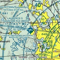
| Sectional chart |
|---|
|
CAUTION: Diagram may not be current
 Download PDF
of official airport diagram from the FAA
| Airport distance calculator |
|---|
|
|
| Sunrise and sunset |
|---|
|
Times for 03-Mar-2026
| | Local
(UTC-5) | | Zulu
(UTC) |
|---|
| Morning civil twilight | | 05:50 | | 10:50 |
| Sunrise | | 06:19 | | 11:19 |
| Sunset | | 17:36 | | 22:36 |
| Evening civil twilight | | 18:04 | | 23:04 |
|
| Current date and time |
|---|
| Zulu (UTC) | 03-Mar-2026 19:32:13 |
|---|
| Local (UTC-5) | 03-Mar-2026 14:32:13 |
|---|
|
| METAR |
|---|
| KBED | 031851Z 21004KT 2SM R11/6000VP6000FT -SN BKN020 OVC050 M02/M07 A3050 RMK AO2 SLP344 P0000 T10171067
|
KBOS
14nm SE | 031854Z 19006KT 10SM -SN BKN047 OVC060 00/M07 A3051 RMK AO2 SLP331 P0000 T00001072
|
KLWM
16nm NE | 031908Z 21005KT 2SM SN OVC028 M02/M06 A3052 RMK AO2 P0000 T10171061
|
KBVY
18nm NE | 031912Z 22005KT 1 3/4SM -SN BKN035 BKN041 OVC070 M02/M06 A3050 RMK AO2 SNB00 P0000 T10171061
|
KOWD
18nm S | 031907Z VRB03KT 5SM -SN SCT038 OVC047 00/M05 A3050 RMK AO2 P0000 T00001050
|
|
| TAF |
|---|
| KBED | 031739Z 0318/0418 20007KT 6SM -SN BR OVC035 FM031900 16004KT 1SM -SN BR OVC020 FM032200 12003KT 1SM -FZRAPL BR OVC008 FM040200 00000KT 1SM -FZRA BR OVC003 FM040700 28003KT 1 1/2SM BR OVC007 FM041300 30005KT P6SM SCT010
|
KBOS
14nm SE | 031739Z 0318/0424 17006KT 6SM -SN BR OVC030 FM032100 16006KT 2SM -SN BR OVC008 FM032200 16006KT 2SM -SNPL BR OVC008 FM040000 02006KT 1 1/2SM -RA BR OVC007 FM040900 28007KT 1 1/2SM BR OVC007 FM041300 31008KT P6SM SCT010
|
|
| NOTAMs |
|---|
NOTAMs are issued by the DoD/FAA and will open in a separate window not controlled by AirNav.
|
|


