FAA INFORMATION EFFECTIVE 16 APRIL 2026
Location
| FAA Identifier: | PEZ |
| Lat/Long: | 28-57-15.1000N 098-31-11.9000W
28-57.251667N 098-31.198333W
28.9541944,-98.5199722
(estimated) |
| Elevation: | 430.4 ft. / 131.2 m (surveyed) |
| Variation: | 06E (2000) |
| From city: | 3 miles W of PLEASANTON, TX |
| Time zone: | UTC -5 (UTC -6 during Standard Time) |
| Zip code: | 78064 |
Airport Operations
| Airport use: | Open to the public |
| Activation date: | 10/1970 |
| Control tower: | no |
| ARTCC: | HOUSTON CENTER |
| FSS: | SAN ANGELO FLIGHT SERVICE STATION |
| NOTAMs facility: | SJT (NOTAM-D service available) |
| Attendance: | MON-FRI 0800-1700
FOR SVCS CALL 830-569-3155. |
| Wind indicator: | lighted |
| Segmented circle: | yes |
| Lights: | DUSK-DAWN. MIRL RWY 16/34 PRESET LOW INTST; TO INCR INTST ACTVT - CTAF. |
| Beacon: | white-green (lighted land airport)
Operates sunset to sunrise. |
Airport Communications
| CTAF/UNICOM: | 122.7 |
| WX AWOS-3: | 118.575 (830-569-5749) |
| SAN ANTONIO APPROACH: | 118.05 |
| SAN ANTONIO DEPARTURE: | 125.7 |
| CLEARANCE DELIVERY: | 121.375 |
| CRVZA RNAV STAR: | 125.7 |
| DNKIN RNAV STAR: | 125.1 |
| POPPO RNAV STAR: | 125.1 |
| QERVO RNAV STAR: | 127.1 |
Nearby radio navigation aids
| VOR radial/distance | | VOR name | | Freq | | Var |
|---|
| SSFr189/(18.7) | | STINSON VOR | | 108.40 | | 03E |
| RNDr195/36.1 | | RANDOLPH VORTAC | | 112.30 | | 05E |
| NDB name | | Hdg/Dist | | Freq | | Var | | ID |
|---|
| DEVINE | | 110/24.6 | | 359 | | 07E | | HHH | .... .... .... |
Airport Services
| Fuel available: | 100LL JET-A JET-A+
100LL:100 LL AND JET A SELF SERVE. JET A AVBL FULL SERVE DURING ATTND HRS AND ON CALL AFTER HRS. |
| Parking: | hangars and tiedowns |
| Bottled oxygen: | NONE |
| Bulk oxygen: | NONE |
Runway Information
Runway 16/34
| Dimensions: | 4000 x 75 ft. / 1219 x 23 m |
| Surface: | asphalt, in good condition |
| Weight bearing capacity: | |
| Runway edge lights: | medium intensity |
| RUNWAY 16 | | RUNWAY 34 |
| Latitude: | 28-57.567317N | | 28-56.935795N |
| Longitude: | 098-31.308103W | | 098-31.089988W |
| Elevation: | 430.3 ft. | | 400.2 ft. |
| Traffic pattern: | left | | left |
| Runway heading: | 157 magnetic, 163 true | | 337 magnetic, 343 true |
| Displaced threshold: | 405 ft. | | no |
| Markings: | nonprecision, in good condition | | nonprecision, in good condition |
| Visual slope indicator: | 2-light PAPI on left (4.00 degrees glide path) | | 2-light PAPI on left (3.00 degrees glide path) |
| Touchdown point: | yes, no lights | | yes, no lights |
| Obstructions: | 16 ft. road, 201 ft. from runway, 250 ft. left and right of centerline
8 FT FENCE, 36 FT DSTC, 220 FT L. | | 8 ft. fence, 201 ft. from runway, 90 ft. right of centerline
8 FT FENCE, 0-199 FT DSTC, R/L. |
Airport Ownership and Management from official FAA records
| Ownership: | Publicly-owned |
| Owner: | CITY OF PLEASANTON
BOX 209
PLEASANTON, TX 78064
Phone 830-569-3867 |
| Manager: | JOHN ROBERTS
PO BOX 209
PLEASANTON, TX 78064
Phone 830-569-3155
EXT 800 |
Additional Remarks
| - | FOR CD IF UNA TO CTC VIA FREQ, CTC SAN ANTONIO APCH AT 210-805-5516. |
Instrument Procedures
NOTE: All procedures below are presented as PDF files. If you need a reader for these files, you should download the free Adobe Reader.NOT FOR NAVIGATION. Please procure official charts for flight.
FAA instrument procedures published for use from 16 April 2026 at 0901Z to 14 May 2026 at 0900Z.
STARs - Standard Terminal Arrivals |
|---|
| CRVZA TWO (RNAV) | |
2 pages:
[1] [2] (301KB) |
| CRVZA TWO (RNAV), CONT.2 | |
download (205KB) |
| DNKIN TWO (RNAV) | |
2 pages:
[1] [2] (441KB) |
| POPPO TWO (RNAV) | |
2 pages:
[1] [2] (314KB) |
| POPPO TWO (RNAV), CONT.2 | |
download (237KB) |
| QERVO THREE (RNAV) | |
2 pages:
[1] [2] (388KB) |
| QERVO THREE (RNAV), CONT.2 | |
download (273KB) |
IAPs - Instrument Approach Procedures |
|---|
| RNAV (GPS) RWY 34 **CHANGED** | |
download (190KB) |
| NOTE: Special Alternate Minimums apply | |
download (20KB) |
Departure Procedures |
|---|
| ALISS SEVEN (RNAV) | |
download (141KB) |
| SLENA TWO (RNAV) | |
download (146KB) |
| SNIDR TWO (RNAV) | |
download (216KB) |
| TJANO TWO (RNAV) | |
download (155KB) |
| YODUH TWO (RNAV) | |
download (175KB) |
| NOTE: Special Take-Off Minimums/Departure Procedures apply | |
download (105KB) |
Other nearby airports with instrument procedures:
KSSF - Stinson Municipal Airport (23 nm N)
23R - Devine Municipal Airport (25 nm NW)
KSKF - Kelly Field Airport (26 nm N)
KCVB - Castroville Municipal Airport (29 nm NW)
T30 - Mc Kinley Field Airport (32 nm W)
|
|

Road maps at:
MapQuest
Bing
Google
| Aerial photo |
|---|
WARNING: Photo may not be current or correct
 Taken early June 2006
Do you have a better or more recent aerial photo of Pleasanton Municipal Airport that you would like to share? If so, please send us your photo.
|
| Sectional chart |
|---|
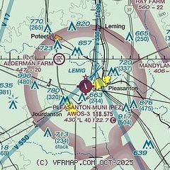
|
| Airport distance calculator |
|---|
|
|
| Sunrise and sunset |
|---|
|
Times for 04-May-2026
| | Local
(UTC-5) | | Zulu
(UTC) |
|---|
| Morning civil twilight | | 06:26 | | 11:26 |
| Sunrise | | 06:51 | | 11:51 |
| Sunset | | 20:11 | | 01:11 |
| Evening civil twilight | | 20:36 | | 01:36 |
|
| Current date and time |
|---|
| Zulu (UTC) | 04-May-2026 06:36:14 |
|---|
| Local (UTC-5) | 04-May-2026 01:36:14 |
|---|
|
| METAR |
|---|
| KPEZ | 040615Z AUTO 16006KT 10SM CLR 19/13 A3006 RMK AO2 T01880130
|
|
| TAF |
|---|
KSSF
23nm N | 040529Z 0406/0506 15008KT P6SM BKN250 FM041400 19010KT P6SM BKN023 BKN250 FM041600 18011KT P6SM SCT035 BKN250 FM050100 15011KT P6SM BKN250
|
KSKF
25nm N | 040200Z 0402/0508 15006KT 9999 SCT050 BKN200 QNH2992INS BECMG 0409/0410 17006KT 9999 SCT018 BKN100 QNH2992INS BECMG 0414/0415 18012G20KT 9999 FEW030 FEW200 QNH2973INS BECMG 0506/0507 17009KT 9999 BKN017 QNH2973INS TX29/0422Z TN17/0412Z
|
|
| NOTAMs |
|---|
NOTAMs are issued by the DoD/FAA and will open in a separate window not controlled by AirNav.
|
|

