FAA INFORMATION EFFECTIVE 22 JANUARY 2026
Location
| FAA Identifier: | PHK |
| Lat/Long: | 26-47-06.1000N 080-41-36.1000W
26-47.101667N 080-41.601667W
26.7850278,-80.6933611
(estimated) |
| Elevation: | 15.9 ft. / 4.8 m (surveyed) |
| Variation: | 07W (2020) |
| From city: | 3 miles SW of PAHOKEE, FL |
| Time zone: | UTC -5 (UTC -4 during Daylight Saving Time) |
| Zip code: | 33476 |
Airport Operations
| Airport use: | Open to the public |
| Activation date: | 06/1949 |
| Control tower: | no |
| ARTCC: | MIAMI CENTER |
| FSS: | MIAMI FLIGHT SERVICE STATION |
| NOTAMs facility: | MIA (NOTAM-D service available) |
| Attendance: | 0800-1800
SVC AFT HR - 561-626-9799. |
| Wind indicator: | lighted |
| Segmented circle: | yes |
| Lights: | ACTVT MIRL RWY 18/36 - CTAF. |
| Beacon: | white-green (lighted land airport)
Operates sunset to sunrise. |
Airport Communications
| CTAF/UNICOM: | 122.8 |
| PALM BEACH APPROACH: | 125.2 |
| PALM BEACH DEPARTURE: | 125.2 |
| WX AWOS-3PT at 2IS (19 nm W): | 124.175 (863-983-7020) |
Nearby radio navigation aids
| VOR radial/distance | | VOR name | | Freq | | Var |
|---|
| PBIr284/33.1 | | PALM BEACH VORTAC | | 115.70 | | 03W |
| NDB name | | Hdg/Dist | | Freq | | Var | | ID |
|---|
| UNITED | | 254/20.6 | | 405 | | 05W | | UTX | ..- - -..- |
Airport Services
| Fuel available: | 100LL JET-A |
| Parking: | hangars and tiedowns |
| Airframe service: | NONE |
| Powerplant service: | NONE |
| Bottled oxygen: | NONE |
| Bulk oxygen: | NONE |
Runway Information
Runway 18/36
| Dimensions: | 4116 x 75 ft. / 1255 x 23 m |
| Surface: | asphalt, in excellent condition |
| Weight bearing capacity: | | PCN 13 /F/B/X/T | | Single wheel: | 20.0 |
|
| Runway edge lights: | medium intensity |
| RUNWAY 18 | | RUNWAY 36 |
| Latitude: | 26-47.439657N | | 26-46.764527N |
| Longitude: | 080-41.643560W | | 080-41.558973W |
| Elevation: | 15.3 ft. | | 15.6 ft. |
| Traffic pattern: | left | | left |
| Runway heading: | 181 magnetic, 174 true | | 001 magnetic, 354 true |
| Displaced threshold: | 100 ft. | | 52 ft. |
| Declared distances: | TORA:4069 TODA:4069 ASDA:4119 LDA:4016 | | TORA:4016 TODA:4016 ASDA:4170 LDA:4069 |
| Markings: | nonprecision, in good condition | | nonprecision, in good condition |
| Visual slope indicator: | 2-light PAPI on left (3.00 degrees glide path) | | 2-light PAPI on left (3.00 degrees glide path) |
| Runway end identifier lights: | yes | | yes |
| Touchdown point: | yes, no lights | | yes, no lights |
| Obstructions: | 40 ft. trees, 1050 ft. from runway, 150 ft. right of centerline, 21:1 slope to clear
RY 18 APCH RATIO 28:1 AT DSPLCD THLD. | | 27 ft. trees, 885 ft. from runway, 10 ft. right of centerline, 25:1 slope to clear
RY 36 APCH RATIO 35:1 AT DSPLCD THLD. |
Airport Ownership and Management from official FAA records
| Ownership: | Publicly-owned |
| Owner: | PALM BEACH COUNTY
DEPARTMENT OF AIRPORTS, 846 PBIA
WEST PALM BEACH, FL 33406-1491
Phone 561-471-7420 |
| Manager: | LAURA BEEBE
846 PALM BEACH INTL AIRPORT
WEST PALM BEACH, FL 33406-1470
Phone 561-471-7420 |
Additional Remarks
| - | BIRDS ON AND INVOF ARPT. |
| - | ARPT SFC COND NOT RPRTD FOR ALL RWYS. |
| - | FOR CD IF UNA TO CTC ON FSS FREQ, CTC PALM BEACH APCH AT 561-275-1430 OR 561-684-9047. |
| - | FBO SVC FEE MAY APPLY. |
| - | 24-HR PPR RQ FOR ALL ACFT EQUIPPED WITH WX MODIFICATION EQPT OR ACFT CPBL OF WX MODIFICATION AND/OR GEOENGINEERING BY CTC THE DEPT OF ARPT COMMUNICATIONS CNTR AT (561) 471-7420.. |
Instrument Procedures
NOTE: All procedures below are presented as PDF files. If you need a reader for these files, you should download the free Adobe Reader.NOT FOR NAVIGATION. Please procure official charts for flight.
FAA instrument procedures published for use from 22 January 2026 at 0901Z to 19 February 2026 at 0900z.
IAPs - Instrument Approach Procedures |
|---|
| RNAV (GPS) RWY 18 | |
download (220KB) |
| RNAV (GPS) RWY 36 | |
download (203KB) |
| NOTE: Special Take-Off Minimums/Departure Procedures apply | |
download (257KB) |
Other nearby airports with instrument procedures:
2IS - Airglades Airport (19 nm W)
06FA - William P Gwinn Airport (21 nm E)
F45 - North Palm Beach County General Aviation Airport (25 nm E)
KOBE - Okeechobee County Airport (30 nm N)
KPBI - Palm Beach International Airport (33 nm E)
|
|

Road maps at:
MapQuest
Bing
Google
| Aerial photo |
|---|
WARNING: Photo may not be current or correct
 Photo by Dave Fogarty
ATP/CFI-AIS/A&P-IA
Photo taken 28-Oct-2018
looking south.
Do you have a better or more recent aerial photo of Palm Beach County Glades Airport that you would like to share? If so, please send us your photo.
|
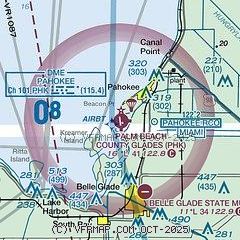
| Sectional chart |
|---|
|
| Airport distance calculator |
|---|
|
|
| Sunrise and sunset |
|---|
|
Times for 22-Jan-2026
| | Local
(UTC-5) | | Zulu
(UTC) |
|---|
| Morning civil twilight | | 06:48 | | 11:48 |
| Sunrise | | 07:13 | | 12:13 |
| Sunset | | 17:56 | | 22:56 |
| Evening civil twilight | | 18:21 | | 23:21 |
|
| Current date and time |
|---|
| Zulu (UTC) | 22-Jan-2026 22:14:07 |
|---|
| Local (UTC-5) | 22-Jan-2026 17:14:07 |
|---|
|
| METAR |
|---|
K2IS
19nm W | 222155Z AUTO 06006KT 10SM BKN085 26/17 A3005 RMK AO2 T02600172
|
KF45
25nm E | 222155Z AUTO 04009KT 10SM SCT023 OVC080 24/21 A3005 RMK AO2
|
KOBE
30nm N | 222155Z AUTO VRB04G10KT 9SM OVC065 24/19 A3004 RMK AO2
|
KPBI
32nm E | 222153Z 03007KT 10SM SCT020 SCT048 BKN075 25/19 A3006 RMK AO2 SLP178 T02500194 $
|
KLNA
35nm E | 222155Z AUTO 02007KT 10SM OVC070 A3006 RMK AO2
|
KSUA
35nm NE | 222147Z 03007KT 7SM FEW015 24/21 A3005
|
|
| TAF |
|---|
KPBI
32nm E | 221720Z 2218/2318 04008KT P6SM VCSH SCT025 OVC050 FM230100 VRB04KT P6SM FEW030 OVC050 FM231500 04007KT P6SM SCT025 BKN050
|
KSUA
35nm NE | 221739Z 2218/2318 03010KT P6SM VCSH BKN020 BKN035 BKN150 FM230200 02006KT P6SM SCT030 SCT250 FM231500 05008KT P6SM SCT025 BKN030 AMD NOT SKED
|
|
| NOTAMs |
|---|
NOTAMs are issued by the DoD/FAA and will open in a separate window not controlled by AirNav.
|
|


