FAA INFORMATION EFFECTIVE 09 JULY 2026
Location
| FAA Identifier: | SUA |
| Lat/Long: | 27-10-54.1170N 080-13-16.6560W
27-10.901950N 080-13.277600W
27.1816992,-80.2212933
(estimated) |
| Elevation: | 16.1 ft. / 4.9 m (surveyed) |
| Variation: | 06W (2010) |
| From city: | 1 mile SE of STUART, FL |
| Time zone: | UTC -4 (UTC -5 during Standard Time) |
| Zip code: | 34996 |
Airport Operations
| Airport use: | Open to the public |
| Activation date: | 07/1943 |
| Control tower: | yes |
| ARTCC: | MIAMI CENTER |
| FSS: | MIAMI FLIGHT SERVICE STATION |
| NOTAMs facility: | MIA (NOTAM-D service available) |
| Attendance: | 0600-2200 |
| Wind indicator: | lighted |
| Segmented circle: | yes |
| Lights: | AFTER 2200 ACTVT REIL RWY 12 & 30; MIRL RWY 07/25 & 12/30- CTAF. |
| Beacon: | white-green (lighted land airport)
Operates sunset to sunrise. |
| International operations: | US CUSTOMS USER FEE ARPT. |
Airport Communications
| CTAF: | 126.6 |
| ATIS: | 134.475 |
| WX AWOS-3: | 134.475 (772-692-7399) |
| STUART GROUND: | 121.7 [0700-2200] |
| STUART TOWER: | 126.6 [0700-2200] |
| PALM BEACH APPROACH: | 132.8 ;SOUTH |
| PALM BEACH DEPARTURE: | 132.8 ;SOUTH |
| CLEARANCE DELIVERY: | 121.025 |
| BRNGR DP: | 123.625 |
| EMERG: | 121.5 243.0 |
| SNDLR DP: | 123.625 |
| TTYLR STAR: | 125.2 |
| VUUDU STAR: | 127.35 |
Nearby radio navigation aids
| VOR radial/distance | | VOR name | | Freq | | Var |
|---|
| PBIr350/31.0 | | PALM BEACH VORTAC | | 115.70 | | 03W |
| NDB name | | Hdg/Dist | | Freq | | Var | | ID |
|---|
| UNITED | | 025/17.5 | | 405 | | 05W | | UTX | ..- - -..- |
Airport Services
| Fuel available: | 100LL JET-A |
| Parking: | hangars and tiedowns |
| Airframe service: | MAJOR |
| Powerplant service: | MAJOR |
| Bottled oxygen: | NONE |
| Bulk oxygen: | NONE |
Runway Information
Runway 12/30
| Dimensions: | 5828 x 100 ft. / 1776 x 30 m |
| Surface: | asphalt/grooved, in good condition |
| Weight bearing capacity: | | PCN 27 /F/B/W/T | | Single wheel: | 65.0 | | Double wheel: | 105.0 | | Double tandem: | 190.0 |
|
| Runway edge lights: | medium intensity |
| Operational restrictions: | ARRESTING GEAR/SYSTEM: ENGINEERED MATERIALS ARRESTING SYSTEM (EMAS) 502 FT IN LENGTH BY 109 FT IN WIDTH AT THE DEPARTURE END OF RWY 12. ARRESTING GEAR/SYSTEM: ENGINEERED MATERIALS ARRESTING SYSTEM (EMAS) 413 FT IN LENGTH BY 109 FT IN WIDTH AT THE DEPARTURE END OF RWY 30. |
| RUNWAY 12 | | RUNWAY 30 |
| Latitude: | 27-10.925050N | | 27-10.592075N |
| Longitude: | 080-13.884193W | | 080-12.875235W |
| Elevation: | 14.7 ft. | | 11.4 ft. |
| Traffic pattern: | left | | left |
| Runway heading: | 116 magnetic, 110 true | | 296 magnetic, 290 true |
| Displaced threshold: | 460 ft. | | no |
| Declared distances: | TORA:5828 TODA:5828 ASDA:5828 LDA:5368 | | TORA:5828 TODA:5828 ASDA:5828 LDA:5828 |
| Markings: | nonprecision, in fair condition | | nonprecision, in fair condition |
| Visual slope indicator: | 4-light PAPI on left (3.00 degrees glide path) | | 4-light PAPI on left (3.00 degrees glide path) |
| Runway end identifier lights: | yes | | yes |
| Touchdown point: | yes, no lights | | yes, no lights |
| Obstructions: | 34 ft. trees, 690 ft. from runway, 260 ft. left of centerline, 14:1 slope to clear
RWY 12 APCH SLP 34:1 TO DSPLCD THLD. | | 28 ft. tree, 1000 ft. from runway, 265 ft. left of centerline, 28:1 slope to clear
RWY 30 APCH SLP 34:1 TO AER. |
Runway 16/34
| Dimensions: | 5000 x 100 ft. / 1524 x 30 m |
| Surface: | asphalt/grooved, in good condition |
| Weight bearing capacity: | | PCN 30 /F/B/X/T | | Single wheel: | 55.0 | | Double wheel: | 90.0 | | Double tandem: | 160.0 |
|
| RUNWAY 16 | | RUNWAY 34 |
| Latitude: | 27-11.310632N | | 27-10.566653N |
| Longitude: | 080-13.298360W | | 080-12.899263W |
| Elevation: | 11.9 ft. | | 11.7 ft. |
| Traffic pattern: | left | | left |
| Runway heading: | 160 magnetic, 154 true | | 340 magnetic, 334 true |
| Displaced threshold: | 336 ft. | | 900 ft. |
| Declared distances: | TORA:5000 TODA:5000 ASDA:4800 LDA:4464 | | TORA:5000 TODA:5000 ASDA:5000 LDA:4100 |
| Markings: | basic, in fair condition | | basic, in fair condition |
| Touchdown point: | yes, no lights | | yes, no lights |
| Obstructions: | 47 ft. trees, 1045 ft. from runway, 245 ft. left of centerline, 17:1 slope to clear
RWY 16 APCH SLP 30:1 TO DSPLCD THLD. | | 22 ft. trees, 200 ft. from runway, 150 ft. left of centerline, 1:1 slope to clear
RWY 34 HAS 22 FT TREES AND 8 FT FENCE 200 FT FROM THE RWY END AND 150 FT LEFT. |
Runway 7/25
| Dimensions: | 4653 x 100 ft. / 1418 x 30 m |
| Surface: | asphalt/grooved, in fair condition |
| Weight bearing capacity: | | PCN 14 /F/B/X/T | | Single wheel: | 58.0 | | Double wheel: | 95.0 | | Double tandem: | 170.0 |
|
| Runway edge lights: | medium intensity |
| RUNWAY 7 | | RUNWAY 25 |
| Latitude: | 27-10.899733N | | 27-11.184407N |
| Longitude: | 080-13.740568W | | 080-12.943095W |
| Elevation: | 15.4 ft. | | 9.9 ft. |
| Traffic pattern: | left | | left |
| Runway heading: | 074 magnetic, 068 true | | 254 magnetic, 248 true |
| Markings: | nonprecision, in fair condition | | nonprecision, in fair condition |
| Visual slope indicator: | 4-light PAPI on left (3.00 degrees glide path) | | 4-light PAPI on left (3.00 degrees glide path) |
| Touchdown point: | yes, no lights | | yes, no lights |
| Obstructions: | 61 ft. tower, 2052 ft. from runway, 75 ft. left of centerline, 30:1 slope to clear | | 49 ft. tree, 1355 ft. from runway, 290 ft. left of centerline, 23:1 slope to clear |
Airport Ownership and Management from official FAA records
| Ownership: | Publicly-owned |
| Owner: | MARTIN COUNTY
2401 SE MONTEREY RD
STUART, FL 34996
Phone 772-221-2374 |
| Manager: | ANDREW MCBEAN
2011 SOUTHEAST AIRPORT ROAD
STUART, FL 34996
Phone 772-221-1458 |
Additional Remarks
| - | ACFT WITH WING SPANS EXCEEDING 79 FT ARE PROHIBITED FROM OPERATING ON TWY 'A' BETWEEN TWY 'C' AND APCH END RY 12 WHEN ACFT WITH WING SPAN EXCEEDING 79 FT IS ON APCH TO, LNDG, OR TAKING OFF RY 12/30. |
| - | BIRDS ON & INVOF ARPT. |
| - | PAPI RESTRICTED TO 7.5 NM WEST OF RWY 25 DUE TO 1548' MSL TOWERS WITHIN 10 DEG OF EXT CNTLN. |
| - | WHEN ATCT CLSD, FOR CD CTC PALM BEACH APCH AT 561-684-9047. |
| - | NOISE SENSITIVE AREAS ALL QUADRANTS. NOISE ABATEMENT PROCEDURES IN EFFECT CALL AMGR 772-221-2374. |
| - | TOUCH & GO OPNS PERMITTED MON-SAT (EXCP NEW YEARS, CHRISTMAS & THANKSGIVING) 0900 UNTIL 2 HRS PAST SS AND ARE LIMITED TO 3 OPNS PER PILOT PER DAY. |
| - | STOP & GO OPNS AND INTXN TKOFS STRONGLY DISCOURAGED AT ALL TIMES. |
| - | STAGE 1 & 2 JET OPNS STRONGLY DISCOURAGED 2300-0800. |
| - | PPR FOR ACFT EXCEEDING RY WT CPTY. |
Instrument Procedures
NOTE: All procedures below are presented as PDF files. If you need a reader for these files, you should download the free Adobe Reader.NOT FOR NAVIGATION. Please procure official charts for flight.
FAA instrument procedures published for use from 09 July 2026 at 0901Z to 06 August 2026 at 0900Z.
STARs - Standard Terminal Arrivals |
|---|
| TTYLR FIVE **NEW** | |
download (169KB) |
| VUUDU TWO (RNAV) **NEW** | |
2 pages:
[1] [2] (475KB) |
| VUUDU TWO (RNAV), CONT.2 **NEW** | |
download (193KB) |
IAPs - Instrument Approach Procedures |
|---|
| RNAV (GPS) RWY 12 | |
download (255KB) |
| RNAV (GPS) RWY 30 | |
download (240KB) |
| NOTE: Special Alternate Minimums apply | |
download (146KB) |
Departure Procedures |
|---|
| SNDLR THREE (RNAV) | |
2 pages:
[1] [2] (311KB) |
| NOTE: Special Take-Off Minimums/Departure Procedures apply | |
download (408KB) |
Other nearby airports with instrument procedures:
06FA - William P Gwinn Airport (17 nm S)
F45 - North Palm Beach County General Aviation Airport (20 nm S)
KFPR - Treasure Coast International Airport (21 nm NW)
KVRB - Vero Beach Regional Airport (30 nm N)
KDJT - President Donald J Trump International Airport (31 nm S)
|
|

Road maps at:
MapQuest
Bing
Google
| Aerial photo |
|---|
WARNING: Photo may not be current or correct
 Photo by Russell Dow
Photo taken 20-Sep-2020
looking north.
Photo by Russell Dow
Photo taken 20-Sep-2020
looking north.
Do you have a better or more recent aerial photo of Witham Field Airport that you would like to share? If so, please send us your photo.
|
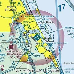
| Sectional chart |
|---|
|
CAUTION: Diagram may not be current
 Download PDF
of official airport diagram from the FAA
| Airport distance calculator |
|---|
|
|
| Sunrise and sunset |
|---|
|
Times for 31-Jul-2026
| | Local
(UTC-4) | | Zulu
(UTC) |
|---|
| Morning civil twilight | | 06:20 | | 10:20 |
| Sunrise | | 06:45 | | 10:45 |
| Sunset | | 20:09 | | 00:09 |
| Evening civil twilight | | 20:34 | | 00:34 |
|
| Current date and time |
|---|
| Zulu (UTC) | 01-Aug-2026 03:05:46 |
|---|
| Local (UTC-4) | 31-Jul-2026 23:05:46 |
|---|
|
| METAR |
|---|
| KSUA | 010255Z AUTO 19004KT 10SM FEW003 BKN060 27/26 A3001 RMK AO2
|
|
| TAF |
|---|
| KSUA | 311949Z 3120/0118 28011KT P6SM VCTS SCT030CB BKN045 OVC080 TEMPO 3120/3121 VRB20G36KT 2SM TSRA BKN030CB FM312300 29005KT P6SM VCSH SCT050 SCT100 BKN250 FM010300 24004KT P6SM SCT040 SCT120 BKN250 FM011400 26007KT P6SM SCT035 BKN150 FM011700 23008KT P6SM SCT035 SCT100 SCT250 AMD NOT SKED
|
|
| NOTAMs |
|---|
NOTAMs are issued by the DoD/FAA and will open in a separate window not controlled by AirNav.
|
|


