FAA INFORMATION EFFECTIVE 16 APRIL 2026
Location
| FAA Identifier: | PWD |
| Lat/Long: | 48-47-25.8560N 104-31-25.4580W
48-47.430933N 104-31.424300W
48.7905156,-104.5237383
(estimated) |
| Elevation: | 2263.9 ft. / 690.0 m (surveyed) |
| Variation: | 10E (2005) |
| From city: | 1 mile NE of PLENTYWOOD, MT |
| Time zone: | UTC -6 (UTC -7 during Standard Time) |
| Zip code: | 59254 |
Airport Operations
| Airport use: | Open to the public |
| Activation date: | 11/1958 |
| Control tower: | no |
| ARTCC: | SALT LAKE CITY CENTER |
| FSS: | GREAT FALLS FLIGHT SERVICE STATION |
| NOTAMs facility: | GTF (NOTAM-D service available) |
| Attendance: | UNATNDD
CALL FOR CONDS (SHERIDAN CTY DISPATCH 406-765-1200), 406-765-7655, OR 406-765-3403). |
| Wind indicator: | lighted |
| Segmented circle: | yes |
| Lights: | PAPI RWY 12 & 30; MIRL RWY 12/30 - OPR DUSK-DAWN; AFT DAWN ACTVT PAPI RWY 12 & 30; MIRL RWY 12/30 - CTAF. |
| Beacon: | white-green (lighted land airport)
Operates sunset to sunrise. |
Airport Communications
| CTAF/UNICOM: | 122.8 |
| WX AWOS-3PT: | 135.025 (406-765-2149) |
- APCH/DEP CTL SVC PRVDD BY SALT LAKE ARTCC (WATFORD CITY RCAG) ON FREQS 126.85/305.2.
Airport Services
| Fuel available: | 100LL
100LL:24 HR SELF SVC CREDIT CARD FUEL FAC. |
| Parking: | hangars and tiedowns |
| Airframe service: | NONE |
| Powerplant service: | NONE |
| Bottled oxygen: | NONE |
| Bulk oxygen: | NONE |
Runway Information
Runway 12/30
| Dimensions: | 3900 x 75 ft. / 1189 x 23 m |
| Surface: | asphalt, in good condition |
| Weight bearing capacity: | |
| Runway edge lights: | medium intensity |
| RUNWAY 12 | | RUNWAY 30 |
| Latitude: | 48-47.546007N | | 48-47.115778N |
| Longitude: | 104-31.798605W | | 104-31.078958W |
| Elevation: | 2251.9 ft. | | 2237.7 ft. |
| Traffic pattern: | left | | left |
| Runway heading: | 122 magnetic, 132 true | | 302 magnetic, 312 true |
| Markings: | nonprecision, in good condition | | nonprecision, in good condition |
| Visual slope indicator: | 2-light PAPI on left (3.00 degrees glide path) | | 2-light PAPI on left (3.00 degrees glide path) |
| Touchdown point: | yes, no lights | | yes, no lights |
Runway 8/26
| Dimensions: | 2951 x 60 ft. / 899 x 18 m |
| Surface: | turf, in fair condition |
| RUNWAY 8 | | RUNWAY 26 |
| Latitude: | 48-47.564932N | | 48-47.561297N |
| Longitude: | 104-31.772383W | | 104-31.038038W |
| Elevation: | 2250.1 ft. | | 2261.1 ft. |
| Traffic pattern: | left | | left |
| Runway heading: | 080 magnetic, 090 true | | 260 magnetic, 270 true |
| Markings: | none | | none |
| Touchdown point: | yes, no lights | | yes, no lights |
Airport Ownership and Management from official FAA records
| Ownership: | Publicly-owned |
| Owner: | CITY OF PLENTWOOD & SHER CTY
100 WEST LAUREL AVE
PLENTYWOOD, MT 59254
Phone 406-765-3403 |
| Manager: | MARY LYNCH
100 W. LAUREL AVE.
PLENTYWOOD, MT 59254
Phone (406) 765-3403 |
Additional Remarks
| - | RWY 8/26 NOT MNTND IN WINTER MONTHS - NO SN REMOVAL. |
| - | FOR CD CTC SALT LAKE ARTCC AT 801-320-2568. |
| - | RWY 12/30 INTMT SN REMOVAL - BE ALERT DURG WINTER MONTHS |
Instrument Procedures
NOTE: All procedures below are presented as PDF files. If you need a reader for these files, you should download the free Adobe Reader.NOT FOR NAVIGATION. Please procure official charts for flight.
FAA instrument procedures published for use from 16 April 2026 at 0901Z to 14 May 2026 at 0900Z.
IAPs - Instrument Approach Procedures |
|---|
| RNAV (GPS) RWY 12 | |
download (215KB) |
| RNAV (GPS) RWY 30 | |
download (215KB) |
| NOTE: Special Alternate Minimums apply | |
download (178KB) |
| NOTE: Special Take-Off Minimums/Departure Procedures apply **CHANGED** | |
download (551KB) |
Other nearby airports with instrument procedures:
9S2 - Scobey Airport (36 nm W)
KXWA - Williston Basin International Airport (44 nm SE)
PO1 - Poplar Municipal Airport (47 nm SW)
D50 - Crosby Municipal Airport (49 nm E)
KOLF - L M Clayton Airport (59 nm SW)
|
|

Road maps at:
MapQuest
Bing
Google
| Aerial photo |
|---|
WARNING: Photo may not be current or correct
 Photo © www.kestrelaerial.com
Photo taken 14-Oct-2007
Photo © www.kestrelaerial.com
Photo taken 14-Oct-2007
Do you have a better or more recent aerial photo of Sher-Wood Airport that you would like to share? If so, please send us your photo.
|
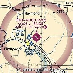
| Sectional chart |
|---|
|
| Airport distance calculator |
|---|
|
|
| Sunrise and sunset |
|---|
|
Times for 04-May-2026
| | Local
(UTC-6) | | Zulu
(UTC) |
|---|
| Morning civil twilight | | 04:58 | | 10:58 |
| Sunrise | | 05:34 | | 11:34 |
| Sunset | | 20:16 | | 02:16 |
| Evening civil twilight | | 20:52 | | 02:52 |
|
| Current date and time |
|---|
| Zulu (UTC) | 04-May-2026 09:52:31 |
|---|
| Local (UTC-6) | 04-May-2026 03:52:31 |
|---|
|
| METAR |
|---|
| KPWD | 040935Z AUTO 33013KT 10SM CLR 03/M03 A2976 RMK AO2
|
|
| TAF |
|---|
KXWA
44nm SE | 040528Z 0406/0506 35022G32KT P6SM OVC150 FM040900 33017G27KT P6SM BKN140 FM041500 33023G35KT P6SM BKN035 FM050200 34017G26KT P6SM BKN090 FM050500 33011KT P6SM SCT100
|
|
| NOTAMs |
|---|
NOTAMs are issued by the DoD/FAA and will open in a separate window not controlled by AirNav.
|
|

