FAA INFORMATION EFFECTIVE 14 MAY 2026
Location
| FAA Identifier: | REI |
| Lat/Long: | 34-05-06.9000N 117-08-47.0000W
34-05.115000N 117-08.783333W
34.0852500,-117.1463889
(estimated) |
| Elevation: | 1574.4 ft. / 479.9 m (surveyed) |
| Variation: | 14E (1995) |
| From city: | 2 miles NE of REDLANDS, CA |
| Time zone: | UTC -7 (UTC -8 during Standard Time) |
| Zip code: | 92374 |
Airport Operations
| Airport use: | Open to the public |
| Activation date: | 02/1947 |
| Control tower: | no |
| ARTCC: | LOS ANGELES CENTER |
| FSS: | RIVERSIDE FLIGHT SERVICE STATION |
| NOTAMs facility: | RAL (NOTAM-D service available) |
| Attendance: | 0800-1700 |
| Pattern altitude: | 2503.4 ft. MSL
TPA - 929 FOR FIXED WING ACFT, N SIDE OF RWY 08/26; 500 FOR HEL, S SIDE OF RWY 08/26. |
| Wind indicator: | lighted |
| Segmented circle: | yes |
| Lights: | ACTVT REIL RWYS 08 & 26; PAPI RWY 08; MIRL RWY 08/26 - CTAF. |
| Beacon: | white-green (lighted land airport)
Operates sunset to sunrise. |
Airport Communications
| CTAF/UNICOM: | 123.05 |
| SOCAL APPROACH: | 127.0 |
| SOCAL DEPARTURE: | 127.0 |
| CLASS C: | 127.0 ;NORTH-NE |
| WX AWOS-3 at SBD (4 nm W): | PHONE 909-382-0067 |
| WX ASOS at RAL (17 nm SW): | 128.8 (951-352-4392) |
| WX AWOS-3 at BNG (18 nm SE): | 134.625 (951-922-4674) |
| WX AWOS-3 at L35 (18 nm NE): | 135.925 (909-585-4033) |
- AUTOMATED UNICOM; 3 CLICKS FOR WX AND ADZY, 4 CLICKS FOR RADIO CHECK.
Nearby radio navigation aids
| VOR radial/distance | | VOR name | | Freq | | Var |
|---|
| RALr049/(17.0) | | RIVERSIDE VOR | | 108.60 | | 14E |
| HDFr352/(18.6) | | HOMELAND VOR | | 112.05 | | 14E |
| PDZr047/21.5 | | PARADISE VORTAC | | 112.20 | | 15E |
| POMr074/31.8 | | POMONA VORTAC | | 110.40 | | 15E |
| VCVr144/32.8 | | VICTORVILLE VOR/DME | | 109.05 | | 14E |
| PSPr277/37.9 | | PALM SPRINGS VORTAC | | 115.50 | | 13E |
| ELBr036/38.1 | | EL TORO VOR/DME | | 117.20 | | 14E |
| NDB name | | Hdg/Dist | | Freq | | Var | | ID |
|---|
| PETIS | | 067/11.1 | | 397 | | 14E | | SB | ... -... |
Airport Services
| Fuel available: | 100LL
100LL:SELF SERVE 100LL FUEL AVBL 24-7. |
| Parking: | tiedowns |
| Airframe service: | MAJOR |
| Powerplant service: | MAJOR |
| Bottled oxygen: | NONE |
| Bulk oxygen: | HIGH/LOW |
Runway Information
Runway 8/26
| Dimensions: | 4504 x 75 ft. / 1373 x 23 m |
| Surface: | asphalt, in good condition |
| Weight bearing capacity: | |
| Runway edge lights: | medium intensity |
| RUNWAY 8 | | RUNWAY 26 |
| Latitude: | 34-05.113665N | | 34-05.118037N |
| Longitude: | 117-09.228998W | | 117-08.336917W |
| Elevation: | 1471.7 ft. | | 1574.4 ft. |
| Traffic pattern: | left | | right |
| Runway heading: | 076 magnetic, 090 true | | 256 magnetic, 270 true |
| Markings: | basic, in good condition | | basic, in good condition |
| Visual slope indicator: | 2-light PAPI on left (3.00 degrees glide path) | | |
| Runway end identifier lights: | yes | | yes |
| Touchdown point: | yes, no lights | | yes, no lights |
| Obstructions: | 4 ft. fence, 300 ft. from runway, 125 ft. left of centerline, 25:1 slope to clear | | 60 ft. trees, 1500 ft. from runway, 120 ft. left of centerline, 22:1 slope to clear |
Airport Ownership and Management from official FAA records
| Ownership: | Publicly-owned |
| Owner: | CITY OF REDLANDS
35 CAJON STREET, SUITE 15A
REDLANDS, CA 92374
Phone 909-798-7668 |
| Manager: | TED RICHARDSON
1745 SESSUMS DRIVE
REDLANDS, CA 92373
Phone 909-557-8520
MAIN NO: 909-557-8520 |
Additional Remarks
| - | AVOID NOISE SENSITIVE AREAS S OF ARPT. |
| - | AEROBATIC ACT NE OF ARPT FROM 3800 FT MSL TO 7800 FT MSL; SEE SPECIAL NOTICE - AEROBATIC OPERATIONS NORTHEAST OF REDLANDS, CA. |
| - | COYOTES AND WATERFOWL ON AND INVOF ARPT. |
| - | FOR CD CTC SOCAL APCH AT 800-448-3724. |
| - | RMN VIGILANT TO SEE AND AVOID LRG AND HVY ACFT WI 5 NM OF REI AND ON SBD RWY 24 APCH WI 1.5 NM EAST THRU NORTH OF RWY; CTN WAKE TURB. ACTVLY MNT REI CTAF AND, IF POSS, SBD ON 119.45. OPR TRANSPONDER AND ADS-B OUT STRONGLY ENCOURAGED. |
| - | TSNT HEL PRKG ON WEST RAMP ONLY. HEL NOSE FACING EAST OR WEST. CALL ARPT MGMT FOR PRKG DTLS AT 909-557-8520. |
Instrument Procedures
NOTE: All procedures below are presented as PDF files. If you need a reader for these files, you should download the free Adobe Reader.NOT FOR NAVIGATION. Please procure official charts for flight.
FAA instrument procedures published for use from 14 May 2026 at 0901Z to 11 June 2026 at 0900Z.
IAPs - Instrument Approach Procedures |
|---|
| RNAV (GPS)-A | |
download (357KB) |
| NOTE: Special Take-Off Minimums/Departure Procedures apply | |
download (351KB) |
Other nearby airports with instrument procedures:
KSBD - San Bernardino International Airport (4 nm W)
KRIV - March Air Reserve Base (13 nm SW)
KRIR - Flabob Airport (14 nm SW)
KRAL - Riverside Airport (17 nm SW)
L35 - Big Bear City Airport (18 nm NE)
|
|

Road maps at:
MapQuest
Bing
Google
| Aerial photo |
|---|
WARNING: Photo may not be current or correct
 Photo courtesy of Steve Bastuba of Skyview Aerial Photo, Inc.
Photo taken 31-Oct-2013
looking west.
Photo courtesy of Steve Bastuba of Skyview Aerial Photo, Inc.
Photo taken 31-Oct-2013
looking west.
Do you have a better or more recent aerial photo of Redlands Municipal Airport that you would like to share? If so, please send us your photo.
|
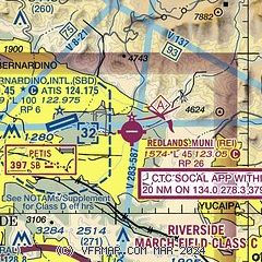
| Sectional chart |
|---|
|
| Airport distance calculator |
|---|
|
|
| Sunrise and sunset |
|---|
|
Times for 26-May-2026
| | Local
(UTC-7) | | Zulu
(UTC) |
|---|
| Morning civil twilight | | 05:13 | | 12:13 |
| Sunrise | | 05:41 | | 12:41 |
| Sunset | | 19:50 | | 02:50 |
| Evening civil twilight | | 20:18 | | 03:18 |
|
| Current date and time |
|---|
| Zulu (UTC) | 26-May-2026 09:45:12 |
|---|
| Local (UTC-7) | 26-May-2026 02:45:12 |
|---|
|
| METAR |
|---|
KSBD
4nm W | 260940Z AUTO 25007KT 10SM OVC030 15/08 A2990 RMK AO2 T01460078
|
KRIV
14nm SW | 260910Z AUTO 00000KT 10SM OVC022 13/11 A2987 RMK AO2 SLP106
|
KRAL
17nm SW | 260853Z AUTO 27004KT 10SM CLR 13/11 A2990 RMK AO2 SLP111 T01330111 58008
|
KL35
18nm NE | 260935Z AUTO 28003KT 6SM HZ CLR 03/M09 A2998 RMK AO2 T00281089 $
|
|
| TAF |
|---|
KSBD
4nm W | 260741Z 2608/2706 VRB04KT P6SM OVC028 FM261800 25007KT P6SM FEW025 FM270100 25012KT P6SM SKC
|
KRIV
14nm SW | 260700Z 2607/2710 VRB06KT 9999 SKC QNH2987INS BECMG 2607/2608 VRB04KT 9999 OVC020 QNH2988INS TEMPO 2608/2615 VCSH OVC015 BECMG 2617/2618 15009KT 9999 BKN030 QNH2986INS BECMG 2618/2619 18009KT 9999 BKN035 QNH2983INS WND 140V240 BECMG 2620/2621 30009KT 9999 SCT040 510006 QNH2976INS WND 260V340 TEMPO 2621/2702 30012G20KT BECMG 2702/2703 18009KT 9999 BKN030 QNH2978INS WND 140V240 BECMG 2705/2706 15006KT 9999 VCSH OVC020 QNH2981INS TX22/2623Z TN12/2613Z
|
|
| NOTAMs |
|---|
NOTAMs are issued by the DoD/FAA and will open in a separate window not controlled by AirNav.
|
|


