FAA INFORMATION EFFECTIVE 16 APRIL 2026
Location
| FAA Identifier: | RAL |
| Lat/Long: | 33-57-06.8000N 117-26-42.4000W
33-57.113333N 117-26.706667W
33.9518889,-117.4451111
(estimated) |
| Elevation: | 818.9 ft. / 249.6 m (surveyed) |
| Variation: | 14E (2000) |
| From city: | 4 miles SW of RIVERSIDE, CA |
| Time zone: | UTC -7 (UTC -8 during Standard Time) |
| Zip code: | 92503 |
Airport Operations
| Airport use: | Open to the public |
| Activation date: | 04/1940 |
| Control tower: | yes |
| ARTCC: | LOS ANGELES CENTER |
| FSS: | RIVERSIDE FLIGHT SERVICE STATION |
| NOTAMs facility: | RAL (NOTAM-D service available) |
| Attendance: | S-S 0600-1600, ALL M-F 0700-1700 |
| Pattern altitude: | TPA LGT ACFT 1000'; JET AND ALL OTHER ACFT 1500'. |
| Wind indicator: | lighted |
| Segmented circle: | yes |
| Lights: | ACTVT MIRL RWYS 09/27 & 16/34; TWY LGTS; HELI PERI LGTS - CTAF. PAPI RWYS 09, 27 & 34 OPR CONSLY. |
| Beacon: | white-green (lighted land airport)
Operates sunset to sunrise. |
Airport Communications
| CTAF: | 121.0 |
| UNICOM: | 122.95 |
| ATIS: | 128.8 |
| WX ASOS: | 128.8 (951-352-4392) |
| RIVERSIDE GROUND: | 124.125 [0700-2000] |
| RIVERSIDE TOWER: | 121.0 257.8 [0700-2000] |
| SOCAL APPROACH: | 135.4 |
| SOCAL DEPARTURE: | 135.4 |
| CLASS C: | 135.4 ;SOUTH-SW |
| SETER STAR: | 127.0 |
| ZIGGY STAR: | 127.0 |
| WX AWOS-3PT at AJO (8 nm SW): | 132.175 (951-340-4764) |
| WX ASOS at CNO (10 nm W): | PHONE 909-393-5823 |
| WX ASOS at ONT (10 nm NW): | PHONE 909-472-0788 |
| WX AWOS-3 at SBD (14 nm NE): | PHONE 909-382-0067 |
| WX AWOS-3P at CCB (15 nm NW): | 119.525 (909-985-4731) |
| WX AWOS-3PT at POC (19 nm NW): | PHONE 909-962-5407 |
Nearby radio navigation aids
| VOR radial/distance | | VOR name | | Freq | | Var |
|---|
| RAL at field | | RIVERSIDE VOR | | 108.60 | | 14E |
| PDZr050/4.7 | | PARADISE VORTAC | | 112.20 | | 15E |
| HDFr295/(16.7) | | HOMELAND VOR | | 112.05 | | 14E |
| POMr099/18.6 | | POMONA VORTAC | | 110.40 | | 15E |
| ELBr027/21.8 | | EL TORO VOR/DME | | 117.20 | | 14E |
| SLIr057/32.0 | | SEAL BEACH VORTAC | | 115.70 | | 15E |
| VCVr170/38.6 | | VICTORVILLE VOR/DME | | 109.05 | | 14E |
| NDB name | | Hdg/Dist | | Freq | | Var | | ID |
|---|
| PETIS | | 198/7.4 | | 397 | | 14E | | SB | ... -... |
Airport Services
| Fuel available: | 100LL JET-A
100LL:FOR FUEL AFTER HRS CALL (951) 321-0091. |
| Parking: | tiedowns |
| Airframe service: | MAJOR |
| Powerplant service: | MAJOR |
| Bottled oxygen: | HIGH/LOW |
| Bulk oxygen: | HIGH/LOW |
Runway Information
Runway 9/27
| Dimensions: | 5401 x 100 ft. / 1646 x 30 m |
| Surface: | asphalt, in good condition |
| Weight bearing capacity: | | Single wheel: | 48.0 | | Double wheel: | 70.0 | | Double tandem: | 110.0 |
|
| Runway edge lights: | medium intensity |
| RUNWAY 9 | | RUNWAY 27 |
| Latitude: | 33-57.233243N | | 33-57.032202N |
| Longitude: | 117-27.118152W | | 117-26.077353W |
| Elevation: | 760.4 ft. | | 818.6 ft. |
| Traffic pattern: | left | | left |
| Runway heading: | 089 magnetic, 103 true | | 269 magnetic, 283 true |
| Markings: | precision, in good condition | | nonprecision, in good condition |
| Visual slope indicator: | 4-light PAPI on left (3.00 degrees glide path) | | 4-light PAPI on left (3.00 degrees glide path) |
| Runway end identifier lights: | no | | no |
| Touchdown point: | yes, no lights | | yes, no lights |
| Instrument approach: | ILS | | |
| Obstructions: | none | | 37 ft. gnd, 1155 ft. from runway, 520 ft. right of centerline, 25:1 slope to clear
SUPPLEMENTAL WIND CONE 0 FT FM THR 350 FT S OF RY CNTRLN. |
Runway 16/34
| Dimensions: | 2850 x 50 ft. / 869 x 15 m |
| Surface: | asphalt, in fair condition |
| Weight bearing capacity: | | Single wheel: | 40.0, LTD BY ARPT OPERATOR TO 12500 LBS SINGLE WHEEL GEAR. | | Double wheel: | 50.0 | | Double tandem: | 80.0 |
|
| Runway edge lights: | medium intensity |
| RUNWAY 16 | | RUNWAY 34 |
| Latitude: | 33-57.309280N | | 33-56.839580N |
| Longitude: | 117-26.918280W | | 117-26.903997W |
| Elevation: | 774.5 ft. | | 750.6 ft. |
| Traffic pattern: | right | | left |
| Runway heading: | 165 magnetic, 179 true | | 345 magnetic, 359 true |
| Markings: | basic, in good condition | | basic, in good condition |
| Visual slope indicator: | | | 2-light PAPI on left (3.00 degrees glide path) |
| Runway end identifier lights: | no | | no |
| Touchdown point: | yes, no lights | | yes, no lights |
Helipad H1
| Dimensions: | 60 x 60 ft. / 18 x 18 m |
| Surface: | asphalt, in good condition |
| Runway edge lights: | PERI |
| Latitude: | 33-57.105333N | | |
| Longitude: | 117-26.857000W | | |
| Elevation: | 766.0 ft. | | |
| Traffic pattern: | left | | left |
Airport Ownership and Management from official FAA records
| Ownership: | Publicly-owned |
| Owner: | CITY OF RIVERSIDE
6951 FLIGHT ROAD
RIVERSIDE, CA 92504
Phone 951-351-6113 |
| Manager: | DR. DANIEL PRATHER
6951 FLIGHT ROAD
RIVERSIDE, CA 92504
Phone 951-351-6113
DPRATHER@RIVERSIDECA.GOV |
Additional Remarks
| - | ACFT DEP RYS 09 & 27 NOT VSBL TO ACFT AT OTHER END OF RY. |
| - | NUMEROUS POWER LINES 1,780 - 2,887 FEET NORTH OF RY 16 THLD AT OR BLO 80 FEET AGL. |
| - | S 1,400 FT OF RWY 34 & TWY J AND S 500 FT OF TWY B NOT VSB FM TWR. |
| - | TWY E STEEP SLOPE |
| - | TWY L NOT VSB FM TWR. |
| - | FOR CD WHEN ATCT CLSD CTC SOCAL APCH AT 800-448-3724. |
| - | TURBINE ENG ACFT: PREFERRED ROLLING TKOF FOR NOISE MGMT. |
| - | RWY 27 DEP: FOR NOISE MGMT, AFTER DEP TURN RIGHT 10 DEGS; ASSUME CRS AFTER RCHG 1500 MSL. |
| - | NO HIGH PWR ENG MAINT RUNS BTN 2200-0700 LCL. |
| - | FOR NOISE MGMT: NO TURNS BFR ARPT BDRY AND 1500 MSL. |
| - | RWY 27: -20 FT DITCH 50 FT FM RWY 27 THLD. |
| - | POWER PLANT 3,000 FT NORTH OF RY 16 THLD PRODUCING THERMAL PLUME, AVOIDANCE ADZD, |
Instrument Procedures
NOTE: All procedures below are presented as PDF files. If you need a reader for these files, you should download the free Adobe Reader.NOT FOR NAVIGATION. Please procure official charts for flight.
FAA instrument procedures published for use from 16 April 2026 at 0901Z to 14 May 2026 at 0900Z.
STARs - Standard Terminal Arrivals |
|---|
| SETER FIVE **CHANGED** | |
download (244KB) |
| ZIGGY EIGHT **CHANGED** | |
2 pages:
[1] [2] (401KB) |
IAPs - Instrument Approach Procedures |
|---|
| ILS OR LOC RWY 09 | |
download (336KB) |
| RNAV (GPS) RWY 09 | |
download (306KB) |
| RNAV (GPS) RWY 27 | |
download (295KB) |
| VOR RWY 09 | |
download (260KB) |
| VOR-A | |
download (282KB) |
| NOTE: Special Alternate Minimums apply | |
download (139KB) |
|
|---|
| RIVERSIDE TWO (OBSTACLE) | |
download (326KB) |
| NOTE: Special Take-Off Minimums/Departure Procedures apply | |
download (352KB) |
Other nearby airports with instrument procedures:
KRIR - Flabob Airport (3 nm NE)
KAJO - Corona Municipal Airport (8 nm SW)
KCNO - Chino Airport (10 nm W)
KONT - Ontario International Airport (10 nm NW)
KRIV - March Air Reserve Base (10 nm SE)
KSBD - San Bernardino International Airport (14 nm NE)
KCCB - Cable Airport (15 nm NW)
KREI - Redlands Municipal Airport (17 nm NE)
KPOC - Brackett Field Airport (19 nm NW)
|
|

Road maps at:
MapQuest
Bing
Google
| Aerial photo |
|---|
WARNING: Photo may not be current or correct
 Photo by Fred Emmert AirViews.com
Photo taken 10-Dec-2014
looking northeast.
Photo by Fred Emmert AirViews.com
Photo taken 10-Dec-2014
looking northeast.
Do you have a better or more recent aerial photo of Riverside Airport that you would like to share? If so, please send us your photo.
|
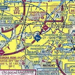
| Sectional chart |
|---|
|
 Download PDF
of official airport diagram from the FAA
| Airport distance calculator |
|---|
|
|
| Sunrise and sunset |
|---|
|
Times for 11-May-2026
| | Local
(UTC-7) | | Zulu
(UTC) |
|---|
| Morning civil twilight | | 05:25 | | 12:25 |
| Sunrise | | 05:52 | | 12:52 |
| Sunset | | 19:40 | | 02:40 |
| Evening civil twilight | | 20:07 | | 03:07 |
|
| Current date and time |
|---|
| Zulu (UTC) | 12-May-2026 01:54:21 |
|---|
| Local (UTC-7) | 11-May-2026 18:54:21 |
|---|
|
| METAR |
|---|
| KRAL | 120053Z 27014KT 10SM CLR 32/09 A2989 RMK AO2 SLP104 T03220094
|
KAJO
8nm SW | 120056Z AUTO A2989 RMK AO2 SLPNO FZRANO $
|
KCNO
9nm W | 120053Z 24013KT 10SM CLR 32/12 A2990 RMK AO2 SLP118 T03170117 $
|
KONT
9nm NW | 120053Z 25011G18KT 10SM CLR 33/08 A2989 RMK AO2 SLP107 T03280083 $
|
KRIV
10nm SE | 120055Z AUTO 31012KT 10SM CLR 32/00 A2990 RMK AO2 SLP113 T03240004
|
KSBD
14nm NE | 120056Z 23012KT 10SM CLR 34/02 A2991
|
KCCB
15nm NW | 119.525 909-985-4731
120135Z AUTO 26013KT 10SM CLR 30/08 A2991 RMK AO2
|
KPOC
18nm NW | 120047Z 26014KT 10SM CLR 31/09 A2992
|
|
| TAF |
|---|
KONT
9nm NW | 111734Z 1118/1224 VRB04KT P6SM SKC FM112100 25011G18KT P6SM SKC FM120500 VRB05KT P6SM SKC TEMPO 1212/1216 3SM BR BKN004 FM122000 24011G18KT P6SM SKC
|
KRIV
10nm SE | 111200Z 1112/1218 29004KT 9999 SKC QNH2994INS BECMG 1114/1115 VRB04KT 9999 SKC QNH2996INS BECMG 1119/1120 32009KT 9999 SKC 510005 QNH2991INS TEMPO 1121/1201 32012G20KT BECMG 1201/1202 31006KT 9999 SKC QNH2991INS BECMG 1208/1209 29004KT 9000 HZ SKC QNH2992INS BECMG 1215/1216 32004KT 9999 NSW SKC QNH2994INS TX35/1122Z TN10/1113Z
|
KSBD
14nm NE | 111734Z 1118/1218 VRB04KT P6SM SKC FM112200 25010KT P6SM SKC FM120500 VRB05KT P6SM SKC
|
|
| NOTAMs |
|---|
NOTAMs are issued by the DoD/FAA and will open in a separate window not controlled by AirNav.
|
|


