FAA INFORMATION EFFECTIVE 14 MAY 2026
Location
| FAA Identifier: | CNO |
| Lat/Long: | 33-58-29.2055N 117-38-11.3382W
33-58.486758N 117-38.188970W
33.9747793,-117.6364828
(estimated) |
| Elevation: | 650 ft. / 198.1 m (surveyed) |
| Variation: | 14E (1980) |
| From city: | 3 miles SE of CHINO, CA |
| Time zone: | UTC -7 (UTC -8 during Standard Time) |
| Zip code: | 91710 |
Airport Operations
| Airport use: | Open to the public |
| Activation date: | 06/1941 |
| Control tower: | yes |
| ARTCC: | LOS ANGELES CENTER |
| FSS: | RIVERSIDE FLIGHT SERVICE STATION |
| NOTAMs facility: | CNO (NOTAM-D service available) |
| Attendance: | CONTINUOUS |
| Pattern altitude: | 1400 ft. MSL
TWIN ENGINE TPA 1350 FT AGL. |
| Wind indicator: | lighted |
| Segmented circle: | no |
| Lights: | WHEN ATCT CLSD MIRL RY 03/21, HIRL RY 08L/26R, MIRL 08R/26L ARE TURNED ON. PAPI RYS 26R, 08R, 26L, 03, 21 AND REIL RYS 03 & 21 OPER CONTINUOUSLY. |
| Beacon: | white-green (lighted land airport)
Operates sunset to sunrise. |
Airport Communications
| CTAF: | 118.5 |
| UNICOM: | 122.95 |
| ATIS: | 125.85 |
| WX ASOS: | PHONE 909-393-5823 |
| CHINO GROUND: | 121.6 [0700-2100] |
| CHINO TOWER: | 118.5 120.125 ;RWY 08R/26L [0700-2100] |
| SOCAL APPROACH: | 135.4 |
| SOCAL DEPARTURE: | 135.4 |
| CLASS C: | 135.4 ;SOUTH-SW |
| IC: | 135.4 |
| SETER STAR: | 127.0 |
| ZIGGY STAR: | 127.0 |
| WX AWOS-3PT at AJO (5 nm S): | 132.175 (951-340-4764) |
| WX ASOS at ONT (5 nm N): | PHONE 909-472-0788 |
| WX AWOS-3P at CCB (9 nm N): | 119.525 (909-985-4731) |
| WX ASOS at RAL (10 nm E): | 128.8 (951-352-4392) |
| WX AWOS-3PT at POC (10 nm NW): | PHONE 909-962-5407 |
| WX ASOS at FUL (18 nm W): | PHONE 714-870-1372 |
Nearby radio navigation aids
| VOR radial/distance | | VOR name | | Freq | | Var |
|---|
| PDZr288/6.3 | | PARADISE VORTAC | | 112.20 | | 15E |
| RALr263/(9.4) | | RIVERSIDE VOR | | 108.60 | | 14E |
| POMr115/9.7 | | POMONA VORTAC | | 110.40 | | 15E |
| ELBr001/18.5 | | EL TORO VOR/DME | | 117.20 | | 14E |
| SLIr046/23.8 | | SEAL BEACH VORTAC | | 115.70 | | 15E |
| HDFr284/(25.4) | | HOMELAND VOR | | 112.05 | | 14E |
| VCVr184/39.1 | | VICTORVILLE VOR/DME | | 109.05 | | 14E |
| LAXr071/39.7 | | LOS ANGELES VORTAC | | 113.60 | | 15E |
| NDB name | | Hdg/Dist | | Freq | | Var | | ID |
|---|
| PETIS | | 236/14.3 | | 397 | | 14E | | SB | ... -... |
Airport Services
| Fuel available: | 100LL JET-A
100LL:SELF-SERVICE FUEL AVBL 24 HRS. |
| Parking: | hangars and tiedowns |
| Airframe service: | MAJOR |
| Powerplant service: | MAJOR |
| Bottled oxygen: | NONE |
| Bulk oxygen: | LOW |
Runway Information
Runway 8R/26L
| Dimensions: | 7000 x 150 ft. / 2134 x 46 m |
| Surface: | asphalt/grooved, in good condition |
| Weight bearing capacity: | | Single wheel: | 75.0 | | Double wheel: | 150.0 | | Double tandem: | 215.0 |
|
| Runway edge lights: | medium intensity |
| RUNWAY 8R | | RUNWAY 26L |
| Latitude: | 33-58.410758N | | 33-58.422365N |
| Longitude: | 117-38.803620W | | 117-37.418470W |
| Elevation: | 619.5 ft. | | 636.5 ft. |
| Traffic pattern: | right | | left |
| Runway heading: | 075 magnetic, 089 true | | 255 magnetic, 269 true |
| Markings: | nonprecision, in good condition | | nonprecision, in good condition |
| Visual slope indicator: | 4-light PAPI on left (3.00 degrees glide path) | | 4-light PAPI on left (3.00 degrees glide path) |
| Touchdown point: | yes, no lights | | yes, no lights |
| Obstructions: | none | | 55 ft. trees, 1320 ft. from runway, 75 ft. left of centerline, 20:1 slope to clear |
Runway 3/21
| Dimensions: | 4919 x 150 ft. / 1499 x 46 m |
| Surface: | asphalt, in good condition |
| Weight bearing capacity: | | Single wheel: | 21.0 | | Double wheel: | 130.0 | | Dual double tandem: | 50.0 |
|
| Runway edge lights: | medium intensity |
| RUNWAY 3 | | RUNWAY 21 |
| Latitude: | 33-58.237833N | | 33-58.817152N |
| Longitude: | 117-38.506530W | | 117-37.825252W |
| Elevation: | 610.4 ft. | | 649.7 ft. |
| Traffic pattern: | right | | left |
| Runway heading: | 030 magnetic, 044 true | | 210 magnetic, 224 true |
| Markings: | nonprecision, in good condition | | nonprecision, in good condition |
| Visual slope indicator: | 4-light PAPI on left (3.00 degrees glide path) | | 4-light PAPI on left (3.00 degrees glide path) |
| Runway end identifier lights: | yes | | yes |
| Touchdown point: | yes, no lights | | yes, no lights |
Runway 8L/26R
| Dimensions: | 4858 x 150 ft. / 1481 x 46 m |
| Surface: | asphalt, in good condition |
| Weight bearing capacity: | |
| Runway edge lights: | high intensity |
| RUNWAY 8L | | RUNWAY 26R |
| Latitude: | 33-58.542568N | | 33-58.550752N |
| Longitude: | 117-38.805298W | | 117-37.843952W |
| Elevation: | 617.2 ft. | | 636.1 ft. |
| Traffic pattern: | right | | left |
| Runway heading: | 075 magnetic, 089 true | | 255 magnetic, 269 true |
| Markings: | basic, in good condition | | precision, in good condition |
| Visual slope indicator: | 4-light PAPI on left (3.00 degrees glide path) | | 4-light PAPI on left (3.00 degrees glide path) |
| Runway end identifier lights: | no | | no |
| Touchdown point: | yes, no lights | | yes, no lights |
| Instrument approach: | | | ILS |
| Obstructions: | 65 ft. trees, 1571 ft. from runway, 140 ft. left of centerline, 21:1 slope to clear | | 60 ft. trees, 2150 ft. from runway, 250 ft. left of centerline, 32:1 slope to clear |
Airport Ownership and Management from official FAA records
| Ownership: | Publicly-owned |
| Owner: | COUNTY OF SAN BERNARDINO
268 W. HOSPITALITY LANE, SUITE 302
CHINO, CA 91710-9091
Phone 909-387-8810 |
| Manager: | GREGORY ZARCO
7000 MERRILL AVE, BOX 1
CHINO, CA 91710-0831
Phone 909-465-5202 |
Additional Remarks
| - | RADIO CONTROLLED AIRCRAFT ACTIVITY BELOW 400 FT AGL 2.5 NM SOUTH OF AIRPORT |
| - | BIRDS AND WILDLIFE ON AND INVOF ARPT. |
| - | FOR CD WHEN ATCT CLSD CTC SOCAL APCH AT 800-448-3724. |
Instrument Procedures
NOTE: All procedures below are presented as PDF files. If you need a reader for these files, you should download the free Adobe Reader.NOT FOR NAVIGATION. Please procure official charts for flight.
FAA instrument procedures published for use from 14 May 2026 at 0901Z to 11 June 2026 at 0900Z.
STARs - Standard Terminal Arrivals |
|---|
| SETER FIVE | |
download (244KB) |
| ZIGGY EIGHT | |
2 pages:
[1] [2] (401KB) |
IAPs - Instrument Approach Procedures |
|---|
| ILS OR LOC RWY 26R | |
download (319KB) |
| RNAV (GPS) RWY 26R | |
download (283KB) |
| VOR RWY 26R | |
download (289KB) |
| NOTE: Special Alternate Minimums apply | |
download (118KB) |
| NOTE: Special Take-Off Minimums/Departure Procedures apply | |
download (132KB) |
Other nearby airports with instrument procedures:
KAJO - Corona Municipal Airport (5 nm S)
KONT - Ontario International Airport (5 nm N)
KCCB - Cable Airport (9 nm N)
KRAL - Riverside Airport (10 nm E)
KPOC - Brackett Field Airport (10 nm NW)
KRIR - Flabob Airport (11 nm E)
KFUL - Fullerton Municipal Airport (18 nm W)
KRIV - March Air Reserve Base (20 nm E)
|
|

Road maps at:
MapQuest
Bing
Google
| Aerial photo |
|---|
WARNING: Photo may not be current or correct
 Photo by focalfloght.com
Photo taken 24-May-2019
looking northeast.
Photo by focalfloght.com
Photo taken 24-May-2019
looking northeast.
Do you have a better or more recent aerial photo of Chino Airport that you would like to share? If so, please send us your photo.
|
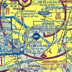
| Sectional chart |
|---|
|
CAUTION: Diagram may not be current
 Download PDF
of official airport diagram from the FAA
| Airport distance calculator |
|---|
|
|
| Sunrise and sunset |
|---|
|
Times for 31-May-2026
| | Local
(UTC-7) | | Zulu
(UTC) |
|---|
| Morning civil twilight | | 05:13 | | 12:13 |
| Sunrise | | 05:42 | | 12:42 |
| Sunset | | 19:55 | | 02:55 |
| Evening civil twilight | | 20:23 | | 03:23 |
|
| Current date and time |
|---|
| Zulu (UTC) | 31-May-2026 07:21:49 |
|---|
| Local (UTC-7) | 31-May-2026 00:21:49 |
|---|
|
| METAR |
|---|
| KCNO | 310653Z AUTO 27005KT 10SM CLR 16/12 A2995 RMK AO2 SLP138 T01610117
|
KAJO
5nm S | 310656Z AUTO 00000KT 10SM CLR 14/12 A2995 RMK AO2 SLPNO T01390117
|
KONT
5nm NE | 310653Z 23003KT 10SM CLR 18/12 A2994 RMK AO2 SLP128 T01830117 $
|
KCCB
9nm N | 119.525 909-985-4731
310655Z AUTO 00000KT 10SM 17/11 A2995 RMK AO2
|
KRAL
9nm E | 310653Z AUTO 00000KT 10SM CLR 18/11 A2995 RMK AO2 SLP126 T01830111
|
KPOC
10nm NW | 310347Z 26005KT 10SM CLR 20/12 A2995 RMK LAST
|
KFUL
18nm W | 310653Z AUTO 13003KT 10SM CLR 18/14 A2993 RMK AO2 SLP133 T01780144
|
KRIV
20nm E | 310555Z AUTO 00000KT 10SM CLR 18/11 A2995 RMK AO2 SLP132 T01820105 10276 20181 52009
|
KEMT
20nm W | 310145Z 20009KT 10SM CLR 23/12 A2992
|
|
| TAF |
|---|
KONT
5nm NE | 310520Z 3106/0112 VRB04KT P6SM SKC FM311900 25011KT P6SM SKC FM010500 VRB04KT P6SM SKC
|
KRIV
20nm E | 310410Z 3104/0110 31006KT 9999 SKC QNH2993INS BECMG 3105/3106 VRB04KT 9999 SKC QNH2990INS BECMG 3117/3118 31006KT 9999 SKC QNH2988INS BECMG 3119/3120 32009KT 9999 FEW100 510006 QNH2983INS TEMPO 3122/0101 32012G20KT BECMG 0102/0103 31006KT 9999 FEW300 QNH2986INS BECMG 0105/0106 VRB04KT 9999 FEW300 QNH2988INS TX31/3122Z TN09/3113Z
|
|
| NOTAMs |
|---|
NOTAMs are issued by the DoD/FAA and will open in a separate window not controlled by AirNav.
|
|


