FAA INFORMATION EFFECTIVE 14 MAY 2026
Location
| FAA Identifier: | RTS |
| Lat/Long: | 39-40-05.4370N 119-52-35.1827W
39-40.090617N 119-52.586378W
39.6681769,-119.8764396
(estimated) |
| Elevation: | 5050.1 ft. / 1539.3 m (surveyed) |
| Variation: | 16E (2000) |
| From city: | 10 miles NW of RENO, NV |
| Time zone: | UTC -7 (UTC -8 during Standard Time) |
| Zip code: | 89506 |
Airport Operations
| Airport use: | Open to the public |
| Activation date: | 08/1943 |
| Control tower: | no |
| ARTCC: | OAKLAND CENTER |
| FSS: | RENO FLIGHT SERVICE STATION |
| NOTAMs facility: | RTS (NOTAM-D service available) |
| Attendance: | MONDAY - FRIDAY 0700-1630 |
| Pattern altitude: | 5850.1 ft. MSL
TPA-6246(1200) HEAVY/HIGH PERFORMANCE ACFT. |
| Wind indicator: | lighted |
| Segmented circle: | yes |
| Lights: | ACTVT MALSR RWY 32; REIL RWY 14; HIRL RWY 14/32 - CTAF. PAPI RWY 32 ON CONSLY. |
| Beacon: | white-green (lighted land airport)
Operates sunset to sunrise. |
Airport Communications
| CTAF/UNICOM: | 122.7 |
| WX AWOS-3: | 135.175 (775-677-0589) |
| NORCAL APPROACH: | 126.3 |
| NORCAL DEPARTURE: | 126.3 |
| WX ASOS at RNO (11 nm SE): | 135.8 (775-432-6755) |
Nearby radio navigation aids
| VOR radial/distance | | VOR name | | Freq | | Var |
|---|
| FMGr293/13.1 | | MUSTANG VORTAC | | 117.90 | | 16E |
| SWRr016/34.5 | | PALISADES VOR/DME | | 113.20 | | 16E |
| AHCr144/38.1 | | AMEDEE VOR/DME | | 109.00 | | 17E |
Airport Services
| Fuel available: | 100LL JET-A |
| Parking: | hangars and tiedowns |
| Airframe service: | MAJOR |
| Powerplant service: | MAJOR |
| Bottled oxygen: | HIGH |
| Bulk oxygen: | HIGH |
Runway Information
Runway 14/32
| Dimensions: | 9000 x 150 ft. / 2743 x 46 m |
| Surface: | asphalt/grooved, in good condition |
| Weight bearing capacity: | |
| Runway edge lights: | high intensity |
| RUNWAY 14 | | RUNWAY 32 |
| Latitude: | 39-41.003270N | | 39-39.675567N |
| Longitude: | 119-52.895617W | | 119-52.042517W |
| Elevation: | 5043.5 ft. | | 5043.8 ft. |
| Traffic pattern: | left | | right |
| Runway heading: | 137 magnetic, 153 true | | 317 magnetic, 333 true |
| Displaced threshold: | no | | 1200 ft. |
| Declared distances: | | | LDA:7800 |
| Markings: | nonprecision, in good condition | | precision, in good condition |
| Visual slope indicator: | 4-light PAPI on left (3.00 degrees glide path)
PAPI OTS INDEFLY. | | 4-light PAPI on left (3.00 degrees glide path) |
| Approach lights: | | | MALSR: 1,400 foot medium intensity approach lighting system with runway alignment indicator lights |
| Runway end identifier lights: | yes | | no |
| Touchdown point: | yes, no lights | | yes, no lights |
| Instrument approach: | | | ILS/DME |
Runway 8/26
| Dimensions: | 7608 x 150 ft. / 2319 x 46 m |
| Surface: | asphalt/grooved, in excellent condition |
| Weight bearing capacity: | |
| Runway edge lights: | high intensity |
| RUNWAY 8 | | RUNWAY 26 |
| Latitude: | 39-39.860743N | | 39-39.731842N |
| Longitude: | 119-53.531307W | | 119-51.918998W |
| Elevation: | 4991.8 ft. | | 5050.1 ft. |
| Traffic pattern: | left | | right |
| Runway heading: | 080 magnetic, 096 true | | 260 magnetic, 276 true |
| Declared distances: | TORA:6956 TODA:6956 LDA:6956 | | LDA:7294 |
| Markings: | nonprecision, in good condition | | nonprecision, in good condition |
| Visual slope indicator: | 4-light PAPI on left (4.00 degrees glide path)
PAPI UNUSBL BYD 5 DEGS RIGHT OF CNTRLN. | | 4-light PAPI on left (3.00 degrees glide path) |
| Runway end identifier lights: | yes | | yes |
| Touchdown point: | yes, no lights | | yes, no lights |
Airport Ownership and Management from official FAA records
| Ownership: | Publicly-owned |
| Owner: | RENO TAHOE ARPT AUTH
P.O. BOX 12490
RENO, NV 89510
Phone 775-328-6400 |
| Manager: | SCOTT GORDON
4895 TEXAS AVE
RENO, NV 89506
Phone 775-328-6573 |
Additional Remarks
| - | FOR CD CTC NORCAL APCH AT 916-361-0596. |
| - | FUEL AVBL H24 - 775-530-7164 OR 122.775. |
| - | RNG HEL OPS INVOF ARPT; BALLOON OPS NW QUAD; TANKER & FIRE OPS INVOF ARPT DURG FIRE SEASON. |
| - | COLD TEMPERATURE AIRPORT. ALTITUDE CORRECTION REQUIRED AT OR BELOW -15C. |
Instrument Procedures
NOTE: All procedures below are presented as PDF files. If you need a reader for these files, you should download the free Adobe Reader.NOT FOR NAVIGATION. Please procure official charts for flight.
FAA instrument procedures published for use from 14 May 2026 at 0901Z to 11 June 2026 at 0900Z.
IAPs - Instrument Approach Procedures |
|---|
| ILS OR LOC RWY 32 | |
download (448KB) |
| RNAV (GPS) RWY 32 | |
download (358KB) |
|
|---|
| STEAD ONE (OBSTACLE) | |
download (257KB) |
| NOTE: Special Take-Off Minimums/Departure Procedures apply | |
download (391KB) |
Other nearby airports with instrument procedures:
KRNO - Reno/Tahoe International Airport (11 nm SE)
O02 - Nervino Airport (24 nm W)
KTRK - Truckee-Tahoe Airport (24 nm SW)
KCXP - Carson City Airport (29 nm S)
KSPZ - Silver Springs Airport (33 nm SE)
|
|

Road maps at:
MapQuest
Bing
Google
| Aerial photo |
|---|
WARNING: Photo may not be current or correct
 Photo taken 15-Sep-2006
Do you have a better or more recent aerial photo of Reno/Stead Airport that you would like to share? If so, please send us your photo.
|
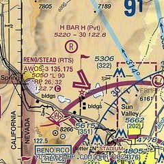
| Sectional chart |
|---|
|
| Airport distance calculator |
|---|
|
|
| Sunrise and sunset |
|---|
|
Times for 05-Jun-2026
| | Local
(UTC-7) | | Zulu
(UTC) |
|---|
| Morning civil twilight | | 05:01 | | 12:01 |
| Sunrise | | 05:33 | | 12:33 |
| Sunset | | 20:23 | | 03:23 |
| Evening civil twilight | | 20:55 | | 03:55 |
|
| Current date and time |
|---|
| Zulu (UTC) | 05-Jun-2026 09:48:29 |
|---|
| Local (UTC-7) | 05-Jun-2026 02:48:29 |
|---|
|
| METAR |
|---|
| KRTS | 050935Z AUTO 35005KT 10SM CLR 13/01 A3005 RMK AO2
|
KRNO
12nm SE | 050855Z 28006KT 10SM CLR 18/01 A3002 RMK AO2 SLP108 T01830011 58005 $
|
|
| TAF |
|---|
KRNO
12nm SE | 050520Z 0506/0606 VRB04KT P6SM FEW200 FM051300 VRB02KT P6SM SCT200 FM052100 30008G17KT P6SM SCT200 FM052300 29018G27KT P6SM SCT200
|
|
| NOTAMs |
|---|
NOTAMs are issued by the DoD/FAA and will open in a separate window not controlled by AirNav.
|
|

