FAA INFORMATION EFFECTIVE 14 MAY 2026
Location
| FAA Identifier: | RVJ |
| Lat/Long: | 32-03-34.1540N 082-09-12.8760W
32-03.569233N 082-09.214600W
32.0594872,-82.1535767
(estimated) |
| Elevation: | 195.6 ft. / 59.6 m (surveyed) |
| Variation: | 06W (2010) |
| From city: | 3 miles SW of REIDSVILLE, GA |
| Time zone: | UTC -4 (UTC -5 during Standard Time) |
| Zip code: | 30453 |
Airport Operations
| Airport use: | Open to the public |
| Activation date: | 06/1974 |
| Control tower: | no |
| ARTCC: | JACKSONVILLE CENTER |
| FSS: | MACON FLIGHT SERVICE STATION |
| NOTAMs facility: | MCN (NOTAM-D service available) |
| Attendance: | UNATNDD |
| Wind indicator: | lighted |
| Segmented circle: | yes |
| Lights: | ACTVT PAPI RYS 11 & 29, MIRL RY 11/29 PRESET LOW INTS DUSK-0230; TO INCR INTS & ACTVT AFTER 0230 - CTAF. |
| Beacon: | white-green (lighted land airport)
Operates sunset to sunrise. |
Airport Communications
| CTAF: | 122.9 |
| WX AWOS-3PT: | 128.325 (912-557-0011) |
| WX AWOS-3 at VDI (14 nm NW): | 119.925 (912-538-0219) |
| WX AWOS-3 at CWV (17 nm NE): | 120.075 (912-739-3768) |
| WX AWOS-3PT at MHP (19 nm N): | 120.3 (912-685-2729) |
- APCH/DEP SVC PRVDD BY JACKSONVILLE ARTCC ON FREQS 127.575/269.025 (ALMA RCAG).
Nearby radio navigation aids
| NDB name | | Hdg/Dist | | Freq | | Var | | ID |
|---|
| ONYUN | | 149/12.3 | | 372 | | 06W | | UQN | ..- --.- -. |
| BULLO | | 234/32.8 | | 407 | | 05W | | BZQ | -... --.. --.- |
Airport Services
| Fuel available: | 100LL JET-A
100LL:FUEL 24 HR CREDIT CARD SVC AVBL. |
| Parking: | tiedowns |
| Airframe service: | NONE |
| Powerplant service: | NONE |
| Bottled oxygen: | NONE |
| Bulk oxygen: | NONE |
Runway Information
Runway 11/29
| Dimensions: | 5003 x 75 ft. / 1525 x 23 m |
| Surface: | asphalt, in good condition |
| Weight bearing capacity: | |
| Runway edge lights: | medium intensity |
| RUNWAY 11 | | RUNWAY 29 |
| Latitude: | 32-03.697023N | | 32-03.441427N |
| Longitude: | 082-09.675212W | | 082-08.754000W |
| Elevation: | 164.0 ft. | | 195.4 ft. |
| Traffic pattern: | left | | left |
| Runway heading: | 114 magnetic, 108 true | | 294 magnetic, 288 true |
| Markings: | nonprecision, in fair condition | | nonprecision, in fair condition |
| Visual slope indicator: | 2-light PAPI on left (3.00 degrees glide path) | | 2-light PAPI on left (3.00 degrees glide path) |
| Touchdown point: | yes, no lights | | yes, no lights |
| Obstructions: | 38 ft. tree, 1444 ft. from runway, 600 ft. right of centerline, 32:1 slope to clear | | 51 ft. trees, 1281 ft. from runway, 69 ft. right of centerline, 21:1 slope to clear |
Airport Ownership and Management from official FAA records
| Ownership: | Publicly-owned |
| Owner: | CITY OF REIDSVILLE
PO BOX 730
REIDSVILLE, GA 30453
Phone 912-557-4786 |
| Manager: | WIL SMITH
BOX 2351
REIDSVILLE, GA 30453
Phone (912) 246-2500
CHAIR OF AIRPORT AUTHORITY |
Additional Remarks
| - | FOR CD CTC JACKSONVILLE ARTCC AT 904-845-1592. |
Instrument Procedures
NOTE: All procedures below are presented as PDF files. If you need a reader for these files, you should download the free Adobe Reader.NOT FOR NAVIGATION. Please procure official charts for flight.
FAA instrument procedures published for use from 14 May 2026 at 0901Z to 11 June 2026 at 0900Z.
IAPs - Instrument Approach Procedures |
|---|
| RNAV (GPS) RWY 11 | |
download (208KB) |
| RNAV (GPS) RWY 29 | |
download (248KB) |
| NOTE: Special Alternate Minimums apply | |
download (157KB) |
| NOTE: Special Take-Off Minimums/Departure Procedures apply | |
download (522KB) |
Other nearby airports with instrument procedures:
KVDI - Vidalia Regional Airport (14 nm NW)
KCWV - Claxton-Evans County Airport (17 nm NE)
KMHP - John Edwin Jones Sr Field/Metter Municipal Airport (19 nm N)
KBHC - Baxley Municipal Airport (24 nm SW)
KAZE - Hazlehurst Airport (27 nm W)
|
|

Road maps at:
MapQuest
Bing
Google
| Aerial photo |
|---|
WARNING: Photo may not be current or correct
 Photo taken 21-Sep-2012
looking southeast.
Photo taken 21-Sep-2012
looking southeast.
Do you have a better or more recent aerial photo of Swinton Smith Field at Reidsville Municipal Airport that you would like to share? If so, please send us your photo.
|
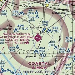
| Sectional chart |
|---|
|
| Airport distance calculator |
|---|
|
|
| Sunrise and sunset |
|---|
|
Times for 30-May-2026
| | Local
(UTC-4) | | Zulu
(UTC) |
|---|
| Morning civil twilight | | 05:57 | | 09:57 |
| Sunrise | | 06:25 | | 10:25 |
| Sunset | | 20:28 | | 00:28 |
| Evening civil twilight | | 20:55 | | 00:55 |
|
| Current date and time |
|---|
| Zulu (UTC) | 31-May-2026 00:47:10 |
|---|
| Local (UTC-4) | 30-May-2026 20:47:10 |
|---|
|
| METAR |
|---|
| KRVJ | 310035Z AUTO 24004KT 10SM CLR 26/23 A2989 RMK AO2 LTG DSNT E T02620227
|
KVDI
14nm NW | 310035Z AUTO 26003KT 10SM CLR 26/22 A2989 RMK AO2 LTG DSNT E
|
KCWV
17nm NE | 310035Z AUTO 03004KT 10SM VCTS CLR 27/24 A2988 RMK AO2 LTG DSNT SE AND SW
|
KMHP
19nm N | 310035Z AUTO 00000KT 10SM BKN036 27/23 A2989 RMK AO2 LTG DSNT SE T02650228
|
|
| TAF |
|---|
KSAV
49nm E | 302301Z 3023/3118 06010KT P6SM VCTS SCT040 BKN080CB TEMPO 3023/3024 VRB10G15KT 4SM TSRA BR BKN040CB FM310300 VRB03KT P6SM SCT025 BKN100 FM310800 06009KT P6SM VCSH BKN015 FM311500 08011G18KT 6SM -SHRA BR BKN015
|
|
| NOTAMs |
|---|
NOTAMs are issued by the DoD/FAA and will open in a separate window not controlled by AirNav.
|
|


