FAA INFORMATION EFFECTIVE 16 APRIL 2026
Location
| FAA Identifier: | RXE |
| Lat/Long: | 43-50-02.1000N 111-48-18.4000W
43-50.035000N 111-48.306667W
43.8339167,-111.8051111
(estimated) |
| Elevation: | 4862 ft. / 1481.9 m (surveyed) |
| Variation: | 15E (1990) |
| From city: | 1 mile NW of REXBURG, ID |
| Time zone: | UTC -6 (UTC -7 during Standard Time) |
| Zip code: | 83440 |
Airport Operations
| Airport use: | Open to the public |
| Activation date: | 07/1949 |
| Control tower: | no |
| ARTCC: | SALT LAKE CITY CENTER |
| FSS: | BOISE FLIGHT SERVICE STATION |
| NOTAMs facility: | RXE (NOTAM-D service available) |
| Attendance: | MON-SAT 0800-1800 |
| Wind indicator: | yes |
| Segmented circle: | yes |
| Lights: | ACTVT REIL RWY 35; VASI RWY 35; MIRL 17/35 - CTAF. VASI RWY 17 OPR CONSLY. |
| Beacon: | white-green (lighted land airport)
Operates sunset to sunrise. |
Airport Communications
| CTAF/UNICOM: | 122.8 |
| WX ASOS: | 135.075 (208-356-0986) |
- APCH/DEP CTL SVC PRVDD BY SALT LAKE ARTCC (ZLC) ON FREQS 128.35/239.25 (ASHTON RCAG).
Nearby radio navigation aids
| VOR radial/distance | | VOR name | | Freq | | Var |
|---|
| IDAr016/22.0 | | IDAHO FALLS VOR/DME | | 113.85 | | 15E |
| DBSr116/23.2 | | DUBOIS VORTAC | | 116.90 | | 15E |
Airport Services
| Fuel available: | 100LL JET-A |
| Parking: | tiedowns |
| Airframe service: | MAJOR |
| Powerplant service: | MAJOR |
| Bottled oxygen: | HIGH |
| Bulk oxygen: | NONE |
Runway Information
Runway 17/35
| Dimensions: | 4204 x 75 ft. / 1281 x 23 m |
| Surface: | asphalt, in good condition |
| Weight bearing capacity: | |
| Runway edge lights: | medium intensity |
| RUNWAY 17 | | RUNWAY 35 |
| Latitude: | 43-50.378610N | | 43-49.691222N |
| Longitude: | 111-48.252870W | | 111-48.360570W |
| Elevation: | 4858.1 ft. | | 4858.6 ft. |
| Traffic pattern: | left | | left |
| Runway heading: | 171 magnetic, 186 true | | 351 magnetic, 006 true |
| Displaced threshold: | 302 ft. | | no |
| Declared distances: | TORA:4200 TODA:4200 ASDA:4200 LDA:3900 | | TORA:4200 TODA:4200 ASDA:3900 LDA:3900 |
| Markings: | nonprecision, in good condition | | nonprecision, in good condition |
| Visual slope indicator: | 4-box VASI on right | | 4-box VASI on left (3.00 degrees glide path) |
| Runway end identifier lights: | | | yes |
| Touchdown point: | yes, no lights | | yes, no lights |
| Obstructions: | 35 ft. trees, 470 ft. from runway, 150 ft. left of centerline, 7:1 slope to clear
+20 TO 50 FT TREES AT 160 FT; 150 FT LEFT & RIGHT. | | 50 ft. tree, 725 ft. from runway, 150 ft. left of centerline, 10:1 slope to clear |
Airport Ownership and Management from official FAA records
| Ownership: | Publicly-owned |
| Owner: | CITY OF REXBURG & MADISON CO
P.O. BOX 280
REXBURG, ID 83440
Phone 208-359-3020 |
| Manager: | DAVID TAYLOR
PO BOX 70
REXBURG, ID 83440
Phone 208-356-9960 |
Additional Remarks
| - | FOR CD CTC SALT LAKE ARTCC AT 801-320-2568. |
| - | (CONTACT TITLE) EMAIL: KEITH.DAVIDSON@REXBURG.ORG |
Instrument Procedures
NOTE: All procedures below are presented as PDF files. If you need a reader for these files, you should download the free Adobe Reader.NOT FOR NAVIGATION. Please procure official charts for flight.
FAA instrument procedures published for use from 16 April 2026 at 0901Z to 14 May 2026 at 0900Z.
IAPs - Instrument Approach Procedures |
|---|
| RNAV (GPS) RWY 35 | |
download (205KB) |
| VOR RWY 35 | |
download (236KB) |
| NOTE: Special Alternate Minimums apply | |
download (211KB) |
| NOTE: Special Take-Off Minimums/Departure Procedures apply | |
download (461KB) |
Other nearby airports with instrument procedures:
KIDA - Idaho Falls Regional Airport (22 nm SW)
KDIJ - Driggs/Reed Memorial Airport (31 nm E)
U02 - McCarley Field Airport (44 nm SW)
KJAC - Jackson Hole Airport (48 nm E)
KWYS - Yellowstone Airport (59 nm NE)
|
|

Road maps at:
MapQuest
Bing
Google
| Aerial photo |
|---|
WARNING: Photo may not be current or correct
 Photo courtesy of GDA Engineers
Photo taken 08-Jul-2013
looking north.
Photo courtesy of GDA Engineers
Photo taken 08-Jul-2013
looking north.
Do you have a better or more recent aerial photo of Rexburg-Madison County Airport that you would like to share? If so, please send us your photo.
|
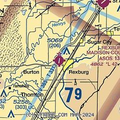
| Sectional chart |
|---|
|
| Airport distance calculator |
|---|
|
|
| Sunrise and sunset |
|---|
|
Times for 08-May-2026
| | Local
(UTC-6) | | Zulu
(UTC) |
|---|
| Morning civil twilight | | 05:38 | | 11:38 |
| Sunrise | | 06:11 | | 12:11 |
| Sunset | | 20:37 | | 02:37 |
| Evening civil twilight | | 21:09 | | 03:09 |
|
| Current date and time |
|---|
| Zulu (UTC) | 08-May-2026 16:01:57 |
|---|
| Local (UTC-6) | 08-May-2026 10:01:57 |
|---|
|
| METAR |
|---|
| KRXE | 081553Z AUTO 24004KT 10SM CLR 14/M01 A3004 RMK AO2 SLP143 T01391006
|
|
| TAF |
|---|
KIDA
22nm SW | 081120Z 0812/0912 VRB05KT P6SM SKC FM081800 22012G22KT P6SM FEW120 SCT200 FM090000 21018G28KT P6SM BKN120 FM090600 22010KT P6SM SKC
|
|
| NOTAMs |
|---|
NOTAMs are issued by the DoD/FAA and will open in a separate window not controlled by AirNav.
|
|

