FAA INFORMATION EFFECTIVE 09 JULY 2026
Location
| FAA Identifier: | SEM |
| Lat/Long: | 32-20-38.2080N 086-59-16.1000W
32-20.636800N 086-59.268333W
32.3439467,-86.9878056
(estimated) |
| Elevation: | 166.2 ft. / 50.7 m (surveyed) |
| Variation: | 03W (2015) |
| From city: | 4 miles SE of SELMA, AL |
| Time zone: | UTC -5 (UTC -6 during Standard Time) |
| Zip code: | 36701 |
Airport Operations
| Airport use: | Open to the public |
| Activation date: | 02/1979 |
| Control tower: | yes |
| ARTCC: | ATLANTA CENTER |
| FSS: | ANNISTON FLIGHT SERVICE STATION |
| NOTAMs facility: | ANB (NOTAM-D service available) |
| Attendance: | 0800-1800 |
| Wind indicator: | lighted |
| Segmented circle: | no |
| Lights: | WHEN ATCT CLSD ACTVT MALS RWY 33; PAPI RWY 15/33 AND HIRL RWY 15/33 - CTAF. |
| Beacon: | white-green (lighted land airport)
Operates sunset to sunrise. |
Airport Communications
| CTAF/UNICOM: | 122.7 |
| WX AWOS-3PT: | 119.15 ((334) 872-9090) |
| CRAIG GROUND: | 121.675 [0700-1900 MON-FRI; 0900-1700 SAT & SUN] |
| CRAIG TOWER: | 120.85 [0700-1900 MON-FRI; 0900-1700 SAT & SUN] |
| MONTGOMERY APPROACH: | 124.0 |
| MONTGOMERY DEPARTURE: | 124.0 |
- APCH/DEP SVC PRVDD BY ATLANTA ARTCC ON FREQS 120.55/270.25 (MONTGOMERY RCAG) WHEN MONTGOMERY APCH CTL CLSD.
Nearby radio navigation aids
| VOR radial/distance | | VOR name | | Freq | | Var |
|---|
| MGMr279/34.7 | | MONTGOMERY VORTAC | | 112.10 | | 03E |
| NDB name | | Hdg/Dist | | Freq | | Var | | ID |
|---|
| POLLK | | 329/5.4 | | 344 | | 03W | | SE | ... . |
Airport Services
| Fuel available: | 100LL JET-A
100LL:24HR 100LL AND JET A AVBL CALL 334-651-1511 AFT HRS. |
| Parking: | hangars and tiedowns |
| Airframe service: | MAJOR |
| Powerplant service: | MAJOR |
| Bulk oxygen: | NONE |
Runway Information
Runway 15/33
| Dimensions: | 8014 x 150 ft. / 2443 x 46 m |
| Surface: | asphalt/concrete, in poor condition
SEVERE CRACKING EXISTS ON ALL RUNWAY SURFACES. REHABILITATION PROJECT IS PLANNED. |
| Weight bearing capacity: | | Single wheel: | 33.0 | | Double wheel: | 54.0 |
|
| Runway edge lights: | high intensity |
| Runway edge markings: | RWY ID AND TD MRKGS SEVERELY FADED. |
| RUNWAY 15 | | RUNWAY 33 |
| Latitude: | 32-21.183108N | | 32-20.089938N |
| Longitude: | 086-59.705538W | | 086-58.830547W |
| Elevation: | 166.2 ft. | | 165.1 ft. |
| Traffic pattern: | left | | left |
| Runway heading: | 149 magnetic, 146 true | | 329 magnetic, 326 true |
| Markings: | precision, in poor condition | | precision, in poor condition |
| Visual slope indicator: | 4-light PAPI on left (3.00 degrees glide path) | | 4-light PAPI on left (3.00 degrees glide path) |
| Approach lights: | | | MALS: 1,400 foot medium intensity approach lighting system |
| Touchdown point: | yes, no lights | | yes, no lights |
| Instrument approach: | | | ILS/DME |
| Obstructions: | 41 ft. tree, 1249 ft. from runway, 384 ft. left of centerline, 25:1 slope to clear | | 43 ft. tree, 1620 ft. from runway, 336 ft. left of centerline, 33:1 slope to clear |
Airport Ownership and Management from official FAA records
| Ownership: | Publicly-owned |
| Owner: | CRAIG FLD ARPT & IND AUTH
PO BOX 1421
SELMA, AL 36702
Phone 334-874-7419
JAMES CORRIGAN, EXECUTIVE DIRECTOR |
| Manager: | DAN LANE
CRAIG FIELD INDUSTRIAL, HANGAR 202, AVENUE J
SELMA, AL 36701
Phone 334-419-3881
ALT 334-874-7419. |
Additional Remarks
| - | FOR CD IF UNA TO CTC ON FSS FREQ, CTC DANNELLY APCH AT 334-284-4575, WHEN ATCT CLSD CTC ATLANTA ARTCC AT 770-210-7692. |
Instrument Procedures
NOTE: All procedures below are presented as PDF files. If you need a reader for these files, you should download the free Adobe Reader.NOT FOR NAVIGATION. Please procure official charts for flight.
FAA instrument procedures published for use from 09 July 2026 at 0901Z to 06 August 2026 at 0900Z.
IAPs - Instrument Approach Procedures |
|---|
| ILS Y OR LOC Y RWY 33 | |
download (340KB) |
| ILS Z OR LOC Z RWY 33 | |
download (342KB) |
| RNAV (GPS) RWY 15 | |
download (257KB) |
| RNAV (GPS) RWY 33 | |
download (309KB) |
| NOTE: Special Alternate Minimums apply | |
download (158KB) |
| NOTE: Special Take-Off Minimums/Departure Procedures apply | |
download (490KB) |
Other nearby airports with instrument procedures:
A08 - Vaiden Field Airport (22 nm NW)
1A9 - Prattville Airport - Grouby Field (25 nm E)
61A - Camden Municipal Airport (28 nm SW)
KMGM - Montgomery Regional Airport (Dannelly Field) (30 nm E)
KMXF - Maxwell Air Force Base (32 nm E)
|
|

Road maps at:
MapQuest
Bing
Google
| Aerial photo |
|---|
WARNING: Photo may not be current or correct
 Photo courtesy of www.AceAerialPhoto.US Auburn Alabama
Photo taken 09-Jun-2006
Photo courtesy of www.AceAerialPhoto.US Auburn Alabama
Photo taken 09-Jun-2006
Do you have a better or more recent aerial photo of Craig Field Airport that you would like to share? If so, please send us your photo.
|
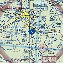
| Sectional chart |
|---|
|
| Airport distance calculator |
|---|
|
|
| Sunrise and sunset |
|---|
|
Times for 01-Aug-2026
| | Local
(UTC-5) | | Zulu
(UTC) |
|---|
| Morning civil twilight | | 05:37 | | 10:37 |
| Sunrise | | 06:04 | | 11:04 |
| Sunset | | 19:45 | | 00:45 |
| Evening civil twilight | | 20:12 | | 01:12 |
|
| Current date and time |
|---|
| Zulu (UTC) | 01-Aug-2026 11:02:37 |
|---|
| Local (UTC-5) | 01-Aug-2026 06:02:37 |
|---|
|
| METAR |
|---|
| KSEM | 011100Z AUTO 00000KT 8SM BKN050 OVC060 25/25 A2988 RMK AO2
|
|
| TAF |
|---|
KMGM
30nm E | 010750Z 0108/0206 21005KT P6SM BKN050 FM010900 20004KT P6SM OVC007 FM011800 24008KT P6SM OVC050 PROB30 0120/0124 VRB10G20KT 2SM TSRA BKN040CB FM020300 22004KT P6SM OVC050
|
KMXF
32nm E | 010230Z 0102/0201 25003KT 3200 +SHRA BKN020 OVC030 QNH2990INS TEMPO 0103/0109 22003KT 1200 +TSRA SCT016 BKN024CB OVC040 BECMG 0109/0110 23003KT 8000 -SHRA SCT015 BKN025 OVC040 QNH2986INS BECMG 0113/0114 18006KT 9999 NSW FEW040 BKN055 OVC080 QNH2975INS BECMG 0118/0119 VRB06KT 9000 -SHRA FEW030 BKN045 QNH2977INS TX35/0120Z TN25/0111Z LAST NO AMDS AFT 0103 NEXT 0111
|
|
| NOTAMs |
|---|
NOTAMs are issued by the DoD/FAA and will open in a separate window not controlled by AirNav.
|
|


