FAA INFORMATION EFFECTIVE 14 MAY 2026
Location
| FAA Identifier: | MGM |
| Lat/Long: | 32-18-02.3000N 086-23-38.3000W
32-18.038333N 086-23.638333W
32.3006389,-86.3939722
(estimated) |
| Elevation: | 232 ft. / 70.7 m (surveyed) |
| Variation: | 01W (1990) |
| From city: | 6 miles SW of MONTGOMERY, AL |
| Time zone: | UTC -5 (UTC -6 during Standard Time) |
| Zip code: | 36043 |
Airport Operations
| Airport use: | Open to the public |
| Activation date: | 06/1987 |
| Control tower: | yes |
| ARTCC: | ATLANTA CENTER |
| FSS: | ANNISTON FLIGHT SERVICE STATION |
| NOTAMs facility: | MGM (NOTAM-D service available) |
| Attendance: | CONTINUOUS |
| Pattern altitude: | 1432 ft. MSL
TPA: 1200 FT AGL CONV ACFT, 1700 FT AGL JET ACFT. |
| Wind indicator: | lighted |
| Segmented circle: | yes |
| Lights: | WHEN ATCT CLSD HIRL RWY 10/28 PRESET MED INTST, MIRL RWY 03/21 PRESET LOW INTST. PAPI RWYS 03, 21, 10, & 28 OPR CONSLY. ACTVT MALSR RWYS 10 & 28; REIL RWY 03 - CTAF. |
| Beacon: | white-green (lighted land airport)
Operates sunset to sunrise. |
| Fire and rescue: | ARFF index B |
| Airline operations: | CLSD TO UNSKED ACR OPNS & LRG MIL ACFT REQUIRING PARKING, EXCP WITH 72 HRS PPR CTC AMGR 334-281-5040. |
Airport Communications
| CTAF: | 119.7 |
| UNICOM: | 122.95 |
| ATIS: | 120.675 |
| WX ASOS: | PHONE 334-245-6083 |
| DANNELLY GROUND: | 121.7 348.6 [0600-2300] |
| DANNELLY TOWER: | 119.7 360.85 [0600-2300] |
| MONTGOMERY APPROACH: | 124.0 363.025 [0600-2300] |
| ATLANTA ARTCC APPROACH: | 112.1T 118.85 ;NORTH 132.45 ;SOUTH 255.6 ;NORTH 322.5 ;SOUTH [2300-0600.] |
| MONTGOMERY DEPARTURE: | 124.0 363.025 [0600-2300] |
| CLEARANCE DELIVERY: | 118.3 270.3 |
| ANG OPS: | 286.5 360.975 40.3FM |
| EMERG: | 121.5 243.0 |
| IC: | 124.0 363.025 |
| SFA: | 122.85 284.0 307.075 |
| TRSA: | 124.0 363.025 |
| WX AWOS-3P at 1A9 (10 nm NW): | 118.025 (334-358-0919) |
- APCH/DEP SVC PRVDD BY ATLANTA ARTCC ON FREQS 120.55/270.25 (MONTGOMERY RCAG) WHEN APCH CTL CLSD.
- SECTORIZATION BASED ON MONTGOMERY VORTAC.
- ARNG OPS 38.2 149.775 226.35 (PRIMARY).
Nearby radio navigation aids
| VOR radial/distance | | VOR name | | Freq | | Var |
|---|
| MGMr318/6.0 | | MONTGOMERY VORTAC | | 112.10 | | 03E |
| NDB name | | Hdg/Dist | | Freq | | Var | | ID |
|---|
| MARRA | | 097/6.0 | | 245 | | 01W | | MG | -- --. |
| BLOOD | | 337/31.8 | | 365 | | 04W | | TOI | - --- .. |
Airport Services
| Fuel available: | 100LL JET-A JET-A++
A:SERVICE-FUEL: ( A++100 (MIL)). |
| Parking: | hangars and tiedowns |
| Airframe service: | MAJOR |
| Powerplant service: | MAJOR |
| Bottled oxygen: | NONE |
| Bulk oxygen: | HIGH/LOW
UP TO 2200 PSI. |
Runway Information
Runway 10/28
| Dimensions: | 9020 x 150 ft. / 2749 x 46 m |
| Surface: | asphalt/grooved, in good condition |
| Weight bearing capacity: | | Single wheel: | 105.0 | | Double wheel: | 116.0 | | Double tandem: | 180.0 | | Dual double tandem: | DC-10-10 320; DC-10-30 & 40 400; L1011 350; B747 500. |
|
| Runway edge lights: | high intensity |
| Operational restrictions: | MILITARY: RWY 10 AND RWY 28 BAK-12B(B) AVBL WITH 30 MIN PN 1200-0500Z++. 8 PT TIE-DOWNS ON BAK-12B(B). RAISED CABLE ON ATIS BCST. |
| RUNWAY 10 | | RUNWAY 28 |
| Latitude: | 32-18.143937N | | 32-17.988243N |
| Longitude: | 086-24.599632W | | 086-22.857758W |
| Elevation: | 219.3 ft. | | 195.5 ft. |
| Traffic pattern: | right | | left |
| Runway heading: | 097 magnetic, 096 true | | 277 magnetic, 276 true |
| Markings: | precision, in good condition | | precision, in good condition |
| Visual slope indicator: | 4-light PAPI on right (3.00 degrees glide path) | | 4-light PAPI on left (3.00 degrees glide path) |
| RVR equipment: | touchdown | | rollout |
| Approach lights: | MALSR: 1,400 foot medium intensity approach lighting system with runway alignment indicator lights | | MALSR: 1,400 foot medium intensity approach lighting system with runway alignment indicator lights |
| Touchdown point: | yes, no lights | | yes, no lights |
| Instrument approach: | ILS | | ILS |
| Obstructions: | 35 ft. tree, 1990 ft. from runway, 630 ft. left of centerline, 34:1 slope to clear | | 65 ft. tree, 2800 ft. from runway, 600 ft. right of centerline, 40:1 slope to clear |
Runway 3/21
| Dimensions: | 4011 x 150 ft. / 1223 x 46 m |
| Surface: | asphalt, in fair condition |
| Weight bearing capacity: | | Single wheel: | 40.0 | | Double wheel: | 95.0 |
|
| Runway edge lights: | medium intensity |
| Operational restrictions: | RWY 03/21 NOT AVBL FOR PART 121/PART 380 OPS WITH SKED PAX CARRYING OPS MORE THAN 9 PAX SEATS AND NON-SKED PAX CARRYING OPS MORE THAN 30 PAX SEATS. |
| RUNWAY 3 | | RUNWAY 21 |
| Latitude: | 32-17.699500N | | 32-18.254440N |
| Longitude: | 086-23.648352W | | 086-23.224472W |
| Elevation: | 221.1 ft. | | 186.5 ft. |
| Traffic pattern: | left | | left |
| Runway heading: | 034 magnetic, 033 true | | 214 magnetic, 213 true |
| Markings: | nonprecision, in good condition | | nonprecision, in good condition |
| Visual slope indicator: | 4-light PAPI on left (3.00 degrees glide path) | | 4-light PAPI on left (3.00 degrees glide path) |
| Runway end identifier lights: | yes | | |
| Touchdown point: | yes, no lights | | yes, no lights |
| Obstructions: | 22 ft. fence, 700 ft. from runway, 22:1 slope to clear | | 54 ft. tree, 1300 ft. from runway, 300 ft. left of centerline, 20:1 slope to clear |
Helipad H1
| Dimensions: | 90 x 90 ft. / 27 x 27 m |
| Surface: | concrete, in fair condition |
| Latitude: | 32-17.287500N | | |
| Longitude: | 086-23.666500W | | |
| Traffic pattern: | left | | left |
Airport Ownership and Management from official FAA records
| Ownership: | Publicly-owned |
| Owner: | MONTGOMERY AIRPORT AUTHORITY
4445 SELMA HWY
MONTGOMERY, AL 36108
Phone 334-281-5040 |
| Manager: | LOYD JENKINS
4445 SELMA HWY
MONTGOMERY, AL 36108
Phone 334-281-5040 |
Additional Remarks
| A39-03/21 | PCR VALUE: 150/F/A/X/T |
| A39-10/28 | PCR VALUE: 600/F/A/X/T |
| E60-28 | HOOK BAK-12B(B) (1510 FT). |
| E60-10 | HOOK BAK-12B(B) (1500 FT). |
| E115 | ALABAMA ANG ONLY. |
| - | NO 180 DEG TURNS ON RWY 10/28 BY DC-9 OR LARGER ACFT. |
| - | ACR & LRG MIL ACFT SHOULD NOT TAXI ON RWY 03/21. |
| - | MILITARY: BIRD HAZARD. CTC BASE OPS ON 360.975 FOR CURRENT BIRD WATCH COND. BASH PHASE II BIRD ACT IS DURG APR AND FM 1 SEP TO 31 DEC. |
| - | ARNG - F/W ACFT INBD TO ARNG RAMP CTC ARNG 10MIN PRIOR TO ETA AND UPON ENTY TWY D. L-3 (C-12)MAINT AVBL ON CALL, C334-280-4890 COMMUNICATIONS. |
| - | MILITARY: ANG: ONGOING CONSTR ON RAMP. CTC BASE OPS FOR TAX/PRKG INSTRNS DSN 358-9255 OR C334-394-7255. |
| - | ANG: RWY CC NOT RPT. |
| - | FOR CD IF UNA TO CTC ON FSS FREQ, CTC DANNELLY APCH AT 334-284-4575, WHEN ATCT CLSD CTC ATLANTA ARTCC AT 770-210-7692. |
| - | MILITARY: FLUID: LHNIT. |
| - | MILITARY: OIL: JOAP. |
| - | ANG RAMP - REDUCED WINGTIP CLEARANCE FOR PARKING SPOTS 11-16 WHEN F-35 LIGHTNING PROTECTION SYSTEMS IN USE. |
| - | RSTD - TWY E 35' WIDE, MIL ACFT RSTD FM USE. |
| - | CAUTION: DO NOT MISTAKE MAXWELL AFB - 6 NM NORTH FOR MONGOMERY RGNL. NUMEROUS HEL AND LOW SPEED ACFT INVOF ARPT DURG DALGT HRS. |
| - | ARNG: ANG RAMP CONST WIP. CTC AFLD MGMT FOR TAXI INSTR. TRANSPORT ACFT LTD TO MIN THRUST WHILE ON ANG RAMP. CONES BLOCKING THROAT OF ANG RAMP. CTC BASE OPS PRIOR TO ENTERING ANG RAMP FOR REMOVAL. INBD FOR ANG CTC BAMA OPS 15 MIN PRIOR LDG. ACFT PARKING EXTREMELY LMTD CTC BASE OPNS FOR PARKING INSTR. TSNT PARKING EXTREMELY LIMITED. PPR FOR USE OF ANG RAMP CTC ANG OPNS DSN358-9255/9256/C334-394-7255/7256. ANG BASE OPS FACILITY AVBL 1200-2230Z++. |
Instrument Procedures
NOTE: All procedures below are presented as PDF files. If you need a reader for these files, you should download the free Adobe Reader.NOT FOR NAVIGATION. Please procure official charts for flight.
FAA instrument procedures published for use from 14 May 2026 at 0901Z to 11 June 2026 at 0900Z.
IAPs - Instrument Approach Procedures |
|---|
| HI-ILS Y OR LOC Y RWY 10 | |
download (190KB) |
| ILS Y OR LOC RWY 28 | |
download (334KB) |
| ILS Z OR LOC Z RWY 10 | |
download (312KB) |
| ILS Z RWY 28 | |
download (204KB) |
| RNAV (GPS) RWY 03 | |
download (217KB) |
| RNAV (GPS) RWY 10 | |
download (256KB) |
| RNAV (GPS) RWY 28 | |
download (251KB) |
| VOR-A | |
download (186KB) |
| HI-TACAN-J | |
download (168KB) |
| NDB RWY 10 | |
download (211KB) |
| NOTE: Special Alternate Minimums apply | |
download (159KB) |
| NOTE: Special Take-Off Minimums/Departure Procedures apply | |
download (479KB) |
Other nearby airports with instrument procedures:
KMXF - Maxwell Air Force Base (5 nm N)
1A9 - Prattville Airport - Grouby Field (10 nm NW)
08A - Wetumpka Municipal Airport (14 nm N)
KPRN - Mac Crenshaw Memorial Airport (29 nm S)
KSEM - Craig Field Airport (30 nm W)
|
|

Road maps at:
MapQuest
Bing
Google
| Aerial photo |
|---|
WARNING: Photo may not be current or correct
 Photo by Don Neuberg, Outwardbound Photography
Photo taken 13-Jan-2012
looking southeast.
Photo by Don Neuberg, Outwardbound Photography
Photo taken 13-Jan-2012
looking southeast.
Do you have a better or more recent aerial photo of Montgomery Regional Airport (Dannelly Field) that you would like to share? If so, please send us your photo.
|
| Sectional chart |
|---|
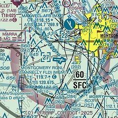
|
CAUTION: Diagram may not be current
 Download PDF
of official airport diagram from the FAA
| Airport distance calculator |
|---|
|
|
| Sunrise and sunset |
|---|
|
Times for 18-May-2026
| | Local
(UTC-5) | | Zulu
(UTC) |
|---|
| Morning civil twilight | | 05:19 | | 10:19 |
| Sunrise | | 05:47 | | 10:47 |
| Sunset | | 19:37 | | 00:37 |
| Evening civil twilight | | 20:05 | | 01:05 |
|
| Current date and time |
|---|
| Zulu (UTC) | 18-May-2026 13:05:13 |
|---|
| Local (UTC-5) | 18-May-2026 08:05:13 |
|---|
|
| METAR |
|---|
| KMGM | 181253Z 12005KT 10SM CLR 23/18 A3018 RMK AO2 SLP218 T02280183
|
KMXF
4nm N | 181155Z AUTO 06004KT 10SM SCT048 22/18 A3015 RMK AO2 SLP211 T02160178 10234 20195 52023 $
|
K1A9
10nm NW | 181255Z AUTO 08003KT 10SM CLR 22/18 A3019 RMK AO2 T02190178
|
|
| TAF |
|---|
| KMGM | 181133Z 1812/1912 09006KT P6SM FEW250 FM181500 14009KT P6SM SCT240 FM190000 VRB03KT P6SM SCT250
|
KMXF
4nm N | 181100Z 1811/1917 12003KT 8000 BR BKN005 OVC020 QNH3013INS BECMG 1815/1816 15006KT 9999 NSW FEW015 SCT025 BKN040 QNH3016INS BECMG 1906/1907 VRB03KT 8000 BR BKN002 QNH3012INS BECMG 1913/1914 14004KT 9999 NSW FEW005 SCT015 QNH3019INS TX31/1820Z TN15/1811Z
|
|
| NOTAMs |
|---|
NOTAMs are issued by the DoD/FAA and will open in a separate window not controlled by AirNav.
|
|


