FAA INFORMATION EFFECTIVE 19 MARCH 2026
Location
| FAA Identifier: | 08A |
| Lat/Long: | 32-31-38.4000N 086-19-51.7000W
32-31.640000N 086-19.861667W
32.5273333,-86.3310278
(estimated) |
| Elevation: | 197.1 ft. / 60.1 m (surveyed) |
| Variation: | 03W (2010) |
| From city: | 6 miles W of WETUMPKA, AL |
| Time zone: | UTC -5 (UTC -6 during Standard Time) |
| Zip code: | 36025 |
Airport Operations
| Airport use: | Open to the public |
| Control tower: | no |
| ARTCC: | ATLANTA CENTER |
| FSS: | ANNISTON FLIGHT SERVICE STATION |
| NOTAMs facility: | ANB (NOTAM-D service available) |
| Attendance: | MON-FRI 0800-1700
FOR ARPT ATTENDANT AFT HRS CALL 334-233-7320 |
| Wind indicator: | lighted |
| Segmented circle: | yes |
| Lights: | DUSK-DAWN. ACTVT MIRL RWY 09/27 - CTAF. |
| Beacon: | white-green (lighted land airport)
Operates sunset to sunrise. |
Airport Communications
| CTAF/UNICOM: | 123.05 |
| MONTGOMERY APPROACH: | 121.2 |
| MONTGOMERY DEPARTURE: | 121.2 |
| WX AWOS-3P at 1A9 (11 nm SW): | 118.025 (334-358-0919) |
| WX ASOS at MGM (14 nm S): | PHONE 334-245-6083 |
- APCH/DEP SVC PRVDD BY ATLANTA ARTCC ON FREQS 120.45/298.850 (COLUMBUS RCAG) WHEN MONTGOMERY APCH CTL CLSD.
Nearby radio navigation aids
| VOR radial/distance | | VOR name | | Freq | | Var |
|---|
| MGMr355/18.3 | | MONTGOMERY VORTAC | | 112.10 | | 03E |
Airport Services
| Fuel available: | 100LL |
| Parking: | tiedowns |
| Airframe service: | MAJOR |
| Powerplant service: | MAJOR |
| Bottled oxygen: | NONE |
| Bulk oxygen: | NONE |
Runway Information
Runway 9/27
| Dimensions: | 3013 x 80 ft. / 918 x 24 m |
| Surface: | asphalt, in poor condition
RWY CRACKING |
| Weight bearing capacity: | |
| Runway edge lights: | medium intensity |
| RUNWAY 9 | | RUNWAY 27 |
| Latitude: | 32-31.762908N | | 32-31.769813N |
| Longitude: | 086-19.986272W | | 086-19.399727W |
| Elevation: | 196.7 ft. | | 196.4 ft. |
| Traffic pattern: | left | | left |
| Runway heading: | 092 magnetic, 089 true | | 272 magnetic, 269 true |
| Markings: | nonprecision, in fair condition | | nonprecision, in fair condition |
| Runway end identifier lights: | yes | | yes |
| Touchdown point: | yes, no lights | | yes, no lights |
Runway 18/36
| Dimensions: | 2876 x 130 ft. / 877 x 40 m |
| Surface: | turf, in fair condition |
| Runway edge markings: | MKD WITH 36 INCH WHITE CONES. |
| RUNWAY 18 | | RUNWAY 36 |
| Latitude: | 32-31.744490N | | 32-31.270265N |
| Longitude: | 086-20.032017W | | 086-20.041198W |
| Elevation: | 195.7 ft. | | 191.0 ft. |
| Traffic pattern: | left | | left |
| Runway heading: | 184 magnetic, 181 true | | 004 magnetic, 001 true |
| Displaced threshold: | no | | 983 ft. |
| Markings: | basic, in good condition | | basic, in good condition |
| Touchdown point: | yes, no lights | | yes, no lights |
| Obstructions: | 108 ft. trees, marked, 1547 ft. from runway, 84 ft. left of centerline, 14:1 slope to clear | | 111 ft. trees, 1588 ft. from runway, 32 ft. left of centerline, 14:1 slope to clear
RWY 36 APCH RATIO 15:1 FM DSPLCD THR. |
Airport Ownership and Management from official FAA records
| Ownership: | Publicly-owned |
| Owner: | CITY OF WETUMPKA
PO BOX 1180
WETUMPKA, AL 36092
Phone 334-567-5147 |
| Manager: | LYNN WELDON
1285 HIGHWAY 14
ELMORE, AL 36025
Phone 334-285-5843 |
Additional Remarks
| - | FOR CD CTC MONTGOMERY APCH AT 334-284-4575. WHEN APCH CLSD FOR CD CTC ATLANTA ARTCC AT 770-210-7692. |
Instrument Procedures
NOTE: All procedures below are presented as PDF files. If you need a reader for these files, you should download the free Adobe Reader.NOT FOR NAVIGATION. Please procure official charts for flight.
FAA instrument procedures published for use from 19 March 2026 at 0901Z to 16 April 2026 at 0900Z.
IAPs - Instrument Approach Procedures |
|---|
| RNAV (GPS) RWY 09 | |
download (221KB) |
| RNAV (GPS) RWY 27 | |
download (219KB) |
| NOTE: Special Take-Off Minimums/Departure Procedures apply | |
download (189KB) |
Other nearby airports with instrument procedures:
KMXF - Maxwell Air Force Base (9 nm S)
1A9 - Prattville Airport - Grouby Field (11 nm SW)
KMGM - Montgomery Regional Airport (Dannelly Field) (14 nm S)
02A - Chilton County Airport (24 nm NW)
KALX - Thomas C Russell Field Airport (30 nm NE)
|
|

Road maps at:
MapQuest
Bing
Google
| Aerial photo |
|---|
WARNING: Photo may not be current or correct
 Photo by Tom Prevost
Photo taken 24-Nov-2017
looking north.
Photo by Tom Prevost
Photo taken 24-Nov-2017
looking north.
Do you have a better or more recent aerial photo of Wetumpka Municipal Airport that you would like to share? If so, please send us your photo.
|
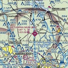
| Sectional chart |
|---|
|
| Airport distance calculator |
|---|
|
|
| Sunrise and sunset |
|---|
|
Times for 21-Mar-2026
| | Local
(UTC-5) | | Zulu
(UTC) |
|---|
| Morning civil twilight | | 06:24 | | 11:24 |
| Sunrise | | 06:49 | | 11:49 |
| Sunset | | 18:56 | | 23:56 |
| Evening civil twilight | | 19:21 | | 00:21 |
|
| Current date and time |
|---|
| Zulu (UTC) | 22-Mar-2026 02:21:23 |
|---|
| Local (UTC-5) | 21-Mar-2026 21:21:23 |
|---|
|
| METAR |
|---|
KMXF
10nm S | 220155Z AUTO 00000KT 10SM CLR 19/11 A2995 RMK AO2 SLP144 T01930111
|
K1A9
11nm SW | 220155Z AUTO 00000KT 10SM CLR 18/12 A2998 RMK AO2 T01800124
|
KMGM
14nm S | 220153Z 20004KT 10SM CLR 21/09 A2998 RMK AO2 SLP151 T02110094
|
|
| TAF |
|---|
KMXF
10nm S | 211900Z 2119/2301 22006KT 9999 FEW250 QNH3000INS TEMPO 2212/2214 8000 BR BKN012 BKN250 BECMG 2214/2215 23009KT 9999 SKC QNH3005INS TX27/2121Z TN14/2212Z LAST NO AMDS AFT 2123 NEXT 2211
|
KMGM
14nm S | 211720Z 2118/2218 25007KT P6SM SCT250 FM220100 21003KT P6SM SKC FM221600 23007KT P6SM SKC
|
|
| NOTAMs |
|---|
NOTAMs are issued by the DoD/FAA and will open in a separate window not controlled by AirNav.
|
|

