FAA INFORMATION EFFECTIVE 25 DECEMBER 2025
Location
| FAA Identifier: | STK |
| Lat/Long: | 40-36-51.4730N 103-15-51.3400W
40-36.857883N 103-15.855667W
40.6142981,-103.2642611
(estimated) |
| Elevation: | 4037.6 ft. / 1230.7 m (surveyed) |
| Variation: | 08E (2015) |
| From city: | 3 miles W of STERLING, CO |
| Time zone: | UTC -7 (UTC -6 during Daylight Saving Time) |
| Zip code: | 80751 |
Airport Operations
| Airport use: | Open to the public |
| Activation date: | 04/1940 |
| Control tower: | no |
| ARTCC: | DENVER CENTER |
| FSS: | DENVER FLIGHT SERVICE STATION |
| NOTAMs facility: | DEN (NOTAM-D service available) |
| Attendance: | 0700-1600
FOR AFT HRS SVC CALL 970-520-2325. |
| Wind indicator: | lighted |
| Segmented circle: | yes |
| Lights: | WHEN ATCT CLSD ACTVT REIL RWY 15 & 33; MIRL RWY 15/33 - CTAF. PAPI RWY 15 & 33 OPR CONSLY. INCR MIRL INTST - CTAF. |
| Beacon: | white-green (lighted land airport)
Operates sunset to sunrise. |
Airport Communications
| CTAF/UNICOM: | 122.8 |
| WX AWOS-3: | 118.525 (970-526-3009) |
- APCH/DEP CTL SVC PRVDD BY DENVER (ZDV) ON FREQS 118.475/225.4 (BRUSH/B/ RCAG).
Nearby radio navigation aids
| VOR radial/distance | | VOR name | | Freq | | Var |
|---|
| AKOr339/27.8 | | AKRON VOR/DME | | 114.40 | | 13E |
| SNYr191/31.6 | | SIDNEY VOR/DME | | 115.90 | | 13E |
Airport Services
| Fuel available: | 100LL JET-A |
| Parking: | hangars and tiedowns |
Runway Information
Runway 15/33
| Dimensions: | 5201 x 75 ft. / 1585 x 23 m |
| Surface: | asphalt, in good condition |
| Weight bearing capacity: | |
| Runway edge lights: | medium intensity |
| RUNWAY 15 | | RUNWAY 33 |
| Latitude: | 40-37.306785N | | 40-36.488970N |
| Longitude: | 103-16.023782W | | 103-15.690477W |
| Elevation: | 4037.5 ft. | | 4025.6 ft. |
| Traffic pattern: | left | | left |
| Runway heading: | 155 magnetic, 163 true | | 335 magnetic, 343 true |
| Markings: | nonprecision, in good condition | | precision, in good condition |
| Visual slope indicator: | 2-light PAPI on left (3.00 degrees glide path) | | 2-light PAPI on left (3.00 degrees glide path) |
| Runway end identifier lights: | yes | | yes |
| Touchdown point: | yes, no lights | | yes, no lights |
| Obstructions: | 31 ft. tree, 608 ft. from runway, 266 ft. right of centerline, 13:1 slope to clear | | none |
Runway 4/22
| Dimensions: | 2809 x 150 ft. / 856 x 46 m |
| Surface: | turf/gravel, in fair condition
VARMINT HOLES NEAR RWY 04 END. |
| RUNWAY 4 | | RUNWAY 22 |
| Latitude: | 40-36.621425N | | 40-36.946255N |
| Longitude: | 103-16.069073W | | 103-15.636900W |
| Elevation: | 4032.2 ft. | | 4028.7 ft. |
| Traffic pattern: | left | | left |
| Runway heading: | 037 magnetic, 045 true | | 217 magnetic, 225 true |
| Markings: | , in fair condition | | , in fair condition |
| Touchdown point: | yes, no lights | | yes, no lights |
| Obstructions: | 16 ft. road, 139 ft. from runway, 7 ft. left of centerline, 8:1 slope to clear | | 48 ft. tree, 614 ft. from runway, 34 ft. right of centerline, 12:1 slope to clear |
Airport Ownership and Management from official FAA records
| Ownership: | Publicly-owned |
| Owner: | CITY OF STERLING
P. O. BOX 4000
STERLING, CO 80751
Phone 970-522-9700 |
| Manager: | CHARLIE MAY
16562 HWY 14
STERLING, CO 80751
Phone 970-522-0417 |
Additional Remarks
| A30A-04 | MKG TYPE - COND: RWY 04/22 ENDS MKD WITH RED/GREEN REFLECTORS. |
| - | FOR CD CTC DENVER ARTCC AT 303-651-4257. |
| - | RWY 04 DEP HAS 8 FT FENCE 155 FT FM DEP END OF RWY. |
| - | TWY & TRML TIEDOWN AREA MKD WITH BLUE REFLECTORS. |
| - | AEROBATIC OPS ON AND INVOF ARPT. |
| - | BE ALERT; INTENSIVE USAF STUDENT TRG INVOF KCOS & KPUB ARPRTS. |
| - | INTENSIVE AG OPS MAR-SEPT. |
| - | RWY 4/22 SOFT AND ROUGH WHEN WET. |
Instrument Procedures
NOTE: All procedures below are presented as PDF files. If you need a reader for these files, you should download the free Adobe Reader.NOT FOR NAVIGATION. Please procure official charts for flight.
FAA instrument procedures published for use from 25 December 2025 at 0901z to 22 January 2026 at 0900z.
IAPs - Instrument Approach Procedures |
|---|
| RNAV (GPS) RWY 15 | |
download (226KB) |
| RNAV (GPS) RWY 33 | |
download (210KB) |
| NOTE: Special Alternate Minimums apply | |
download (156KB) |
| NOTE: Special Take-Off Minimums/Departure Procedures apply | |
download (105KB) |
Other nearby airports with instrument procedures:
KAKO - Colorado Plains Regional Airport (26 nm S)
KFMM - Fort Morgan Municipal Airport (30 nm SW)
KSNY - Sidney Municipal Airport/Lloyd W. Carr Field (32 nm NE)
KIBM - Kimball Municipal Airport/Robert E Arraj Field (39 nm NW)
2V6 - Yuma Municipal Airport (40 nm SE)
|
|

Road maps at:
MapQuest
Bing
Google
| Aerial photo |
|---|
WARNING: Photo may not be current or correct
 Photo taken 01-Dec-2010
looking north.
Photo taken 01-Dec-2010
looking north.
Do you have a better or more recent aerial photo of Sterling Municipal Airport that you would like to share? If so, please send us your photo.
|
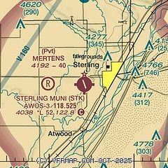
| Sectional chart |
|---|
|
| Airport distance calculator |
|---|
|
|
| Sunrise and sunset |
|---|
|
Times for 19-Jan-2026
| | Local
(UTC-7) | | Zulu
(UTC) |
|---|
| Morning civil twilight | | 06:44 | | 13:44 |
| Sunrise | | 07:14 | | 14:14 |
| Sunset | | 16:54 | | 23:54 |
| Evening civil twilight | | 17:24 | | 00:24 |
|
| Current date and time |
|---|
| Zulu (UTC) | 20-Jan-2026 03:24:59 |
|---|
| Local (UTC-7) | 19-Jan-2026 20:24:59 |
|---|
|
| METAR |
|---|
| KSTK | 200255Z AUTO 00000KT 10SM CLR M06/M08 A3013 RMK AO2
|
|
| TAF |
|---|
KSNY
32nm NE | 191720Z 1918/2018 28011KT P6SM SCT050 FM191900 31015G23KT P6SM SKC FM200000 27008KT P6SM FEW150 FM201700 26014G22KT P6SM BKN250
|
|
| NOTAMs |
|---|
NOTAMs are issued by the DoD/FAA and will open in a separate window not controlled by AirNav.
|
|


