FAA INFORMATION EFFECTIVE 14 MAY 2026
Location
| FAA Identifier: | SZY |
| Lat/Long: | 35-12-10.6000N 088-29-54.1000W
35-12.176667N 088-29.901667W
35.2029444,-88.4983611
(estimated) |
| Elevation: | 610.2 ft. / 186.0 m (surveyed) |
| Variation: | 01E (1990) |
| From city: | 5 miles NE of SELMER, TN |
| Time zone: | UTC -5 (UTC -6 during Standard Time) |
| Zip code: | 38375 |
Airport Operations
| Airport use: | Open to the public |
| Control tower: | no |
| ARTCC: | MEMPHIS CENTER |
| FSS: | JACKSON FLIGHT SERVICE STATION |
| NOTAMs facility: | MKL (NOTAM-D service available) |
| Attendance: | SUN 1000-1500, ALL MON-FRI 0800-1700, ALL SAT 0900-1600
AFT HR - 731-645-3014. CLSD 1600 M-F OCT - MAR. |
| Wind indicator: | lighted |
| Segmented circle: | no |
| Lights: | ACTVT MIRL RWY 17/35 - CTAF. |
| Beacon: | white-green (lighted land airport)
Operates sunset to sunrise. |
Airport Communications
| CTAF/UNICOM: | 122.7 |
| WX AWOS-3: | 118.425 (731-645-8184) |
| WX AWOS-3 at SNH (14 nm E): | 133.925 (731-925-6080) |
| WX AWOS-3PT at CRX (18 nm S): | 118.675 (662-287-5103) |
- APCH/DEP SVC PRVDD BY MEMPHIS ARTCC (ZME) ON FREQS 124.35/318.1 (MCKELLAR RCAG).
Nearby radio navigation aids
| VOR radial/distance | | VOR name | | Freq | | Var |
|---|
| MKLr141/31.4 | | MC KELLAR VOR/DME | | 114.85 | | 01W |
| NDB name | | Hdg/Dist | | Freq | | Var | | ID |
|---|
| SEYER | | 029/12.6 | | 334 | | 02W | | UU | ..- ..- |
Airport Services
| Fuel available: | 100LL JET-A+ |
| Parking: | hangars and tiedowns |
| Airframe service: | MAJOR |
| Powerplant service: | MAJOR |
Runway Information
Runway 17/35
| Dimensions: | 5002 x 75 ft. / 1525 x 23 m |
| Surface: | asphalt, in excellent condition |
| Weight bearing capacity: | | PCN 11 /F/D/X/T | | Single wheel: | 29.5 | | Double wheel: | 40.0 |
|
| Runway edge lights: | medium intensity |
| RUNWAY 17 | | RUNWAY 35 |
| Latitude: | 35-12.576328N | | 35-11.777655N |
| Longitude: | 088-30.026573W | | 088-29.776608W |
| Elevation: | 602.4 ft. | | 609.8 ft. |
| Traffic pattern: | left | | left |
| Runway heading: | 165 magnetic, 166 true | | 345 magnetic, 346 true |
| Markings: | nonprecision, in good condition | | nonprecision, in good condition |
| Visual slope indicator: | 2-light PAPI on left (3.00 degrees glide path) | | 2-light PAPI on left (4.00 degrees glide path) |
| Runway end identifier lights: | yes | | yes |
| Touchdown point: | yes, no lights | | yes, no lights |
| Obstructions: | 28 ft. tree, 357 ft. from runway, 71 ft. right of centerline, 5:1 slope to clear | | 30 ft. tree, 622 ft. from runway, 70 ft. left of centerline, 14:1 slope to clear |
Airport Ownership and Management from official FAA records
| Ownership: | Publicly-owned |
| Owner: | MC NAIRY COUNTY
CTY COURTHOUSE; COURT AVE
SELMER, TN 38375
Phone 731-645-3472 |
| Manager: | CHRIS TULL
2282 AIRPORT ROAD
SELMER, TN 38375
Phone 731-645-3014 |
Additional Remarks
| - | FOR CD CTC MEMPHIS ARTCC AT 901-368-8453/8449. |
Instrument Procedures
NOTE: All procedures below are presented as PDF files. If you need a reader for these files, you should download the free Adobe Reader.NOT FOR NAVIGATION. Please procure official charts for flight.
FAA instrument procedures published for use from 14 May 2026 at 0901Z to 11 June 2026 at 0900Z.
IAPs - Instrument Approach Procedures |
|---|
| RNAV (GPS) RWY 17 | |
download (251KB) |
| RNAV (GPS) RWY 35 | |
download (261KB) |
| NOTE: Special Take-Off Minimums/Departure Procedures apply | |
download (126KB) |
Other nearby airports with instrument procedures:
KSNH - Savannah-Hardin County Airport (14 nm E)
KCRX - Roscoe Turner Airport (18 nm S)
M08 - William L Whitehurst Field Airport (27 nm W)
15M - Segars Field Airport (31 nm SE)
KPVE - Beech River Regional Airport (31 nm NE)
|
|

Road maps at:
MapQuest
Bing
Google
| Aerial photo |
|---|
WARNING: Photo may not be current or correct
 Photo taken 07-Feb-2005
looking northwest
Photo taken 07-Feb-2005
looking northwest
Do you have a better or more recent aerial photo of Robert Sibley Airport that you would like to share? If so, please send us your photo.
|
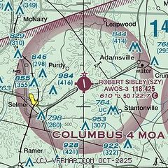
| Sectional chart |
|---|
|
| Airport distance calculator |
|---|
|
|
| Sunrise and sunset |
|---|
|
Times for 31-May-2026
| | Local
(UTC-5) | | Zulu
(UTC) |
|---|
| Morning civil twilight | | 05:13 | | 10:13 |
| Sunrise | | 05:42 | | 10:42 |
| Sunset | | 20:01 | | 01:01 |
| Evening civil twilight | | 20:31 | | 01:31 |
|
| Current date and time |
|---|
| Zulu (UTC) | 31-May-2026 17:12:42 |
|---|
| Local (UTC-5) | 31-May-2026 12:12:42 |
|---|
|
| METAR |
|---|
| KSZY | 311635Z AUTO VRB04KT 10SM BKN027 BKN036 29/22 A2998 RMK A01
|
KSNH
14nm E | 311650Z AUTO 00000KT 10SM BKN029 BKN037 BKN043 29/28 A2996 RMK A01
|
KCRX
18nm S | 311655Z AUTO 00000KT 10SM CLR 30/23 A2997 RMK AO2
|
|
| TAF |
|---|
KMKL
31nm NW | 311507Z 3115/0112 VRB03KT P6SM FEW010 BKN200 FM311700 28004KT P6SM SCT025 BKN035 FM311900 31005KT P6SM BKN045 FM010100 00000KT P6SM SCT050 BKN200 FM010900 00000KT 3SM BR SCT005
|
|
| NOTAMs |
|---|
NOTAMs are issued by the DoD/FAA and will open in a separate window not controlled by AirNav.
|
|

