FAA INFORMATION EFFECTIVE 22 JANUARY 2026
Location
| FAA Identifier: | TCY |
| Lat/Long: | 37-41-20.0230N 121-26-29.6690W
37-41.333717N 121-26.494483W
37.6888953,-121.4415747
(estimated) |
| Elevation: | 193.6 ft. / 59.0 m (surveyed) |
| Variation: | 15E (2000) |
| From city: | 3 miles SW of TRACY, CA |
| Time zone: | UTC -8 (UTC -7 during Daylight Saving Time) |
| Zip code: | 95376 |
Airport Operations
| Airport use: | Open to the public |
| Activation date: | 04/1940 |
| Control tower: | no |
| ARTCC: | OAKLAND CENTER |
| FSS: | RANCHO MURIETA FLIGHT SERVICE STATION |
| NOTAMs facility: | TCY (NOTAM-D service available) |
| Attendance: | 0800-1800 |
| Pattern altitude: | 993.6 ft. MSL |
| Wind indicator: | lighted |
| Segmented circle: | yes |
| Lights: | ACTVT REIL RWY 08, 26, 12, & 30; PAPI RWY 08, 12 & 26; MIRL RWY 08/26 & 12/30 - CTAF. PAPI RWY 30 IS OPRD AT NGT BY CTAF FROM SS TO SR AND IS ON DRG DALGT HRS. |
| Beacon: | white-green (lighted land airport)
Operates sunset to sunrise. |
Airport Communications
| CTAF/UNICOM: | 123.075 |
| WX AWOS-3: | 118.375 (209-831-4335) |
| NORCAL APPROACH: | 123.85 |
| NORCAL DEPARTURE: | 123.85 |
| WX AWOS-3 at C83 (12 nm NW): | 123.775 (925-634-0906) |
| WX ASOS at SCK (16 nm NE): | PHONE 209-625-0001 |
| WX ASOS at LVK (18 nm W): | PHONE 925-606-5412 |
Nearby radio navigation aids
| VOR radial/distance | | VOR name | | Freq | | Var |
|---|
| MODr262/23.3 | | MODESTO VOR/DME | | 114.60 | | 17E |
| SJCr036/30.5 | | SAN JOSE VOR/DME | | 114.10 | | 16E |
| LINr205/31.1 | | LINDEN VOR/DME | | 114.80 | | 17E |
| CCRr110/35.7 | | CONCORD VOR/DME | | 117.00 | | 17E |
| OAKr076/37.2 | | OAKLAND VOR/DME | | 116.80 | | 17E |
Airport Services
| Fuel available: | 100LL JET-A |
| Parking: | tiedowns |
| Airframe service: | MAJOR |
| Powerplant service: | MAJOR |
| Bottled oxygen: | LOW |
| Bulk oxygen: | NONE |
Runway Information
Runway 12/30
| Dimensions: | 4001 x 75 ft. / 1220 x 23 m |
| Surface: | asphalt, in good condition |
| Weight bearing capacity: | | Single wheel: | 50.0 | | Double wheel: | 70.0 | | Double tandem: | 120.0 |
|
| Runway edge lights: | medium intensity |
| RUNWAY 12 | | RUNWAY 30 |
| Latitude: | 37-41.468605N | | 37-41.031510N |
| Longitude: | 121-26.765603W | | 121-26.144645W |
| Elevation: | 180.9 ft. | | 193.6 ft. |
| Traffic pattern: | left | | left |
| Runway heading: | 117 magnetic, 132 true | | 297 magnetic, 312 true |
| Displaced threshold: | no | | 261 ft. |
| Markings: | nonprecision, in good condition | | nonprecision, in good condition |
| Visual slope indicator: | 2-light PAPI on left (3.00 degrees glide path)
UNUSBL BYD 5 DEGS LEFT OF CNTRLN. | | 2-light PAPI on left (3.00 degrees glide path) |
| Runway end identifier lights: | yes | | yes |
| Touchdown point: | yes, no lights | | yes, no lights |
| Obstructions: | 25 ft. bldg, 1100 ft. from runway, 36:1 slope to clear | | 15 ft. road, 510 ft. from runway, 280 ft. right of centerline, 20:1 slope to clear |
Runway 8/26
| Dimensions: | 3438 x 75 ft. / 1048 x 23 m |
| Surface: | asphalt, in good condition |
| Weight bearing capacity: | | Single wheel: | 50.0 | | Double wheel: | 70.0 | | Double tandem: | 120.0 |
|
| Runway edge lights: | medium intensity |
| RUNWAY 8 | | RUNWAY 26 |
| Latitude: | 37-41.429080N | | 37-41.433073N |
| Longitude: | 121-26.896690W | | 121-26.183950W |
| Elevation: | 190.3 ft. | | 172.7 ft. |
| Traffic pattern: | left | | left |
| Runway heading: | 075 magnetic, 090 true | | 255 magnetic, 270 true |
| Markings: | nonprecision, in good condition | | nonprecision, in good condition |
| Visual slope indicator: | 2-light PAPI on left (3.40 degrees glide path) | | 2-light PAPI on left (3.00 degrees glide path) |
| Runway end identifier lights: | yes | | yes |
| Touchdown point: | yes, no lights | | yes, no lights |
| Obstructions: | 8 ft. fence, 350 ft. from runway, 140 ft. right of centerline, 18:1 slope to clear | | 15 ft. road, 500 ft. from runway, 20:1 slope to clear |
Airport Ownership and Management from official FAA records
| Ownership: | Publicly-owned |
| Owner: | CITY OF TRACY
333 CIVIC CENTER PLAZA
TRACY, CA 95376-4917
Phone (209) 831-6200 |
| Manager: | DAVID MURPHY
520 N. TRACY BLVD
TRACY, CA 95376-4917
Phone 209-831-6349 |
Additional Remarks
| - | BALLOON AND PARAPLANE ACTIVITY ON THE AIRPORT. |
| - | AEROBATIC AREA ADJ/WI 1 SMR FROM 500 AGL - 3000 MSL SR-SS. |
| - | TWO 150 FT PWR PLANT STACKS APPROX 3 NM NW OF ARPT. WATCH FOR PSBL TURB. |
| - | FOR CD CTC NORCAL APCH AT 916-361-0516. |
Instrument Procedures
NOTE: All procedures below are presented as PDF files. If you need a reader for these files, you should download the free Adobe Reader.NOT FOR NAVIGATION. Please procure official charts for flight.
FAA instrument procedures published for use from 22 January 2026 at 0901Z to 19 February 2026 at 0900z.
IAPs - Instrument Approach Procedures |
|---|
| RNAV (GPS) RWY 12 | |
download (257KB) |
| RNAV (GPS) RWY 26 | |
download (270KB) |
| RNAV (GPS) RWY 30 | |
download (270KB) |
| VOR RWY 26 | |
download (234KB) |
| VOR RWY 26 | |
download (234KB) |
Departure Procedures |
|---|
| TRACY ONE | |
download (133KB) |
| NOTE: Special Take-Off Minimums/Departure Procedures apply | |
download (128KB) |
Other nearby airports with instrument procedures:
C83 - Byron Airport (12 nm NW)
KSCK - Stockton Metro Airport (16 nm NE)
KLVK - Livermore Municipal Airport (18 nm W)
KMOD - Modesto City-County Airport-Harry Sham Field (23 nm E)
KRHV - Reid-Hillview Airport of Santa Clara County (28 nm SW)
|
|

Road maps at:
MapQuest
Bing
Google
| Aerial photo |
|---|
WARNING: Photo may not be current or correct
 Photo taken 02-Jun-2013
looking southwest at 4500'.
Photo taken 02-Jun-2013
looking southwest at 4500'.
Do you have a better or more recent aerial photo of Tracy Municipal Airport that you would like to share? If so, please send us your photo.
|
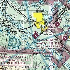
| Sectional chart |
|---|
|
| Airport distance calculator |
|---|
|
|
| Sunrise and sunset |
|---|
|
Times for 29-Jan-2026
| | Local
(UTC-8) | | Zulu
(UTC) |
|---|
| Morning civil twilight | | 06:45 | | 14:45 |
| Sunrise | | 07:13 | | 15:13 |
| Sunset | | 17:25 | | 01:25 |
| Evening civil twilight | | 17:53 | | 01:53 |
|
| Current date and time |
|---|
| Zulu (UTC) | 30-Jan-2026 02:31:29 |
|---|
| Local (UTC-8) | 29-Jan-2026 18:31:29 |
|---|
|
| METAR |
|---|
| KTCY | 300215Z AUTO 22003KT 10SM CLR 12/08 A3028 RMK A01
|
KC83
12nm NW | 300215Z AUTO 24007KT 10SM CLR 07/07 A3028 RMK AO2
|
KSCK
16nm NE | 300155Z 28004KT 10SM CLR 11/11 A3027 RMK AO2 SLP251 T01110111
|
KLVK
18nm W | 300153Z 09008KT 10SM CLR 12/07 A3027 RMK AO2 SLP250 T01220072
|
|
| TAF |
|---|
KSCK
16nm NE | 291724Z 2918/3018 09004KT 6SM BR FEW002 SCT250 FM292000 VRB04KT P6SM FEW250 FM300400 VRB02KT 3SM BR FEW010 FM300600 11003KT 1/4SM FG BKN001
|
KLVK
18nm W | 291720Z 2918/3018 08004KT P6SM SCT250
|
|
| NOTAMs |
|---|
NOTAMs are issued by the DoD/FAA and will open in a separate window not controlled by AirNav.
|
|


