FAA INFORMATION EFFECTIVE 19 FEBRUARY 2026
Location
| FAA Identifier: | TEL |
| Lat/Long: | 38-01-07.9000N 086-41-32.7000W
38-01.131667N 086-41.545000W
38.0188611,-86.6924167
(estimated) |
| Elevation: | 659.5 ft. / 201.0 m (surveyed) |
| Variation: | 02W (1995) |
| From city: | 6 miles NE of TELL CITY, IN |
| Time zone: | UTC -6 (UTC -5 during Daylight Saving Time) |
| Zip code: | 47586 |
Airport Operations
| Airport use: | Open to the public |
| Control tower: | no |
| ARTCC: | INDIANAPOLIS CENTER |
| FSS: | TERRE HAUTE FLIGHT SERVICE STATION |
| NOTAMs facility: | HUF (NOTAM-D service available) |
| Attendance: | UNATNDD |
| Wind indicator: | lighted |
| Segmented circle: | no |
| Lights: | ACTVT REIL RWY 13 & 31; MIRL RWY 13/31 - CTAF. PAPI RWY 13 & 31 H24. |
| Beacon: | white-green (lighted land airport)
Operates sunset to sunrise. |
Airport Communications
| CTAF/UNICOM: | 122.7 |
| EVANSVILLE APPROACH: | 124.025 [0530-0000 SUN-FRI, 0530-2345 SAT.] |
| EVANSVILLE DEPARTURE: | 124.025 [0530-0000 SUN-FRI, 0530-2345 SAT.] |
| WX AWOS-3 at KY8 (9 nm SW): | 119.775 (270-295-3565) |
| WX AWOS-3PT at I93 (18 nm SE): | 123.625 (270-580-4012) |
| WX AWOS-3PT at HNB (18 nm NW): | 118.250 (812-683-4003) |
- APCH/DEP SVC PRVDD BY INDIANAPOLIS ARTCC ON FREQS 128.3/291.625 (EVANSVILLE RCAG) WHEN EVANSVILLE APCH CTL CLSD.
Nearby radio navigation aids
| VOR radial/distance | | VOR name | | Freq | | Var |
|---|
| MYSr290/(22.5) | | MYSTIC VOR | | 108.20 | | 01W |
| OWBr058/27.9 | | OWENSBORO VOR/DME | | 108.65 | | 04W |
| FTKr282/34.7 | | FORT KNOX VOR/DME | | 109.60 | | 01W |
| NDB name | | Hdg/Dist | | Freq | | Var | | ID |
|---|
| GODMAN | | 279/34.0 | | 396 | | 03W | | GOI | --. --- .. |
Airport Services
| Fuel available: | 100LL MOGAS |
| Parking: | hangars and tiedowns |
| Bulk oxygen: | NONE |
Runway Information
Runway 13/31
| Dimensions: | 4400 x 75 ft. / 1341 x 23 m |
| Surface: | asphalt, in good condition |
| Weight bearing capacity: | |
| Runway edge lights: | medium intensity |
| RUNWAY 13 | | RUNWAY 31 |
| Latitude: | 38-01.381830N | | 38-00.879898N |
| Longitude: | 086-41.875223W | | 086-41.214068W |
| Elevation: | 608.0 ft. | | 659.5 ft. |
| Traffic pattern: | left | | left |
| Runway heading: | 136 magnetic, 134 true | | 316 magnetic, 314 true |
| Markings: | nonprecision, in good condition | | nonprecision, in good condition |
| Visual slope indicator: | 4-light PAPI on right (3.00 degrees glide path) | | 4-light PAPI on right (3.25 degrees glide path) |
| Runway end identifier lights: | yes | | yes |
| Touchdown point: | yes, no lights | | yes, no lights |
| Obstructions: | 20 ft. trees, 370 ft. from runway, 60 ft. right of centerline, 8:1 slope to clear
TREES 15-20' TALL 100' L OF CENTERLINE | | 43 ft. tree, 680 ft. from runway, 110 ft. left of centerline, 11:1 slope to clear
CROPS 5FT TALL AT 170FT R OF CL |
Airport Ownership and Management from official FAA records
| Ownership: | Publicly-owned |
| Owner: | PERRY COUNTY ARPT AUTH
11965 OLD STATE RD 37
TELL CITY, IN 47586
Phone 812-547-4101 |
| Manager: | KEN ROLAND
11965 OLD STATE RD 37
TELL CITY, IN 47586
Phone 812-608-0651 |
Additional Remarks
| - | SAWRS |
| - | FOR CD CTC EVANSVILLE APCH AT 812-436-4690, WHEN APCH CLSD CTC INDIANAPOLIS ARTCC AT 317-247-2411. |
| - | SELF SERV FUEL AVBL. |
Instrument Procedures
NOTE: All procedures below are presented as PDF files. If you need a reader for these files, you should download the free Adobe Reader.NOT FOR NAVIGATION. Please procure official charts for flight.
FAA instrument procedures published for use from 19 February 2026 at 0901Z to 19 March 2026 at 0900Z.
IAPs - Instrument Approach Procedures |
|---|
| RNAV (GPS) RWY 13 | |
download (210KB) |
| RNAV (GPS) RWY 31 | |
download (231KB) |
| NOTE: Special Take-Off Minimums/Departure Procedures apply | |
download (468KB) |
Other nearby airports with instrument procedures:
KY8 - Hancock County Airport/Ron Lewis Field (9 nm SW)
I93 - Breckinridge County Airport (18 nm SE)
KHNB - Huntingburg Airport (18 nm NW)
KOWB - Owensboro/Daviess County Regional Airport (28 nm SW)
KFRH - French Lick Municipal Airport (29 nm N)
|
|

Road maps at:
MapQuest
Bing
Google
| Aerial photo |
|---|
WARNING: Photo may not be current or correct
 Photo by Donn Wimmer
Taken in the Spring of 2007
Photo by Donn Wimmer
Taken in the Spring of 2007
Do you have a better or more recent aerial photo of Perry County Municipal Airport that you would like to share? If so, please send us your photo.
|
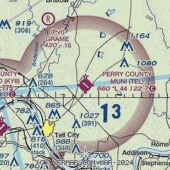
| Sectional chart |
|---|
|
| Airport distance calculator |
|---|
|
|
| Sunrise and sunset |
|---|
|
Times for 28-Feb-2026
| | Local
(UTC-6) | | Zulu
(UTC) |
|---|
| Morning civil twilight | | 05:54 | | 11:54 |
| Sunrise | | 06:21 | | 12:21 |
| Sunset | | 17:38 | | 23:38 |
| Evening civil twilight | | 18:04 | | 00:04 |
|
| Current date and time |
|---|
| Zulu (UTC) | 28-Feb-2026 20:09:50 |
|---|
| Local (UTC-6) | 28-Feb-2026 14:09:50 |
|---|
|
| METAR |
|---|
KKY8
9nm SW | 281955Z AUTO 00000KT 10SM CLR 21/00 A2999 RMK A01
|
KHNB
18nm NW | 281956Z AUTO 19007KT 10SM CLR 20/M01 A3001 RMK AO2 SLP159 T02001011
|
|
| TAF |
|---|
KHNB
18nm NW | 281720Z 2818/0118 VRB03KT P6SM SKC FM282300 22004KT P6SM OVC100 PROB30 0100/0106 -RA FM010800 35009KT P6SM SCT250
|
|
| NOTAMs |
|---|
NOTAMs are issued by the DoD/FAA and will open in a separate window not controlled by AirNav.
|
|

