FAA INFORMATION EFFECTIVE 14 MAY 2026
Location
| FAA Identifier: | TRX |
| Lat/Long: | 40-05-00.7000N 093-35-26.3000W
40-05.011667N 093-35.438333W
40.0835278,-93.5906389
(estimated) |
| Elevation: | 757.5 ft. / 230.9 m (surveyed) |
| Variation: | 03E (2000) |
| From city: | 1 mile E of TRENTON, MO |
| Time zone: | UTC -5 (UTC -6 during Standard Time) |
| Zip code: | 64683 |
Airport Operations
| Airport use: | Open to the public |
| Activation date: | 11/1965 |
| Control tower: | no |
| ARTCC: | KANSAS CITY CENTER |
| FSS: | COLUMBIA FLIGHT SERVICE STATION |
| NOTAMs facility: | COU (NOTAM-D service available) |
| Attendance: | MON-FRI 0730-1630 |
| Wind indicator: | lighted |
| Segmented circle: | no |
| Lights: | MIRL RY 18/36 & PAPI RYS 18 & 36 OPER DUSK-2130; AFT 2130 TO DUSK ACTVT MIRL RY 18/36, PAPI RYS 18 & 36, REIL RYS 18 & 36 - CTAF. TO INCR INTST & ACTVT REIL RYS 18 & 36 - CTAF. |
| Beacon: | white-green (lighted land airport)
Operates sunset to sunrise. |
Airport Communications
| CTAF/UNICOM: | 122.8 |
| WX AWOS-3 at CHT (19 nm S): | 118.175 (660-646-0713) |
- APCH/DEP SVC PRVDD BY KANSAS CITY ARTCC ON FREQS 125.25/235.975 (CHILLICOTHE RCAG).
Nearby radio navigation aids
| VOR radial/distance | | VOR name | | Freq | | Var |
|---|
| BQSr023/30.2 | | BRAYMER VOR/DME | | 115.35 | | 03E |
| LMNr144/35.3 | | LAMONI VOR/DME | | 116.70 | | 07E |
Airport Services
| Fuel available: | 100LL JET-A
100LL:24 HR FUEL AVBL; CTC AMGR (660)359-2013; AFTER HRS CTC FIRE DEPT (660)359-5552. |
| Parking: | tiedowns |
| Bottled oxygen: | NONE |
| Bulk oxygen: | NONE |
Runway Information
Runway 18/36
| Dimensions: | 4307 x 75 ft. / 1313 x 23 m |
| Surface: | asphalt, in good condition |
| Runway edge lights: | medium intensity |
| RUNWAY 18 | | RUNWAY 36 |
| Latitude: | 40-05.366402N | | 40-04.657017N |
| Longitude: | 093-35.444343W | | 093-35.432382W |
| Elevation: | 757.3 ft. | | 754.9 ft. |
| Traffic pattern: | left | | left |
| Runway heading: | 176 magnetic, 179 true | | 356 magnetic, 359 true |
| Displaced threshold: | 400 ft. | | no |
| Markings: | nonprecision, in good condition | | nonprecision, in good condition |
| Visual slope indicator: | 4-light PAPI on left (3.00 degrees glide path) | | 4-light PAPI on left (3.00 degrees glide path) |
| Runway end identifier lights: | yes | | yes |
| Touchdown point: | yes, no lights | | yes, no lights |
| Obstructions: | 15 ft. road, 240 ft. from runway, 260 ft. left and right of centerline, 2:1 slope to clear
42:1 TO DTHR. | | none |
Airport Ownership and Management from official FAA records
| Ownership: | Publicly-owned |
| Owner: | CITY OF TRENTON
1100 MAIN ST., PO BOX 188
TRENTON, MO 64683
Phone 660-359-2013 |
| Manager: | WESLEY BARONE
1100 MAIN ST., PO BOX 188
TRENTON, MO 64683
Phone (660) 359-2013 |
Additional Remarks
| A96 | ULTRALIGHT ACTIVITY ON & INVOF ARPT. |
| - | BE ALERT FOR BIRDS & WILDLIFE ON AND INVOF ARPT. |
| - | FOR CD CTC KANSAS CITY ARTCC AT 913-254-8508. |
Instrument Procedures
NOTE: All procedures below are presented as PDF files. If you need a reader for these files, you should download the free Adobe Reader.NOT FOR NAVIGATION. Please procure official charts for flight.
FAA instrument procedures published for use from 14 May 2026 at 0901Z to 11 June 2026 at 0900Z.
IAPs - Instrument Approach Procedures |
|---|
| RNAV (GPS) RWY 18 | |
download (216KB) |
| RNAV (GPS) RWY 36 | |
download (222KB) |
| NOTE: Special Take-Off Minimums/Departure Procedures apply | |
download (345KB) |
Other nearby airports with instrument procedures:
KCHT - Chillicothe Municipal Airport (19 nm S)
MO8 - North Central Missouri Regional Airport (33 nm SE)
KLWD - Lamoni Municipal Airport (36 nm NW)
KEZZ - Cameron Memorial Airport (38 nm SW)
KTVK - Centerville Municipal Airport (48 nm NE)
|
|

Road maps at:
MapQuest
Bing
Google
| Aerial photo |
|---|
WARNING: Photo may not be current or correct
 Photo by David Newcomer
Photo taken 31-Mar-2012
from 3,000' AGL looking northeast.
Photo by David Newcomer
Photo taken 31-Mar-2012
from 3,000' AGL looking northeast.
Do you have a better or more recent aerial photo of Trenton Municipal Airport that you would like to share? If so, please send us your photo.
|
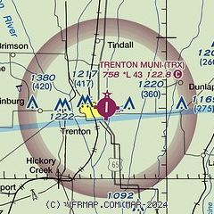
| Sectional chart |
|---|
|
| Airport distance calculator |
|---|
|
|
| Sunrise and sunset |
|---|
|
Times for 10-Jun-2026
| | Local
(UTC-5) | | Zulu
(UTC) |
|---|
| Morning civil twilight | | 05:13 | | 10:13 |
| Sunrise | | 05:46 | | 10:46 |
| Sunset | | 20:42 | | 01:42 |
| Evening civil twilight | | 21:14 | | 02:14 |
|
| Current date and time |
|---|
| Zulu (UTC) | 10-Jun-2026 11:13:31 |
|---|
| Local (UTC-5) | 10-Jun-2026 06:13:31 |
|---|
|
| METAR |
|---|
KCDJ
16nm S | 101051Z AUTO 18007KT 24/21 A2979 RMK AO1 SLP073 T02440211
|
|
| NOTAMs |
|---|
NOTAMs are issued by the DoD/FAA and will open in a separate window not controlled by AirNav.
|
|

