FAA INFORMATION EFFECTIVE 14 MAY 2026
Location
| FAA Identifier: | UAO |
| Lat/Long: | 45-14-49.6550N 122-46-12.1690W
45-14.827583N 122-46.202817W
45.2471264,-122.7700469
(estimated) |
| Elevation: | 199.6 ft. / 60.8 m (surveyed) |
| Variation: | 15E (2020) |
| From city: | 1 mile NW of AURORA, OR |
| Time zone: | UTC -7 (UTC -8 during Standard Time) |
| Zip code: | 97002 |
Airport Operations
| Airport use: | Open to the public |
| Activation date: | 12/1943 |
| Control tower: | yes |
| ARTCC: | SEATTLE CENTER |
| FSS: | MC MINNVILLE FLIGHT SERVICE STATION |
| NOTAMs facility: | UAO (NOTAM-D service available) |
| Attendance: | 0700-2000 |
| Wind indicator: | lighted |
| Segmented circle: | yes |
| Lights: | ACTVT MIRL RY 17/35, VASI RYS 17 & 35 AND ODALS RY 17 - CTAF. |
| Beacon: | white-green (lighted land airport)
Operates sunset to sunrise. |
Airport Communications
| CTAF: | 120.35 |
| ATIS: | 118.525 |
| WX ASOS: | 118.525 (503-678-3011) |
| AURORA TWR GROUND: | 119.15 [0700-2000] |
| AURORA TWR TOWER: | 120.35 [0700-2000] |
| PORTLAND APPROACH: | 118.1 ;HIGH 126.0 ;LOW |
| PORTLAND DEPARTURE: | 118.1 ;HIGH 126.0 ;LOW |
| CLEARANCE DELIVERY: | 119.15 119.95 ;WHEN TWR CLSD |
| HELNS STAR: | 124.35 |
| WX ASOS at MMV (16 nm W): | 135.675 (503-434-9153) |
| WX ASOS at HIO (19 nm NW): | PHONE 503-615-4314 |
Nearby radio navigation aids
| VOR radial/distance | | VOR name | | Freq | | Var |
|---|
| UBGr105/10.8 | | NEWBERG VOR/DME | | 117.40 | | 21E |
| BTGr173/31.0 | | BATTLE GROUND VORTAC | | 116.60 | | 21E |
| NDB name | | Hdg/Dist | | Freq | | Var | | ID |
|---|
| BANKS | | 137/25.8 | | 356 | | 16E | | PND | .--. -. -.. |
Airport Services
| Fuel available: | 100LL JET-A |
| Parking: | tiedowns |
| Airframe service: | MAJOR |
| Powerplant service: | MAJOR |
| Bottled oxygen: | NONE |
| Bulk oxygen: | HIGH |
Runway Information
Runway 17/35
| Dimensions: | 5003 x 100 ft. / 1525 x 30 m
RY 17/35 150 FT BLAST PAD AT SOUTH END. |
| Surface: | asphalt/grooved, in excellent condition |
| Weight bearing capacity: | | Single wheel: | 30.0 | | Double wheel: | 45.0 |
|
| Runway edge lights: | medium intensity |
| RUNWAY 17 | | RUNWAY 35 |
| Latitude: | 45-15.236045N | | 45-14.419122N |
| Longitude: | 122-46.130385W | | 122-46.275245W |
| Elevation: | 199.5 ft. | | 196.3 ft. |
| Traffic pattern: | left | | left |
| Runway heading: | 172 magnetic, 187 true | | 352 magnetic, 007 true |
| Markings: | precision, in good condition | | precision, in good condition |
| Visual slope indicator: | 4-box VASI on right (3.50 degrees glide path) | | 4-box VASI on left (3.25 degrees glide path) |
| Approach lights: | ODALS: omnidirectional approach lighting system | | |
| Touchdown point: | yes, no lights | | yes, no lights |
| Instrument approach: | LOC/DME | | |
| Obstructions: | 100 ft. trees, 2939 ft. from runway, 175 ft. right of centerline, 27:1 slope to clear | | 90 ft. tree, 1634 ft. from runway, 520 ft. left of centerline, 16:1 slope to clear |
Airport Ownership and Management from official FAA records
| Ownership: | Publicly-owned |
| Owner: | OREGON DEPT OF AVIATION
3040 25TH ST SE
SALEM, OR 97302-1125
Phone 503-378-4880 |
| Manager: | ANTHONY BEACH
3040 25TH ST SE
SALEM, OR 97302-1125
Phone 503-378-4880
ANTHONY.BEACH@ODAV.OREGON.GOV |
Additional Remarks
| - | RY 35 CALM WIND RY. USE ONLY PAVED SFCS. FREQUENT STRAIGHT IN INSTRUMENT APCH TFC TO RY 17. |
| - | OVERWEIGHT ACFT CTC OWNER PRIOR 503-378-4880 |
| - | RY 17 +30 FT PLINE 2100 FT FM THLD; MKD BY BALLS. |
| - | PARALLEL TWY 35 FT WIDE AND HAS MEDIUM INTENSITY TWY LGTS. |
| - | MIGRATORY BIRDS, COYOTES, AND DEER ON AND INVOF ARPT. |
| - | NOISE ABATEMENT SENS AREA: 2 MI N OF RWY 17; 1 MI SE OF RWY 35; HLF MI SW OF RWY 35. AVOID LOW LEVEL OVER-FLIGHTS OF RESIDENTIAL AREAS SRNDG ARPT WHENEVER POSS. |
| - | ALL TAXILANES NON STD WINGTIP CLNC. |
Instrument Procedures
NOTE: All procedures below are presented as PDF files. If you need a reader for these files, you should download the free Adobe Reader.NOT FOR NAVIGATION. Please procure official charts for flight.
FAA instrument procedures published for use from 14 May 2026 at 0901Z to 11 June 2026 at 0900z.
STARs - Standard Terminal Arrivals |
|---|
| HELNS SIX | |
download (192KB) |
IAPs - Instrument Approach Procedures |
|---|
| RNAV (GPS) RWY 17 | |
download (228KB) |
| RNAV (GPS) RWY 35 | |
download (229KB) |
| LOC RWY 17 | |
download (286KB) |
| NOTE: Special Alternate Minimums apply | |
download (128KB) |
Departure Procedures |
|---|
| GLARA TWO (RNAV) | |
download (147KB) |
| GNNET TWO (RNAV) | |
download (147KB) |
| NEWBERG TWO (RNAV) | |
download (157KB) |
| NOTE: Special Take-Off Minimums/Departure Procedures apply | |
download (223KB) |
Other nearby airports with instrument procedures:
KMMV - Mc Minnville Municipal Airport (16 nm W)
KHIO - Portland-Hillsboro Airport (19 nm NW)
KPDX - Portland International Airport (22 nm N)
KSLE - McNary Field Airport (23 nm SW)
KVUO - Pearson Field Airport (23 nm N)
|
|

Road maps at:
MapQuest
Bing
Google
| Aerial photo |
|---|
WARNING: Photo may not be current or correct
 Photo by Nathan Rogers
Taken in August 2008
of final approach onto Rwy. 35.
Photo by Nathan Rogers
Taken in August 2008
of final approach onto Rwy. 35.
Do you have a better or more recent aerial photo of Aurora State Airport that you would like to share? If so, please send us your photo.
|
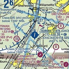
| Sectional chart |
|---|
|
| Airport distance calculator |
|---|
|
|
| Sunrise and sunset |
|---|
|
Times for 14-May-2026
| | Local
(UTC-7) | | Zulu
(UTC) |
|---|
| Morning civil twilight | | 05:09 | | 12:09 |
| Sunrise | | 05:43 | | 12:43 |
| Sunset | | 20:32 | | 03:32 |
| Evening civil twilight | | 21:06 | | 04:06 |
|
| Current date and time |
|---|
| Zulu (UTC) | 15-May-2026 03:13:18 |
|---|
| Local (UTC-7) | 14-May-2026 20:13:18 |
|---|
|
| METAR |
|---|
| KUAO | 150253Z 20005KT 3SM -RA BR FEW016 SCT024 OVC033 13/11 A3018 RMK AO2 RAB41 SLP220 P0001 60001 T01280111 55001
|
KMMV
16nm W | 150253Z AUTO 25009KT 10SM BKN045 OVC055 13/08 A3017 RMK AO2 RAB27E36 SLP216 P0000 60000 T01280078 53001
|
KHIO
20nm NW | 150253Z 23006KT 10SM FEW023 OVC044 13/10 A3016 RMK AO2 RAB06E52 SLP214 P0001 60001 T01280100 55001
|
|
| TAF |
|---|
| KUAO | 141720Z 1418/1518 23006KT P6SM BKN040 FM142300 27007KT P6SM VCSH OVC035 FM150300 23004KT P6SM BKN050
|
KHIO
20nm NW | 141720Z 1418/1518 23003KT P6SM VCSH SCT020 BKN035 FM142000 27008KT P6SM BKN050 FM142300 27006KT P6SM -SHRA OVC045 FM150400 VRB02KT P6SM SCT060
|
|
| NOTAMs |
|---|
NOTAMs are issued by the DoD/FAA and will open in a separate window not controlled by AirNav.
|
|

