FAA INFORMATION EFFECTIVE 16 APRIL 2026
Location
| FAA Identifier: | SLE |
| Lat/Long: | 44-54-34.3000N 123-00-09.0000W
44-54.571667N 123-00.150000W
44.9095278,-123.0025000
(estimated) |
| Elevation: | 213.4 ft. / 65.0 m (surveyed) |
| Variation: | 17E (2005) |
| From city: | 2 miles SE of SALEM, OR |
| Time zone: | UTC -7 (UTC -8 during Standard Time) |
| Zip code: | 97302 |
Airport Operations
| Airport use: | Open to the public |
| Activation date: | 11/1937 |
| Control tower: | yes |
| ARTCC: | SEATTLE CENTER |
| FSS: | MC MINNVILLE FLIGHT SERVICE STATION |
| NOTAMs facility: | SLE (NOTAM-D service available) |
| Attendance: | MON-FRI 0700-1900, ALL SAT-SUN 0700-1700 |
| Wind indicator: | lighted |
| Segmented circle: | yes |
| Lights: | WHEN ATCT CLSD ACTVT MALSR RWY 31; ODAL RWY 13; REIL RWY 13, 16, 34; HIRL RWY 13/31; MIRL RWY 16/34 - CTAF. REIL RWY 16, PAPI RWY 16 & 34 OTS INDEFLY. |
| Beacon: | white-green (lighted land airport)
Operates sunset to sunrise. |
| Landing fee: | yes, LDG FEE FOR COML & ITNRNTT WITH FAA CERTIFIED MAX GROSS LDG WT GTR THAN 7000 LB. |
| Fire and rescue: | ARFF index B |
| Airline operations: | PPR FOR UNSKED ACR OPS GTR THAN 30 PAX SEATS - AMGR. |
Airport Communications
| CTAF: | 119.1 |
| UNICOM: | 122.95 |
| ATIS: | 124.55 |
| WX ASOS: | 124.55 (458-322-0305) |
| SALEM GROUND: | 121.9 [0700-2100] |
| SALEM TOWER: | 119.1 257.2 [0700-2100] |
| EMERG: | 121.5 243.0 |
| NG OPS: | 142.8 248.5 40.9FM |
| WX AWOS-3PT at S12 (16 nm S): | 119.925 (541-967-3508) |
| WX ASOS at MMV (18 nm N): | 135.675 (503-434-9153) |
- APCH/DEP CTL SVC PRVDD BY SEATTLE ARTCC (ZSE) ON FREQS 125.8/291.7 (HORTON RCAG).
Nearby radio navigation aids
| VOR radial/distance | | VOR name | | Freq | | Var |
|---|
| UBGr161/26.6 | | NEWBERG VOR/DME | | 117.40 | | 21E |
| CVOr009/27.6 | | CORVALLIS VOR/DME | | 115.40 | | 18E |
| NDB name | | Hdg/Dist | | Freq | | Var | | ID |
|---|
| TURNO | | 313/4.3 | | 266 | | 17E | | SL | ... .-.. |
Airport Services
| Fuel available: | 100LL JET-A
A:AFT HR JET A PPR - 503-508-4178 OR 503-364-4158.
100LL:100 LL SELF SVC H24. |
| Parking: | hangars and tiedowns |
| Airframe service: | MAJOR |
| Powerplant service: | MAJOR |
| Bottled oxygen: | HIGH |
| Bulk oxygen: | HIGH |
Runway Information
Runway 13/31
| Dimensions: | 5811 x 150 ft. / 1771 x 46 m |
| Surface: | asphalt/grooved, in good condition |
| Weight bearing capacity: | | Single wheel: | 120.0 | | Double wheel: | 189.0 | | Double tandem: | 280.0 | | Dual double tandem: | 759.0 |
|
| Runway edge lights: | high intensity |
| RUNWAY 13 | | RUNWAY 31 |
| Latitude: | 44-55.012342N | | 44-54.183523N |
| Longitude: | 123-00.435210W | | 122-59.764205W |
| Elevation: | 194.5 ft. | | 213.4 ft. |
| Traffic pattern: | left | | left |
| Runway heading: | 133 magnetic, 150 true | | 313 magnetic, 330 true |
| Declared distances: | TORA:5811 TODA:5811 ASDA:5811 LDA:5811 | | TORA:5811 TODA:5811 ASDA:5811 LDA:5811 |
| Markings: | nonprecision, in good condition | | precision, in good condition |
| Visual slope indicator: | 4-box VASI on left (3.00 degrees glide path) | | |
| RVR equipment: | rollout | | touchdown |
| Approach lights: | ODALS: omnidirectional approach lighting system | | MALSR: 1,400 foot medium intensity approach lighting system with runway alignment indicator lights |
| Runway end identifier lights: | yes | | |
| Touchdown point: | yes, no lights | | yes, no lights |
| Instrument approach: | | | ILS/DME |
| Obstructions: | 11 ft. road, 600 ft. from runway, 550 ft. right of centerline, 36:1 slope to clear | | 459 ft. tree, 15950 ft. from runway, 1900 ft. left of centerline, 30:1 slope to clear |
Runway 16/34
| Dimensions: | 5146 x 100 ft. / 1569 x 30 m |
| Surface: | asphalt/grooved, in good condition |
| Weight bearing capacity: | | PCN 15 /F/D/X/T | | Single wheel: | 39.5 | | Double wheel: | 52.0 |
|
| Runway edge lights: | medium intensity |
| RUNWAY 16 | | RUNWAY 34 |
| Latitude: | 44-54.966695N | | 44-54.119958N |
| Longitude: | 123-00.198167W | | 123-00.214257W |
| Elevation: | 195.7 ft. | | 210.9 ft. |
| Traffic pattern: | left | | left |
| Runway heading: | 164 magnetic, 181 true | | 344 magnetic, 001 true |
| Declared distances: | TORA:5145 TODA:5145 ASDA:5145 LDA:5145 | | TORA:5145 TODA:5145 ASDA:5145 LDA:5145 |
| Markings: | nonprecision, in good condition | | nonprecision, in good condition |
| Visual slope indicator: | 4-light PAPI on left (3.00 degrees glide path) | | 4-light PAPI on left (4.00 degrees glide path) |
| Runway end identifier lights: | yes | | yes |
| Touchdown point: | yes, no lights | | yes, no lights |
| Obstructions: | 16 ft. road, 430 ft. from runway, 280 ft. left of centerline, 14:1 slope to clear | | 216 ft. tree, 4528 ft. from runway, 273 ft. right of centerline, 20:1 slope to clear |
Helipad H1
| Dimensions: | 37 x 37 ft. / 11 x 11 m |
| Surface: | concrete, in excellent condition |
| Latitude: | 44-54.443833N | | |
| Longitude: | 122-59.754333W | | |
| Elevation: | 213.4 ft. | | |
| Traffic pattern: | left | | left |
| Markings: | basic, in good condition | | |
Airport Ownership and Management from official FAA records
| Ownership: | Publicly-owned |
| Owner: | CITY OF SALEM
555 LIBERTY ST SE RM 220
SALEM, OR 97301
Phone 503-588-6314 |
| Manager: | AARON ISON
2990 25TH ST SE
SALEM, OR 97302
Phone 503-589-2057 |
Additional Remarks
| A39-13/31 | PCR VALUE: 510/F/C/X/T |
| - | ARNG: 1500-0030Z++ MON-FRI EXC HOL. TSNT PPR - D355-1401/ C971-355-1401; TSNT ALERT SVC & PRKG NA. ROTARY WING NOISE ABATEMENT PROC IN EFCT. TSNT ROTARY WING USE SANTIAM ARR/DEP. ARNG LGT ACFT PAX SVC VIP PAD S END OF MIL RAMP. DURG DUTY HR CTC GUARD OPS 10 MIN OUT - 40.90, 142.8, 248.5. OSA OPS - D355-1409/C971-355-1409. |
| - | FOR CD IF UNA TO CTC ON FSS FREQ, CTC SEATTLE ARTCC AT 253-351-3694. |
| - | CLSD AFT HVY SNOW. ARPT COND UNMNT 1600L-0800L & WKEND. |
| - | ACR OPS USE TWY A, TWY A1, TWY A2, TWY B, TWY C FM TWY A TO J, TWY F FM TWY A TO RWY 31, TWY J. |
| - | BIRD HAZ: WATERFOWL INVOF ARPT; GEESE TRSN CLASS D TPA OCT-MAY. |
| - | TWY A FM TWY L TO L9 NOT VSB FM ATCT. |
| - | NOISE ABATMENT PROC IN EFCT; AVOID OTFC RESIDENTIAL AREAS. |
| - | RISING TRRN & TREES W & S OF ARPT & RWY 34 EXTDD CNTRLN. TREES ON RWY 16 EXTDD CNTRLN. NGT OPS NOT RCMD BOTH RWYS. |
Instrument Procedures
NOTE: All procedures below are presented as PDF files. If you need a reader for these files, you should download the free Adobe Reader.NOT FOR NAVIGATION. Please procure official charts for flight.
FAA instrument procedures published for use from 16 April 2026 at 0901Z to 14 May 2026 at 0900Z.
IAPs - Instrument Approach Procedures |
|---|
| ILS OR LOC Z RWY 31 | |
download (302KB) |
| RNAV (GPS) RWY 13 | |
download (228KB) |
| RNAV (GPS) RWY 31 | |
download (330KB) |
| LOC Y RWY 31 | |
download (262KB) |
| LOC BC RWY 13 | |
download (242KB) |
| NOTE: Special Alternate Minimums apply | |
download (210KB) |
Departure Procedures |
|---|
| SALEM FOUR | |
download (266KB) |
| NOTE: Special Take-Off Minimums/Departure Procedures apply | |
download (566KB) |
Other nearby airports with instrument procedures:
S12 - Albany Municipal Airport (16 nm S)
KMMV - Mc Minnville Municipal Airport (18 nm N)
KUAO - Aurora State Airport (23 nm NE)
KCVO - Corvallis Municipal Airport (28 nm SW)
KHIO - Portland-Hillsboro Airport (38 nm N)
|
|

Road maps at:
MapQuest
Bing
Google
| Aerial photo |
|---|
WARNING: Photo may not be current or correct
 Photo by J.P. McLaughlin
Photo taken 18-Apr-2020
looking north-northwest.
Photo by J.P. McLaughlin
Photo taken 18-Apr-2020
looking north-northwest.
Do you have a better or more recent aerial photo of McNary Field Airport that you would like to share? If so, please send us your photo.
|
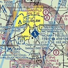
| Sectional chart |
|---|
|
CAUTION: Diagram may not be current
 Download PDF
of official airport diagram from the FAA
| Airport distance calculator |
|---|
|
|
| Sunrise and sunset |
|---|
|
Times for 01-May-2026
| | Local
(UTC-7) | | Zulu
(UTC) |
|---|
| Morning civil twilight | | 05:30 | | 12:30 |
| Sunrise | | 06:02 | | 13:02 |
| Sunset | | 20:16 | | 03:16 |
| Evening civil twilight | | 20:48 | | 03:48 |
|
| Current date and time |
|---|
| Zulu (UTC) | 01-May-2026 20:30:50 |
|---|
| Local (UTC-7) | 01-May-2026 13:30:50 |
|---|
|
| METAR |
|---|
| KSLE | 011956Z 27006KT 10SM CLR 19/10 A3001 RMK AO2 SLP163 T01940100
|
KMMV
18nm N | 011953Z AUTO 00000KT 10SM FEW120 19/11 A3001 RMK AO2 SLP163 T01890111 PNO $
|
|
| TAF |
|---|
| KSLE | 011737Z 0118/0218 VRB05KT P6SM BKN250 FM020200 30007KT P6SM BKN100
|
|
| NOTAMs |
|---|
NOTAMs are issued by the DoD/FAA and will open in a separate window not controlled by AirNav.
|
|


