FAA INFORMATION EFFECTIVE 14 MAY 2026
Location
| FAA Identifier: | VNC |
| Lat/Long: | 27-04-16.5640N 082-26-24.1170W
27-04.276067N 082-26.401950W
27.0712678,-82.4400325
(estimated) |
| Elevation: | 18.1 ft. / 5.5 m (surveyed) |
| Variation: | 05W (2010) |
| From city: | 2 miles S of VENICE, FL |
| Time zone: | UTC -4 (UTC -5 during Standard Time) |
| Zip code: | 34223 |
Airport Operations
| Airport use: | Open to the public |
| Activation date: | 07/1944 |
| Control tower: | no |
| ARTCC: | MIAMI CENTER |
| FSS: | SAINT PETERSBURG FLIGHT SERVICE STATION |
| NOTAMs facility: | PIE (NOTAM-D service available) |
| Attendance: | 0700-1900 |
| Wind indicator: | lighted |
| Segmented circle: | yes |
| Lights: | ACTVT REIL RWY 5, 23, & 13; MIRL RWY 5/23, 13/31 - CTAF. |
| Beacon: | white-green (lighted land airport)
Operates sunset to sunrise. |
Airport Communications
| CTAF/UNICOM: | 122.725 |
| WX AWOS-3: | 119.275 (941-486-2718) |
| TAMPA APPROACH: | 119.65 124.95 |
| TAMPA DEPARTURE: | 119.65 124.95 |
| CLEARANCE DELIVERY: | 118.075 |
| BANGZ STAR: | 118.8 |
| LUBBR STAR: | 135.5 |
| RAYZZ STAR: | 118.8 |
Nearby radio navigation aids
| VOR radial/distance | | VOR name | | Freq | | Var |
|---|
| SRQr167/21.2 | | SARASOTA VOR/DME | | 117.00 | | 05W |
Airport Services
| Fuel available: | 100LL JET-A |
| Parking: | hangars and tiedowns |
| Airframe service: | MAJOR |
| Powerplant service: | MAJOR |
| Bottled oxygen: | NONE |
| Bulk oxygen: | NONE |
Runway Information
Runway 13/31
| Dimensions: | 5640 x 150 ft. / 1719 x 46 m |
| Surface: | asphalt, in excellent condition |
| Weight bearing capacity: | | PCN 26 /F/A/X/T | | Single wheel: | 75.0 | | Double wheel: | 108.0 |
|
| Runway edge lights: | medium intensity |
| RUNWAY 13 | | RUNWAY 31 |
| Latitude: | 27-04.569480N | | 27-03.908740N |
| Longitude: | 082-26.813250W | | 082-26.080677W |
| Elevation: | 14.9 ft. | | 16.3 ft. |
| Traffic pattern: | right | | left |
| Runway heading: | 140 magnetic, 135 true | | 320 magnetic, 315 true |
| Displaced threshold: | 639 ft. | | 639 ft. |
| Declared distances: | TORA:5000 TODA:5000 ASDA:5000 LDA:5000 | | TORA:5000 TODA:5000 ASDA:5000 LDA:5000 |
| Markings: | nonprecision, in good condition | | nonprecision, in good condition |
| Visual slope indicator: | 4-light PAPI on left (3.00 degrees glide path) | | 4-light PAPI on left (3.00 degrees glide path) |
| Runway end identifier lights: | yes | | yes |
| Touchdown point: | yes, no lights | | yes, no lights |
| Obstructions: | 40 ft. trees, 1155 ft. from runway, 255 ft. right of centerline, 23:1 slope to clear
RWY 13 APCH SLOPE 45:1 TO DTHR. | | 45 ft. tree, 890 ft. from runway, 110 ft. right of centerline, 15:1 slope to clear
RWY 31 APCH SLOPE 34:1 TO DTHR. |
Runway 5/23
| Dimensions: | 5000 x 150 ft. / 1524 x 46 m |
| Surface: | asphalt, in good condition |
| Weight bearing capacity: | | PCN 26 /F/A/X/T | | Single wheel: | 75.0 | | Double wheel: | 108.0 |
|
| Runway edge lights: | medium intensity |
| RUNWAY 5 | | RUNWAY 23 |
| Latitude: | 27-04.027080N | | 27-04.608430N |
| Longitude: | 082-26.678367W | | 082-26.024008W |
| Elevation: | 12.4 ft. | | 17.4 ft. |
| Traffic pattern: | left | | left |
| Runway heading: | 050 magnetic, 045 true | | 230 magnetic, 225 true |
| Displaced threshold: | no | | 463 ft. |
| Declared distances: | | | TORA:5000 TODA:5000 ASDA:4840 LDA:4377 |
| Markings: | nonprecision, in good condition | | nonprecision, in good condition |
| Visual slope indicator: | 4-light PAPI on left (3.00 degrees glide path) | | 4-light PAPI on left (3.00 degrees glide path) |
| Runway end identifier lights: | yes | | yes |
| Touchdown point: | yes, no lights | | yes, no lights |
| Obstructions: | 14 ft. trees, 865 ft. from runway, 225 ft. left of centerline | | 55 ft. brdg, lighted, 1190 ft. from runway, 90 ft. left of centerline, 18:1 slope to clear
RWY 23 APCH RATIO 30:1 TO DTHR. |
Airport Ownership and Management from official FAA records
| Ownership: | Publicly-owned |
| Owner: | CITY OF VENICE
401 WEST VENICE AVE
VENICE, FL 34285
Phone 941-486-2626 |
| Manager: | NICHOLAS DUMAS
150 AIRPORT AVE EAST
VENICE, FL 34285
Phone 941-486-2711 |
Additional Remarks
| A30A-05 | RWY 05/23 PREF APCH. |
| A30A-23 | PREF DEP CALM WIND RWY. |
| E60-13 | ENGINEERED MATERIAL ARRESTING SYSTEM 260 FT IN LENGTH BY 165 FT IN WIDTH LCTD AT THE DER 13. |
| - | NOISE ABATEMENT PROCEDURES IN EFFECT, CALL AMGR 941-486-2711. |
| - | ARPT SFC CONDS NOT RPRTD. |
| - | FOR CD CTC TAMPA APCH AT 813-878-2528 |
| - | 24 HR PPR FOR ACFT EQUIPPED WITH WEATHER MODIFICATION OR GEOENGINEERING EQPT 941-486-2711. |
| - | ARPT HAS EXTENSIVE FLIGHT TRAINING. |
| - | BIRD AND WILDLIFE ON AND INVOF THE ARPT. |
| - | PAEW ADJ TO ALL RYS AND TWYS DURG DALGT HRS. |
| - | PPR FOR ACFT EXCEEDING RY WEIGHT BEARING CAPACITY. |
| - | PARASAILING ACTIVITY WEST THE ARPT ALONG BEACH. |
| - | RY 23 IS CALM WIND RY. |
Instrument Procedures
NOTE: All procedures below are presented as PDF files. If you need a reader for these files, you should download the free Adobe Reader.NOT FOR NAVIGATION. Please procure official charts for flight.
FAA instrument procedures published for use from 14 May 2026 at 0901Z to 11 June 2026 at 0900Z.
STARs - Standard Terminal Arrivals |
|---|
| BANGZ TWO (RNAV) | |
2 pages:
[1] [2] (424KB) |
| LUBBR FOUR (RNAV) | |
2 pages:
[1] [2] (420KB) |
| RAYZZ THREE (RNAV) | |
2 pages:
[1] [2] (443KB) |
IAPs - Instrument Approach Procedures |
|---|
| RNAV (GPS) RWY 05 | |
download (219KB) |
| RNAV (GPS) RWY 13 | |
download (211KB) |
| RNAV (GPS) RWY 23 | |
download (227KB) |
| RNAV (GPS) RWY 31 | |
download (213KB) |
| NOTE: Special Alternate Minimums apply | |
download (41KB) |
Departure Procedures |
|---|
| TIDES ONE (RNAV) | |
2 pages:
[1] [2] (316KB) |
| NOTE: Special Take-Off Minimums/Departure Procedures apply | |
download (408KB) |
Other nearby airports with instrument procedures:
FA54 - Coral Creek Airport (16 nm SE)
KSRQ - Sarasota/Bradenton International Airport (20 nm N)
KPGD - Punta Gorda Airport (26 nm E)
X06 - Arcadia Municipal Airport (33 nm E)
KCHN - Wauchula Municipal Airport (40 nm NE)
|
|

Road maps at:
MapQuest
Bing
Google
| Aerial photo |
|---|
WARNING: Photo may not be current or correct
 Photo taken 16-Feb-2013
looking northeast at 10,000 ft.
Photo taken 16-Feb-2013
looking northeast at 10,000 ft.
Do you have a better or more recent aerial photo of Venice Municipal Airport that you would like to share? If so, please send us your photo.
|
| Sectional chart |
|---|
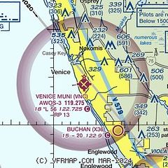
|
| Airport distance calculator |
|---|
|
|
| Sunrise and sunset |
|---|
|
Times for 04-Jun-2026
| | Local
(UTC-4) | | Zulu
(UTC) |
|---|
| Morning civil twilight | | 06:10 | | 10:10 |
| Sunrise | | 06:36 | | 10:36 |
| Sunset | | 20:20 | | 00:20 |
| Evening civil twilight | | 20:46 | | 00:46 |
|
| Current date and time |
|---|
| Zulu (UTC) | 05-Jun-2026 01:52:28 |
|---|
| Local (UTC-4) | 04-Jun-2026 21:52:28 |
|---|
|
| METAR |
|---|
| KVNC | 050135Z AUTO 09009KT 10SM OVC085 26/17 A3005 RMK AO2 T02600171 $
|
|
| TAF |
|---|
KSRQ
21nm N | 042158Z 0422/0518 10010KT P6SM OVC060 FM051300 10011KT P6SM FEW040 SCT250
|
KPGD
25nm E | 041738Z 0418/0518 09010G18KT P6SM SCT040 OVC100 PROB30 0418/0423 5SM -TSRA BKN030CB FM050300 08009KT P6SM SCT040 OVC100 FM051500 10012KT P6SM SCT050 BKN250
|
|
| NOTAMs |
|---|
NOTAMs are issued by the DoD/FAA and will open in a separate window not controlled by AirNav.
|
|


