FAA INFORMATION EFFECTIVE 14 MAY 2026
Location
| FAA Identifier: | PGD |
| Lat/Long: | 26-55-06.9330N 081-59-27.1900W
26-55.115550N 081-59.453167W
26.9185925,-81.9908861
(estimated) |
| Elevation: | 25.5 ft. / 7.8 m (surveyed) |
| Variation: | 06W (2020) |
| From city: | 3 miles SE of PUNTA GORDA, FL |
| Time zone: | UTC -4 (UTC -5 during Standard Time) |
| Zip code: | 33982 |
Airport Operations
| Airport use: | Open to the public |
| Activation date: | 02/1944 |
| Control tower: | yes |
| ARTCC: | MIAMI CENTER |
| FSS: | SAINT PETERSBURG FLIGHT SERVICE STATION |
| NOTAMs facility: | PGD (NOTAM-D service available) |
| Attendance: | CONTINUOUS |
| Wind indicator: | lighted |
| Segmented circle: | yes |
| Lights: | ACTVT REIL RWY 04, 15, 22 & 33; PAPI RWY 04, 15, 22 & 33 - CTAF. HIRL RWY 04/22; MIRL RWY 15/33 PRESET ON LOW INTST; TO INCR INTST - CTAF. |
| Beacon: | white-green (lighted land airport)
Operates sunset to sunrise. |
| Fire and rescue: | ARFF index B |
Airport Communications
| CTAF: | 121.0 |
| UNICOM: | 122.975 |
| ATIS: | 135.675 |
| WX ASOS: | 135.675 (941-639-0076) |
| PUNTA GORDA GROUND: | 119.55 [0600-2100] |
| PUNTA GORDA TOWER: | 121.0 [0600-2100] |
| FORT MYERS APPROACH: | 127.05 |
| FORT MYERS DEPARTURE: | 127.05 |
| CLEARANCE DELIVERY: | 127.05 ;WHEN TWR CLSD 119.55 |
| LUBBR STAR: | 119.65 |
| PIKKR STAR: | 127.05 ;5000 FT & BLO 134.425 ;6000 FT & ABV |
- APCH/DEP SVC PRVDD BY MIAMI ARTCC ON FREQS 134.75/322.5 (FORT MYERS RCAG) WHEN FORT MYERS APCH CTL CLSD.
- WHEN ATCT CLSD CLNC DEL 127.05 MONITORED BY FORT MYERS APCH CTL.
Nearby radio navigation aids
| VOR radial/distance | | VOR name | | Freq | | Var |
|---|
| RSWr336/26.0 | | LEE COUNTY VORTAC | | 114.15 | | 02W |
Airport Services
| Fuel available: | 100LL JET-A JET-A+
100LL:FUEL 24 HR CREDIT CARD SVC AVBL. |
| Parking: | hangars and tiedowns |
| Airframe service: | MAJOR |
| Powerplant service: | MAJOR |
| Bottled oxygen: | NONE |
| Bulk oxygen: | HIGH/LOW |
Runway Information
Runway 4/22
| Dimensions: | 7193 x 150 ft. / 2192 x 46 m |
| Surface: | asphalt/grooved, in fair condition |
| Weight bearing capacity: | | Single wheel: | 45.0 | | Double wheel: | 95.0 | | Double tandem: | 150.0 | | Dual double tandem: | 420.0 |
|
| Runway edge lights: | high intensity |
| RUNWAY 4 | | RUNWAY 22 |
| Latitude: | 26-54.610867N | | 26-55.647472N |
| Longitude: | 081-59.528750W | | 081-58.883232W |
| Elevation: | 23.2 ft. | | 25.4 ft. |
| Traffic pattern: | left | | left |
| Runway heading: | 035 magnetic, 029 true | | 215 magnetic, 209 true |
| Markings: | precision, in good condition | | nonprecision, in good condition |
| Visual slope indicator: | 4-light PAPI on left (3.00 degrees glide path) | | 4-light PAPI on left (3.00 degrees glide path) |
| Runway end identifier lights: | yes | | yes |
| Touchdown point: | yes, no lights | | yes, no lights |
| Instrument approach: | ILS/DME | | |
| Obstructions: | none | | 31 ft. trees, 1770 ft. from runway, 390 ft. right of centerline |
Runway 15/33
| Dimensions: | 6286 x 150 ft. / 1916 x 46 m |
| Surface: | asphalt/grooved, in excellent condition |
| Weight bearing capacity: | | Single wheel: | 45.0 | | Double wheel: | 80.0 | | Double tandem: | 140.0 |
|
| Runway edge lights: | medium intensity |
| RUNWAY 15 | | RUNWAY 33 |
| Latitude: | 26-55.420403N | | 26-54.529477N |
| Longitude: | 081-59.951298W | | 081-59.358280W |
| Elevation: | 18.5 ft. | | 23.0 ft. |
| Traffic pattern: | left | | left |
| Runway heading: | 155 magnetic, 149 true | | 335 magnetic, 329 true |
| Displaced threshold: | 271 ft. | | no |
| Declared distances: | TORA:6286 TODA:6286 ASDA:6286 LDA:6015 | | TORA:6166 TODA:6166 ASDA:6015 LDA:6015 |
| Markings: | nonprecision, in good condition | | nonprecision, in good condition |
| Visual slope indicator: | 4-light PAPI on left (3.00 degrees glide path) | | 4-light PAPI on left (3.00 degrees glide path) |
| Runway end identifier lights: | yes | | yes |
| Touchdown point: | yes, no lights | | yes, no lights |
| Obstructions: | 15 ft. road, 460 ft. from runway, 500 ft. right of centerline, 17:1 slope to clear
RWY 15 APCH SLP 48:1 TO DTHR. | | 54 ft. trees, 2375 ft. from runway, 60 ft. right of centerline, 40:1 slope to clear |
Runway 9/27
| Dimensions: | 2636 x 60 ft. / 803 x 18 m |
| Surface: | asphalt, in good condition |
| Operational restrictions: | RWY 09/27 NOT AVBL FOR PART 121/PART 380 OPS WITH SKED PAX CARRYING OPS MORE THAN 9 PAX SEATS AND NON-SKED PAX CARRYING OPS MORE THAN 30 PAX SEATS. RSTRD TO ACFT LESS THAN 6000 LBS. |
| RUNWAY 9 | | RUNWAY 27 |
| Latitude: | 26-55.410525N | | 26-55.416797N |
| Longitude: | 081-59.889478W | | 081-59.404143W |
| Elevation: | 19.1 ft. | | 22.1 ft. |
| Traffic pattern: | left | | left |
| Runway heading: | 095 magnetic, 089 true | | 275 magnetic, 269 true |
| Declared distances: | TORA:2635 TODA:2635 ASDA:2635 LDA:2635 | | TORA:2635 TODA:2635 ASDA:2635 LDA:2635 |
| Markings: | basic, in good condition | | basic, in good condition |
| Touchdown point: | yes, no lights | | yes, no lights |
| Obstructions: | 40 ft. trees, 2210 ft. from runway, 250 ft. left of centerline | | none |
Airport Ownership and Management from official FAA records
| Ownership: | Publicly-owned |
| Owner: | CHARLOTTE COUNTY ARPT AUTH
28000 A-1 AIRPORT RD
PUNTA GORDA, FL 33982
Phone 941-639-1101 |
| Manager: | JAMES W PARISH
28000 A-1 AIRPORT RD
PUNTA GORDA, FL 33982
Phone 941-639-1101
941-639-1101 EXT123. |
Additional Remarks
| A39-09/27 | PCR VALUE: 100/F/C/X/T |
| A39-04/22 | PCR VALUE: 570/F/B/X/T |
| A39-15/33 | PCR VALUE: 660/F/A/X/T |
| - | FOR CD IF UNA TO CTC ON FSS FREQ, CTC FT MYERS APCH AT 239-416-1026, WHEN APCH CLSD CTC MIAMI ARTCC AT 305-716-1731. |
| - | NO ROTOR-WING FUELING AT SELF SERVE |
| - | 24 HR PPR FOR ACFT EQUIPPED WITH WEATHER MODIFICATION OR GEOENGINEERING EQPT 941-815-7629. |
Instrument Procedures
NOTE: All procedures below are presented as PDF files. If you need a reader for these files, you should download the free Adobe Reader.NOT FOR NAVIGATION. Please procure official charts for flight.
FAA instrument procedures published for use from 14 May 2026 at 0901Z to 11 June 2026 at 0900Z.
STARs - Standard Terminal Arrivals |
|---|
| LUBBR FOUR (RNAV) | |
2 pages:
[1] [2] (420KB) |
| PIKKR SEVEN (RNAV) | |
download (204KB) |
IAPs - Instrument Approach Procedures |
|---|
| ILS OR LOC RWY 04 | |
download (298KB) |
| RNAV (GPS) RWY 04 | |
download (260KB) |
| RNAV (GPS) RWY 15 | |
download (267KB) |
| RNAV (GPS) RWY 22 | |
download (255KB) |
| RNAV (GPS) RWY 33 | |
download (252KB) |
| NOTE: Special Alternate Minimums apply | |
download (148KB) |
| NOTE: Special Take-Off Minimums/Departure Procedures apply | |
download (406KB) |
Other nearby airports with instrument procedures:
FA54 - Coral Creek Airport (15 nm W)
X06 - Arcadia Municipal Airport (18 nm NE)
KFMY - Page Field Airport (21 nm S)
KVNC - Venice Municipal Airport (26 nm W)
KRSW - Southwest Florida International Airport (26 nm SE)
|
|

Road maps at:
MapQuest
Bing
Google
| Aerial photo |
|---|
WARNING: Photo may not be current or correct
 Photo by Dave Fogarty CFI-AI
Photo taken 05-Dec-2011
looking south from 9,000'.
Photo by Dave Fogarty CFI-AI
Photo taken 05-Dec-2011
looking south from 9,000'.
Do you have a better or more recent aerial photo of Punta Gorda Airport that you would like to share? If so, please send us your photo.
|
| Sectional chart |
|---|
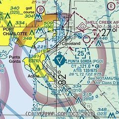
|
CAUTION: Diagram may not be current

| Airport distance calculator |
|---|
|
|
| Sunrise and sunset |
|---|
|
Times for 07-Jun-2026
| | Local
(UTC-4) | | Zulu
(UTC) |
|---|
| Morning civil twilight | | 06:08 | | 10:08 |
| Sunrise | | 06:34 | | 10:34 |
| Sunset | | 20:19 | | 00:19 |
| Evening civil twilight | | 20:45 | | 00:45 |
|
| Current date and time |
|---|
| Zulu (UTC) | 07-Jun-2026 17:17:04 |
|---|
| Local (UTC-4) | 07-Jun-2026 13:17:04 |
|---|
|
| METAR |
|---|
| KPGD | 071653Z 05006KT 10SM SCT042 BKN065 32/21 A3001 RMK AO2 SLP161 T03220211
|
|
| TAF |
|---|
| KPGD | 071133Z 0712/0812 09007KT P6SM SCT040 BKN250 FM080100 VRB03KT P6SM BKN050
|
|
| NOTAMs |
|---|
NOTAMs are issued by the DoD/FAA and will open in a separate window not controlled by AirNav.
|
|


