FAA INFORMATION EFFECTIVE 14 MAY 2026
Location
| FAA Identifier: | X06 |
| Lat/Long: | 27-11-43.1450N 081-50-17.6190W
27-11.719083N 081-50.293650W
27.1953181,-81.8382275
(estimated) |
| Elevation: | 63 ft. / 19 m (estimated) |
| Variation: | 06W (2015) |
| From city: | 1 mile SE of ARCADIA, FL |
| Time zone: | UTC -4 (UTC -5 during Standard Time) |
| Zip code: | 34266 |
Airport Operations
| Airport use: | Open to the public |
| Activation date: | 07/1940 |
| Control tower: | no |
| ARTCC: | MIAMI CENTER |
| FSS: | SAINT PETERSBURG FLIGHT SERVICE STATION |
| NOTAMs facility: | PIE (NOTAM-D service available) |
| Attendance: | 0800-1700 |
| Wind indicator: | lighted |
| Segmented circle: | no |
| Lights: | ACTVT PAPI RWY 06 & 24; MIRL RWY 06/24 - CTAF. |
| Beacon: | white-green (lighted land airport)
Operates sunset to sunrise. |
Airport Communications
| CTAF/UNICOM: | 123.0 |
| WX ASOS at PGD (18 nm SW): | 135.675 (941-639-0076) |
| WX AWOS-2 at CHN (19 nm N): | 118.35 (863-767-0559) |
- APCH/DEP SVC PRVDD BY MIAMI ARTCC (ZMA) ON FREQS 134.55/257.7 (AVON PARK RCAG).
Airport Services
| Fuel available: | 100LL |
| Parking: | tiedowns |
| Airframe service: | MAJOR |
| Powerplant service: | MAJOR |
| Bottled oxygen: | NONE |
| Bulk oxygen: | NONE |
Runway Information
Runway 6/24
| Dimensions: | 3700 x 75 ft. / 1128 x 23 m |
| Surface: | asphalt, in excellent condition |
| Weight bearing capacity: | |
| Runway edge lights: | medium intensity |
| RUNWAY 6 | | RUNWAY 24 |
| Latitude: | 27-11.550253N | | 27-11.922780N |
| Longitude: | 081-50.504257W | | 081-49.963140W |
| Elevation: | 58.9 ft. | | 61.6 ft. |
| Traffic pattern: | left | | left |
| Runway heading: | 058 magnetic, 052 true | | 238 magnetic, 232 true |
| Markings: | nonprecision, in good condition | | nonprecision, in good condition |
| Visual slope indicator: | 2-light PAPI on left (3.00 degrees glide path) | | 2-light PAPI on left (3.00 degrees glide path) |
| Runway end identifier lights: | yes | | yes |
| Touchdown point: | yes, no lights | | yes, no lights |
| Obstructions: | 15 ft. road, 585 ft. from runway, 125 ft. right of centerline, 25:1 slope to clear | | 59 ft. trees, 1455 ft. from runway, 135 ft. right of centerline, 21:1 slope to clear |
Runway 14/32
| Dimensions: | 2400 x 100 ft. / 732 x 30 m |
| Surface: | turf, in good condition |
| Runway edge markings: | THR OUTLINED BY WHITE CONES. |
| RUNWAY 14 | | RUNWAY 32 |
| Latitude: | 27-11.828123N | | 27-11.556257N |
| Longitude: | 081-50.547138W | | 081-50.224940W |
| Elevation: | 61.7 ft. | | 58.0 ft. |
| Traffic pattern: | left | | left |
| Runway heading: | 139 magnetic, 133 true | | 319 magnetic, 313 true |
| Displaced threshold: | 775 ft. | | 743 ft.
MKD WITH 3 WHITE CONES. |
| Markings: | NSTD, in fair condition | | NSTD, in fair condition |
| Touchdown point: | yes, no lights | | yes, no lights |
| Obstructions: | 38 ft. tree, 385 ft. from runway, 125 ft. left of centerline, 10:1 slope to clear
RWY 14 APCH RATIO 25:1 TO DTHR. | | 54 ft. trees, 535 ft. from runway, 10:1 slope to clear
RWY 32 APCH RATIO 23:1 TO DTHR. |
Airport Ownership and Management from official FAA records
| Ownership: | Publicly-owned |
| Owner: | CITY OF ARCADIA
P.O BOX 1000
ARCADIA, FL 33821
Phone 863-494-4114 |
| Manager: | SHELLEY PEACOCK
2269 SE AC POLK JR DR
ARCADIA, FL 34266
Phone 863-494-7844
ALT PH #: 863-993-5670 |
Additional Remarks
| - | FOR CD CTC MIAMI ARTCC AT 305-716-1731. |
Instrument Procedures
NOTE: All procedures below are presented as PDF files. If you need a reader for these files, you should download the free Adobe Reader.NOT FOR NAVIGATION. Please procure official charts for flight.
FAA instrument procedures published for use from 14 May 2026 at 0901Z to 11 June 2026 at 0900Z.
IAPs - Instrument Approach Procedures |
|---|
| RNAV (GPS)-A | |
download (210KB) |
| RNAV (GPS)-B | |
download (187KB) |
| NOTE: Special Take-Off Minimums/Departure Procedures apply | |
download (406KB) |
Other nearby airports with instrument procedures:
KPGD - Punta Gorda Airport (18 nm SW)
KCHN - Wauchula Municipal Airport (19 nm N)
KAVO - Avon Park Executive Airport (29 nm NE)
FA54 - Coral Creek Airport (30 nm SW)
KSEF - Sebring Regional Airport (31 nm NE)
|
|

Road maps at:
MapQuest
Bing
Google
| Aerial photo |
|---|
WARNING: Photo may not be current or correct
 Photo by George Chase
Photo taken 31-Dec-2009
Photo by George Chase
Photo taken 31-Dec-2009
Do you have a better or more recent aerial photo of Arcadia Municipal Airport that you would like to share? If so, please send us your photo.
|
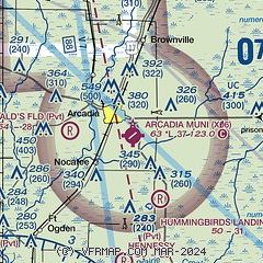
| Sectional chart |
|---|
|
CAUTION: Diagram may not be current

| Airport distance calculator |
|---|
|
|
| Sunrise and sunset |
|---|
|
Times for 31-May-2026
| | Local
(UTC-4) | | Zulu
(UTC) |
|---|
| Morning civil twilight | | 06:08 | | 10:08 |
| Sunrise | | 06:34 | | 10:34 |
| Sunset | | 20:16 | | 00:16 |
| Evening civil twilight | | 20:42 | | 00:42 |
|
| Current date and time |
|---|
| Zulu (UTC) | 31-May-2026 07:40:50 |
|---|
| Local (UTC-4) | 31-May-2026 03:40:50 |
|---|
|
| METAR |
|---|
KPGD
19nm SW | 310653Z AUTO 18003KT 10SM CLR 24/23 A2998 RMK AO2 SLP150 T02390233
|
|
| TAF |
|---|
KPGD
19nm SW | 310520Z 3106/0106 VRB03KT P6SM OVC150 FM311600 26008KT P6SM SCT040 BKN150 FM010100 VRB04KT P6SM SCT020 BKN150
|
|
| NOTAMs |
|---|
NOTAMs are issued by the DoD/FAA and will open in a separate window not controlled by AirNav.
|
|


