FAA INFORMATION EFFECTIVE 20 MARCH 2025
Location
| FAA Identifier: | MCW |
| Lat/Long: | 43-09-28.1000N 093-19-52.5000W
43-09.468333N 093-19.875000W
43.1578056,-93.3312500
(estimated) |
| Elevation: | 1213.4 ft. / 369.8 m (surveyed) |
| Variation: | 00E (2020) |
| From city: | 5 miles W of MASON CITY, IA |
| Time zone: | UTC -5 (UTC -6 during Standard Time) |
| Zip code: | 50428 |
Airport Operations
| Airport use: | Open to the public |
| Activation date: | 03/1943 |
| Control tower: | no |
| ARTCC: | MINNEAPOLIS CENTER |
| FSS: | FORT DODGE FLIGHT SERVICE STATION |
| NOTAMs facility: | MCW (NOTAM-D service available) |
| Attendance: | 0700-1700
FOR SVC OR FUEL AFT HRS PPR CALL 641-430-9898. |
| Pattern altitude: | 2013.4 ft. MSL |
| Wind indicator: | lighted |
| Segmented circle: | yes |
| Lights: | ACTVT HIRL RY 18/36; MIRL RY 12/30; REIL RY 12; MALS RY 18; MALSR RY 36; VASI RY 18; PAPI RYS 12; 30; & 36 - CTAF. ALL PAPIS ON DURG DALGT HRS. |
| Beacon: | white-green (lighted land airport)
Operates sunset to sunrise. |
| Fire and rescue: | ARFF index A |
| Airline operations: | INDEX B PROVIDED. |
Airport Communications
| CTAF/UNICOM: | 123.0 |
| WX ASOS: | 120.300 (641-255-0381) |
| WX AWOS-3 at FXY (14 nm W): | 123.925 (641-581-2347) |
- APCH/DEP SVC PRVDD BY MINNEAPOLIS ARTCC ON FREQS 127.3/257.675 (MASON CITY RCAG).
Nearby radio navigation aids
| VOR radial/distance | | VOR name | | Freq | | Var |
|---|
| MCWr353/3.8 | | MASON CITY VOR/DME | | 114.90 | | 06E |
| AELr176/31.5 | | ALBERT LEA VOR/DME | | 109.80 | | 01E |
Airport Services
| Fuel available: | 100LL JET-A |
| Parking: | hangars and tiedowns |
| Airframe service: | MAJOR |
| Powerplant service: | MAJOR |
Runway Information
Runway 18/36
| Dimensions: | 6501 x 150 ft. / 1982 x 46 m |
| Surface: | asphalt/grooved, in good condition |
| Weight bearing capacity: | | PCN 58 /F/C/X/T | | Single wheel: | 80.0 | | Double wheel: | 110.0 | | Double tandem: | 180.0 |
|
| Runway edge lights: | high intensity |
| RUNWAY 18 | | RUNWAY 36 |
| Latitude: | 43-10.118162N | | 43-09.047988N |
| Longitude: | 093-19.662812W | | 093-19.660723W |
| Elevation: | 1213.1 ft. | | 1192.9 ft. |
| Traffic pattern: | left | | left |
| Runway heading: | 180 | | 360 |
| Declared distances: | TORA:6501 TODA:6501 ASDA:6501 LDA:6501 | | TORA:6501 TODA:6501 ASDA:6401 LDA:6401 |
| Markings: | nonprecision, in good condition | | precision, in good condition |
| Visual slope indicator: | 4-box VASI on left (3.00 degrees glide path) | | 4-light PAPI on left (2.90 degrees glide path) |
| Approach lights: | MALS: 1,400 foot medium intensity approach lighting system | | MALSR: 1,400 foot medium intensity approach lighting system with runway alignment indicator lights |
| Touchdown point: | yes, no lights | | yes, no lights |
| Instrument approach: | | | ILS |
Runway 12/30
| Dimensions: | 5502 x 150 ft. / 1677 x 46 m |
| Surface: | asphalt/grooved, in excellent condition |
| Weight bearing capacity: | | PCN 45 /F/C/X/T | | Single wheel: | 80.0 | | Double wheel: | 110.0 | | Double tandem: | 180.0 |
|
| Runway edge lights: | medium intensity |
| RUNWAY 12 | | RUNWAY 30 |
| Latitude: | 43-09.590437N | | 43-09.071897N |
| Longitude: | 093-20.634967W | | 093-19.620938W |
| Elevation: | 1209.7 ft. | | 1192.1 ft. |
| Traffic pattern: | left | | left |
| Runway heading: | 125 | | 305 |
| Declared distances: | TORA:5501 TODA:5501 ASDA:5501 LDA:5501 | | TORA:5501 TODA:5501 ASDA:5501 LDA:5501 |
| Markings: | nonprecision, in good condition | | nonprecision, in good condition |
| Visual slope indicator: | 4-light PAPI on left (3.00 degrees glide path) | | 4-light PAPI on left (3.00 degrees glide path) |
| Runway end identifier lights: | yes | | |
| Touchdown point: | yes, no lights | | yes, no lights |
| Obstructions: | 63 ft. tree, 1700 ft. from runway, 150 ft. left of centerline, 23:1 slope to clear | | 41 ft. bldg, 1650 ft. from runway, 450 ft. right of centerline, 35:1 slope to clear |
Airport Ownership and Management from official FAA records
| Ownership: | Publicly-owned |
| Owner: | CITY OF MASON CITY
9184 - 265TH STREET
MASON CITY, IA 50428-1484
Phone 641-421-3397 |
| Manager: | DAVID K. SIMS
9184 - 265TH STREET
CLEAR LAKE, IA 50428-1484
Phone 641-421-3397 |
Additional Remarks
| - | BIRD ACTVTY ON & INVOF ARPT. |
| - | LANDING FEE FOR ALL COMMERCIAL OPERATED ACFT. |
| - | DUE TO RY & TWY END ELEV DIFFERENTIALS & ACFT HEIGHT; PILOTS MAY LOSE LINE OF SIGHT OF OTHER ACFT ON OPPOSING RY & TWY ENDS. ALL DEP/ARR ACFT USE CTAF. |
| - | RY 30 IS CALM WIND RY. |
| - | AIRPORT OPERATIONS 641-430-0980. |
| - | FOR CD IF UNA TO CTC ON FSS FREQ, CTC MINNEAPOLIS ARTCC AT 651-463-5588. |
Instrument Procedures
NOTE: All procedures below are presented as PDF files. If you need a reader for these files, you should download the free Adobe Reader.NOT FOR NAVIGATION. Please procure official charts for flight.
FAA instrument procedures published for use from 20 March 2025 at 0901Z to 17 April 2025 at 0900z.
IAPs - Instrument Approach Procedures |
|---|
| ILS OR LOC RWY 36 | |
download (263KB) |
| RNAV (GPS) RWY 12 | |
download (232KB) |
| RNAV (GPS) RWY 18 | |
download (276KB) |
| RNAV (GPS) RWY 30 | |
download (276KB) |
| RNAV (GPS) RWY 36 | |
download (295KB) |
| VOR RWY 36 | |
download (220KB) |
| NOTE: Special Alternate Minimums apply | |
download (146KB) |
| NOTE: Special Take-Off Minimums/Departure Procedures apply | |
download (234KB) |
Other nearby airports with instrument procedures:
KFXY - Forest City Municipal Airport/Trimble Field (14 nm W)
KHPT - Hampton Municipal Airport (26 nm S)
KCAV - Clarion Municipal Airport (31 nm SW)
KAEL - Albert Lea Municipal Airport (31 nm N)
KCCY - Northeast Iowa Regional Airport (32 nm E)
|
|

Road maps at:
MapQuest
Bing
Google
| Aerial photo |
|---|
WARNING: Photo may not be current or correct
 Photo by David K. Sims
Photo taken 03-Jun-2010
Photo by David K. Sims
Photo taken 03-Jun-2010
Do you have a better or more recent aerial photo of Mason City Municipal Airport that you would like to share? If so, please send us your photo.
|
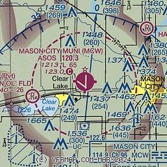
| Sectional chart |
|---|
|
 Download PDF
of official airport diagram from the FAA
| Airport distance calculator |
|---|
|
|
| Sunrise and sunset |
|---|
|
Times for 08-Apr-2025
| | Local
(UTC-5) | | Zulu
(UTC) |
|---|
| Morning civil twilight | | 06:15 | | 11:15 |
| Sunrise | | 06:44 | | 11:44 |
| Sunset | | 19:46 | | 00:46 |
| Evening civil twilight | | 20:16 | | 01:16 |
|
| Current date and time |
|---|
| Zulu (UTC) | 08-Apr-2025 22:09:23 |
|---|
| Local (UTC-5) | 08-Apr-2025 17:09:23 |
|---|
|
| METAR |
|---|
| KMCW | 082153Z AUTO 19009KT 10SM CLR 10/M11 A2999 RMK AO2 SLP162 T01001111
|
KFXY
14nm W | 082155Z AUTO 14007G15KT 10SM CLR 10/M12 A2999 RMK AO2
|
|
| TAF |
|---|
| KMCW | 081720Z 0818/0918 19009G17KT P6SM SKC FM090200 14007KT P6SM OVC250 FM091500 23007KT P6SM OVC050
|
|
| NOTAMs |
|---|
NOTAMs are issued by the DoD/FAA and will open in a separate window not controlled by AirNav.
|
|


