FAA INFORMATION EFFECTIVE 17 APRIL 2025
Location
| FAA Identifier: | MCX |
| Lat/Long: | 40-42-36.6980N 086-46-00.4580W
40-42.611633N 086-46.007633W
40.7101939,-86.7667939
(estimated) |
| Elevation: | 678.5 ft. / 206.8 m (surveyed) |
| Variation: | 03W (1995) |
| From city: | 3 miles S of MONTICELLO, IN |
| Time zone: | UTC -4 (UTC -5 during Standard Time) |
| Zip code: | 47960 |
Airport Operations
| Airport use: | Open to the public |
| Activation date: | 05/1954 |
| Control tower: | no |
| ARTCC: | CHICAGO CENTER |
| FSS: | TERRE HAUTE FLIGHT SERVICE STATION |
| NOTAMs facility: | HUF (NOTAM-D service available) |
| Attendance: | 0800-1600
ARPT UNATNDD ALL MAJOR HOLIDAYS. |
| Wind indicator: | lighted |
| Segmented circle: | no |
| Lights: | ACTVT REIL RWY 18/36; MIRL 18/36 - CTAF. |
| Beacon: | white-green (lighted land airport)
Operates sunset to sunrise. |
Airport Communications
| CTAF/UNICOM: | 122.8 |
| WX AWOS-3P: | 124.05 (574-583-0531) |
| GRISSOM APPROACH: | 123.85 |
| GRISSOM DEPARTURE: | 123.85 |
| WX AWOS-3P at GGP (18 nm E): | 118.5 (574-737-7310) |
| WX ASOS at LAF (19 nm SW): | PHONE 765-743-9687 |
- APCH/DEP SVC PRVDD BY CHICAGO ARTCC ON FREQ 123.85 (LAFAYETTE RCAG) WHEN GRISSOM (GUS) APCH/DEP CON CLSD.
Nearby radio navigation aids
| VOR radial/distance | | VOR name | | Freq | | Var |
|---|
| BVTr055/16.6 | | BOILER VORTAC | | 115.10 | | 01E |
| GUSr280/28.3 | | GRISSOM VORTAC | | 108.45 | | 02W |
Airport Services
| Fuel available: | 100LL JET-A
A:UNDERWING & OVERWING REFUELING AVAILABLE UPON REQUEST. SELF SVC AVBL 24 HRS.
100LL:SELF SVC AVBL 24 HRS. |
| Parking: | hangars and tiedowns |
| Airframe service: | MINOR |
| Powerplant service: | MINOR |
| Bottled oxygen: | NONE |
| Bulk oxygen: | NONE |
Runway Information
Runway 18/36
| Dimensions: | 5001 x 75 ft. / 1524 x 23 m |
| Surface: | asphalt/grooved, in excellent condition |
| Weight bearing capacity: | | PCN 9 /F/C/Y/T | | Single wheel: | 25.5 | | Double wheel: | 40.0 |
|
| Runway edge lights: | medium intensity |
| RUNWAY 18 | | RUNWAY 36 |
| Latitude: | 40-43.023298N | | 40-42.199980N |
| Longitude: | 086-46.019658W | | 086-45.995620W |
| Elevation: | 678.5 ft. | | 669.4 ft. |
| Traffic pattern: | left | | left |
| Runway heading: | 182 magnetic, 179 true | | 002 magnetic, 359 true |
| Markings: | nonprecision, in good condition | | nonprecision, in good condition |
| Visual slope indicator: | 2-light PAPI on left (3.00 degrees glide path)
UNUSBL BYD 8 DEGS RIGHT OF CNTRLN. | | 2-light PAPI on left (4.00 degrees glide path) |
| Runway end identifier lights: | yes | | yes |
| Touchdown point: | yes, no lights | | yes, no lights |
| Obstructions: | road, 20:1 slope to clear | | 60 ft. trees, 770 ft. from runway, 255 ft. left of centerline, 9:1 slope to clear |
Airport Ownership and Management from official FAA records
| Ownership: | Publicly-owned |
| Owner: | WHITE COUNTY BOAC
2222 AIRPORT RD
MONTICELLO, IN 47960
Phone 574-583-9900 |
| Manager: | DEREK SHANNON
2222 AIRPORT RD
MONTICELLO, IN 47960
Phone 574-583-9900 |
Additional Remarks
| - | TWY EDGE MARKED WITH 2 FT YELLOW CYLINDER REFLECTORS. |
| - | DEER INVOF ARPT. |
| - | FREQUENT AERIAL APPLICATION TFC DUR MONTHS OF JUN, JUL, AUG. |
| - | FOR CD CTC CHICAGO ARTCC AT 630-906-8921. |
Instrument Procedures
NOTE: All procedures below are presented as PDF files. If you need a reader for these files, you should download the free Adobe Reader.NOT FOR NAVIGATION. Please procure official charts for flight.
FAA instrument procedures published for use from 17 April 2025 at 0901Z to 15 May 2025 at 0900z.
IAPs - Instrument Approach Procedures |
|---|
| RNAV (GPS) RWY 18 | |
download (195KB) |
| RNAV (GPS) RWY 36 | |
download (201KB) |
| NOTE: Special Alternate Minimums apply | |
download (44KB) |
| NOTE: Special Take-Off Minimums/Departure Procedures apply | |
download (247KB) |
Other nearby airports with instrument procedures:
1I9 - Delphi Municipal Airport (11 nm S)
KGGP - Logansport/Cass County Airport (18 nm E)
KLAF - Purdue University Airport (19 nm SW)
KRZL - Jasper County Airport (24 nm NW)
KRWN - Arens Field Airport (24 nm N)
|
|

Road maps at:
MapQuest
Bing
Google
| Aerial photo |
|---|
WARNING: Photo may not be current or correct
 Photo taken 13-Aug-2006
Do you have a better or more recent aerial photo of White County Airport that you would like to share? If so, please send us your photo.
|
| Sectional chart |
|---|
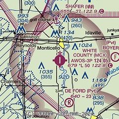
|
| Airport distance calculator |
|---|
|
|
| Sunrise and sunset |
|---|
|
Times for 23-Apr-2025
| | Local
(UTC-4) | | Zulu
(UTC) |
|---|
| Morning civil twilight | | 06:28 | | 10:28 |
| Sunrise | | 06:57 | | 10:57 |
| Sunset | | 20:33 | | 00:33 |
| Evening civil twilight | | 21:02 | | 01:02 |
|
| Current date and time |
|---|
| Zulu (UTC) | 23-Apr-2025 15:33:39 |
|---|
| Local (UTC-4) | 23-Apr-2025 11:33:39 |
|---|
|
| METAR |
|---|
| KMCX | 231515Z AUTO 00000KT 10SM CLR 20/10 A3020 RMK AO2 T02000096
|
KGGP
18nm E | 231515Z AUTO 00000KT 10SM CLR 20/10 A3021 RMK AO2
|
KLAF
19nm SW | 231454Z 05006KT 10SM CLR 20/11 A3019 RMK AO2 SLP222 T02000106 51004
|
|
| TAF |
|---|
KLAF
19nm SW | 231120Z 2312/2412 20003KT P6SM FEW250 FM231500 15006KT P6SM FEW250 FM240200 13002KT P6SM FEW250
|
|
| NOTAMs |
|---|
NOTAMs are issued by the DoD/FAA and will open in a separate window not controlled by AirNav.
|
|


