FAA INFORMATION EFFECTIVE 14 MAY 2026
Location
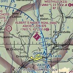
| FAA Identifier: | N66 |
| Lat/Long: | 42-31-29.2000N 075-03-52.1000W
42-31.486667N 075-03.868333W
42.5247778,-75.0644722
(estimated) |
| Elevation: | 1763.3 ft. / 537.5 m (surveyed) |
| Variation: | 13W (2010) |
| From city: | 3 miles N of ONEONTA, NY |
| Time zone: | UTC -4 (UTC -5 during Standard Time) |
| Zip code: | 13820 |
Airport Operations
| Airport use: | Open to the public |
| Control tower: | no |
| ARTCC: | BOSTON CENTER |
| FSS: | BUFFALO FLIGHT SERVICE STATION |
| NOTAMs facility: | BUF (NOTAM-D service available) |
| Attendance: | MON-FRI 0900-1700 |
| Wind indicator: | lighted |
| Segmented circle: | yes |
| Lights: | ACTVT MALS RWY 24; REIL 06/24; PAPI RWY 24; MIRL RWY 06/24 - CTAF. |
| Beacon: | white-green (lighted land airport)
BCN TWR PARTIALLY OBSCURED BY TREES. Operates sunset to sunrise. |
| Landing fee: | yes |
| International operations: | customs landing rights airport |
Airport Communications
| CTAF/UNICOM: | 122.8 |
| WX AWOS-3: | 119.575 (607-643-0253) |
- APCH/DEP SVC PRVDD BY BOSTON ARTCC ON FREQS 133.25/279.5 (ROCKDALE RCAG).
Nearby radio navigation aids
| VOR radial/distance | | VOR name | | Freq | | Var |
|---|
| RKAr077/8.5 | | ROCKDALE VOR/DME | | 112.60 | | 11W |
| DNYr358/21.3 | | DELANCEY VOR/DME | | 112.10 | | 11W |
| HNKr033/29.9 | | HANCOCK VOR/DME | | 116.80 | | 11W |
Airport Services
| Fuel available: | 100LL JET-A JET-A+ |
| Parking: | hangars and tiedowns |
| Airframe service: | MAJOR |
| Powerplant service: | MAJOR |
| Bottled oxygen: | NONE |
| Bulk oxygen: | NONE |
Runway Information
Runway 6/24
| Dimensions: | 4199 x 75 ft. / 1280 x 23 m |
| Surface: | asphalt, in excellent condition |
| Weight bearing capacity: | |
| Runway edge lights: | medium intensity |
| RUNWAY 6 | | RUNWAY 24 |
| Latitude: | 42-31.237882N | | 42-31.733815N |
| Longitude: | 075-04.193183W | | 075-03.542365W |
| Elevation: | 1762.8 ft. | | 1750.1 ft. |
| Traffic pattern: | left | | left |
| Runway heading: | 057 magnetic, 044 true | | 237 magnetic, 224 true |
| Markings: | nonprecision, in good condition | | nonprecision, in good condition |
| Visual slope indicator: | | | 2-light PAPI on left (3.00 degrees glide path) |
| Approach lights: | | | MALS: 1,400 foot medium intensity approach lighting system |
| Runway end identifier lights: | yes | | yes
RWY 24 REILS OTS |
| Touchdown point: | yes, no lights | | yes, no lights |
| Instrument approach: | | | LOCALIZER |
| Obstructions: | 68 ft. tree, 818 ft. from runway, 315 ft. right of centerline, 9:1 slope to clear
7 FT BERM 150 FT RIGHT AND PARALLEL TO RY 6 PRIMARY SURFACE. | | 121 ft. fence, marked, 2442 ft. from runway, 518 ft. left of centerline, 18:1 slope to clear |
Airport Ownership and Management from official FAA records
| Ownership: | Publicly-owned |
| Owner: | CITY OF ONEONTA
258 MAIN STREET
ONEONTA, NY 13820
Phone 607-431-1076 |
| Manager: | KERRIANN HARRINGTON
391 AIRPORT RD
ONEONTA, NY 13820
Phone (607) 431-1076 |
Additional Remarks
| - | FOR CD CTC BOSTON ARTCC AT 603-879-6859. |
| E94 | SAWRS |
Instrument Procedures
NOTE: All procedures below are presented as PDF files. If you need a reader for these files, you should download the free Adobe Reader.NOT FOR NAVIGATION. Please procure official charts for flight.
FAA instrument procedures published for use from 14 May 2026 at 0901Z to 11 June 2026 at 0900Z.
IAPs - Instrument Approach Procedures |
|---|
| RNAV (GPS) RWY 06 | |
download (240KB) |
| RNAV (GPS) RWY 24 | |
download (246KB) |
| NOTE: Special Take-Off Minimums/Departure Procedures apply | |
download (525KB) |
Other nearby airports with instrument procedures:
KOIC - LT Warren Eaton Airport (20 nm W)
N23 - Sidney Municipal Airport (20 nm SW)
KVGC - Hamilton Municipal Airport (29 nm NW)
NY0 - Fulton County Airport (43 nm NE)
KBGM - Greater Binghamton Airport/Edwin A Link Field (45 nm SW)
|
|

Road maps at:
MapQuest
Bing
Google
| Aerial photo |
|---|
WARNING: Photo may not be current or correct
 Photo taken 12-Oct-2008
Do you have a better or more recent aerial photo of Albert S Nader Regional Airport that you would like to share? If so, please send us your photo.
|
| Sectional chart |
|---|
|
| Airport distance calculator |
|---|
|
|
| Sunrise and sunset |
|---|
|
Times for 16-May-2026
| | Local
(UTC-4) | | Zulu
(UTC) |
|---|
| Morning civil twilight | | 05:06 | | 09:06 |
| Sunrise | | 05:38 | | 09:38 |
| Sunset | | 20:15 | | 00:15 |
| Evening civil twilight | | 20:47 | | 00:47 |
|
| Current date and time |
|---|
| Zulu (UTC) | 16-May-2026 18:41:29 |
|---|
| Local (UTC-4) | 16-May-2026 14:41:29 |
|---|
|
| METAR |
|---|
KOIC
20nm W | 161815Z AUTO 19012G22KT 10SM CLR 23/07 A2991 RMK AO2
|
KVGC
29nm NW | 161815Z AUTO 16012G18KT 10SM CLR 22/05 A2991 RMK AO2
|
|
| TAF |
|---|
KRME
44nm N | 161120Z 1612/1712 00000KT P6SM FEW250 FM161600 22008G20KT P6SM BKN090 FM162200 23007KT P6SM BKN050 FM170100 24007KT P6SM BKN025 FM170300 25008KT 6SM -SHRA BKN015 FM170500 30006KT P6SM BKN015
|
KBGM
45nm SW | 161720Z 1618/1718 24010G20KT P6SM SKC FM162300 24008KT P6SM BKN050 TEMPO 1700/1702 6SM -SHRA BR FM170400 24005KT P6SM BKN030 TEMPO 1709/1712 BKN015 FM171200 26006KT P6SM SCT020 FM171500 29007G13KT P6SM FEW080
|
|
| NOTAMs |
|---|
NOTAMs are issued by the DoD/FAA and will open in a separate window not controlled by AirNav.
|
|

