FAA INFORMATION EFFECTIVE 16 APRIL 2026
Location
| FAA Identifier: | O37 |
| Lat/Long: | 39-43-13.4000N 122-08-46.9000W
39-43.223333N 122-08.781667W
39.7203889,-122.1463611
(estimated) |
| Elevation: | 217.7 ft. / 66.4 m (surveyed) |
| Variation: | 14E (2020) |
| From city: | 3 miles SE of ORLAND, CA |
| Time zone: | UTC -7 (UTC -8 during Standard Time) |
| Zip code: | 95963 |
Airport Operations
| Airport use: | Open to the public |
| Activation date: | 09/1947 |
| Control tower: | no |
| ARTCC: | OAKLAND CENTER |
| FSS: | RANCHO MURIETA FLIGHT SERVICE STATION |
| NOTAMs facility: | RIU (NOTAM-D service available) |
| Attendance: | MON-FRI 0700-1530 |
| Wind indicator: | lighted |
| Segmented circle: | yes |
| Lights: | ACTVT MIRL RWY 15/33 - CTAF. |
| Beacon: | white-green (lighted land airport)
Operates sunset to sunrise. |
Airport Communications
| CTAF/UNICOM: | 122.7 |
| WX AWOS-3 at CIC (14 nm E): | 119.675 (530-879-3850) |
- APCH/DEP CTL SVC PRVDD BY OAKLAND ARTCC (ZOA) ON FREQS 132.2/350.3 (RED BLUFF RCAG).
Nearby radio navigation aids
| VOR radial/distance | | VOR name | | Freq | | Var |
|---|
| RBLr152/23.1 | | RED BLUFF VORTAC | | 115.70 | | 18E |
| ILAr334/39.3 | | WILLIAMS VORTAC | | 114.40 | | 18E |
Airport Services
| Fuel available: | 100LL |
| Parking: | tiedowns |
| Airframe service: | MAJOR |
| Powerplant service: | MAJOR |
| Bottled oxygen: | NONE |
| Bulk oxygen: | NONE |
Runway Information
Runway 15/33
| Dimensions: | 4500 x 60 ft. / 1372 x 18 m |
| Surface: | asphalt, in good condition |
| Weight bearing capacity: | |
| Runway edge lights: | medium intensity |
| RUNWAY 15 | | RUNWAY 33 |
| Latitude: | 39-43.582383N | | 39-42.864410N |
| Longitude: | 122-08.901452W | | 122-08.663015W |
| Elevation: | 217.7 ft. | | 209.7 ft. |
| Traffic pattern: | left | | left |
| Runway heading: | 152 magnetic, 166 true | | 332 magnetic, 346 true |
| Markings: | basic, in fair condition | | basic, in fair condition |
| Visual slope indicator: | 2-light PAPI on left (3.50 degrees glide path) | | 2-light PAPI on left (3.50 degrees glide path) |
| Runway end identifier lights: | no | | no |
| Touchdown point: | yes, no lights | | yes, no lights |
| Obstructions: | 15 ft. road, 700 ft. from runway, 125 ft. left of centerline, 33:1 slope to clear | | 30 ft. pole, 1200 ft. from runway, 125 ft. left of centerline, 33:1 slope to clear |
Airport Ownership and Management from official FAA records
| Ownership: | Publicly-owned |
| Owner: | GLENN COUNTY
777 N. COLUSA STREET
WILLOWS, CA 95988
Phone 530-934-6400 |
| Manager: | DONALD RUST
PO BOX 1070
WILLOWS, CA 95988
Phone 530-934-6530
OFFICE AT ORLAND ARPT PHONE 530-624-0836. |
Additional Remarks
| A96 | ULTRALIGHT ACTIVITY ON & INVOF ARPT. |
| - | FOR CD CTC OAKLAND ARTCC AT 510-745-3380. |
Instrument Procedures
NOTE: All procedures below are presented as PDF files. If you need a reader for these files, you should download the free Adobe Reader.NOT FOR NAVIGATION. Please procure official charts for flight.
FAA instrument procedures published for use from 16 April 2026 at 0901Z to 14 May 2026 at 0900Z.
IAPs - Instrument Approach Procedures |
|---|
| RNAV (GPS)-A | |
download (169KB) |
| NOTE: Special Take-Off Minimums/Departure Procedures apply | |
download (347KB) |
Other nearby airports with instrument procedures:
KWLW - Willows/Glenn County Airport (13 nm S)
KCIC - Chico Regional Airport (14 nm E)
KRBL - Red Bluff Municipal Airport (26 nm N)
KOVE - Oroville Municipal Airport (28 nm SE)
O08 - Colusa County Airport (33 nm S)
|
|

Road maps at:
MapQuest
Bing
Google
| Aerial photo |
|---|
WARNING: Photo may not be current or correct

Do you have a better or more recent aerial photo of Haigh Field Airport that you would like to share? If so, please send us your photo.
|
| Sectional chart |
|---|
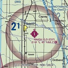
|
| Airport distance calculator |
|---|
|
|
| Sunrise and sunset |
|---|
|
Times for 10-May-2026
| | Local
(UTC-7) | | Zulu
(UTC) |
|---|
| Morning civil twilight | | 05:30 | | 12:30 |
| Sunrise | | 06:00 | | 13:00 |
| Sunset | | 20:10 | | 03:10 |
| Evening civil twilight | | 20:40 | | 03:40 |
|
| Current date and time |
|---|
| Zulu (UTC) | 10-May-2026 07:17:03 |
|---|
| Local (UTC-7) | 10-May-2026 00:17:03 |
|---|
|
| METAR |
|---|
KCIC
15nm E | 100152Z 20005KT 10SM CLR 33/15 A2980
|
KRBL
26nm N | 100654Z AUTO 00000KT 10SM CLR 21/17 A2987 RMK AO2 SLP111 T02110167
|
KOVE
28nm SE | 100653Z AUTO 12006KT 10SM CLR 22/16 A2987 RMK AO2 SLP116 T02220161
|
|
| TAF |
|---|
KRBL
26nm N | 100520Z 1006/1106 VRB05KT P6SM SKC FM101900 VRB05KT P6SM FEW250
|
|
| NOTAMs |
|---|
NOTAMs are issued by the DoD/FAA and will open in a separate window not controlled by AirNav.
|
|

