FAA INFORMATION EFFECTIVE 11 JUNE 2026
Location
| FAA Identifier: | ONO |
| Lat/Long: | 44-01-09.7000N 117-00-46.9000W
44-01.161667N 117-00.781667W
44.0193611,-117.0130278
(estimated) |
| Elevation: | 2193.3 ft. / 668.5 m (surveyed) |
| Variation: | 13E (2020) |
| From city: | 3 miles W of ONTARIO, OR |
| Time zone: | UTC -7 (UTC -8 during Standard Time) |
| Zip code: | 97914 |
Airport Operations
| Airport use: | Open to the public |
| Activation date: | 05/1947 |
| Control tower: | no |
| ARTCC: | SALT LAKE CITY CENTER |
| FSS: | MC MINNVILLE FLIGHT SERVICE STATION |
| NOTAMs facility: | ONO (NOTAM-D service available) |
| Attendance: | NOV-MAR M-F 0900-1500, APR-OCT 0800-1700
WINTER HRS.
SUMMER HRS. |
| Wind indicator: | lighted |
| Segmented circle: | no |
| Lights: | ACTVT REIL RWY 15 & 33; MIRL RWY 15/33 - CTAF. PAPI RWY 15 & 33 OPER CONT. |
| Beacon: | white-green (lighted land airport)
Operates sunset to sunrise. |
Airport Communications
| CTAF/UNICOM: | 122.8 |
| WX ASOS: | 135.275 (541-889-7388) |
- APCH/DEP CTL SVC PRVDD BY SALT LAKE ARTCC (ZLC) ON FREQS 128.05/306.95 (BAKER RCAG).
- COMMUNICATIONS PRVDD BY MC MINNVILLE FSS ON FREQ 122.3 (ONTARIO RCO).
Airport Services
| Fuel available: | 100LL JET-A
A:SELF-SERVE CARD LOCK FUEL AVBL 24 HRS. FULL SVC A/HRS SURCHARGE APPLIES. CALL SILVERHAWK FBO 541-889-9197, A/HRS 208-453-8577 FOR ANY QNX/CONCERNS.
100LL:SELF SERVE CARD LOCK FUEL AVAIL. 24 HRS. |
| Parking: | tiedowns |
| Airframe service: | MAJOR |
| Powerplant service: | MAJOR |
| Bottled oxygen: | NONE |
Runway Information
Runway 15/33
| Dimensions: | 5006 x 100 ft. / 1526 x 30 m |
| Surface: | asphalt, in fair condition |
| Weight bearing capacity: | | Single wheel: | 30.0 | | Double wheel: | 60.0 |
|
| Runway edge lights: | medium intensity |
| RUNWAY 15 | | RUNWAY 33 |
| Latitude: | 44-01.544650N | | 44-00.777638N |
| Longitude: | 117-00.989242W | | 117-00.572510W |
| Elevation: | 2193.1 ft. | | 2188.8 ft. |
| Traffic pattern: | left | | left |
| Runway heading: | 145 magnetic, 158 true | | 325 magnetic, 338 true |
| Markings: | nonprecision, in good condition | | nonprecision, in good condition |
| Visual slope indicator: | 2-light PAPI on left (3.00 degrees glide path) | | 2-light PAPI on left (3.00 degrees glide path) |
| Runway end identifier lights: | yes | | yes |
| Touchdown point: | yes, no lights | | yes, no lights |
| Obstructions: | 10 ft. road, 380 ft. from runway, 18:1 slope to clear | | none |
Airport Ownership and Management from official FAA records
| Ownership: | Publicly-owned |
| Owner: | CITY OF ONTARIO
444 SW 4TH ST
ONTARIO, OR 97914
Phone 541-889-7684 |
| Manager: | ANDY WOOD
581 SW 33RD ST.
ONTARIO, OR 97914
Phone 541-709-7651
541-709-7651 CELL. |
Additional Remarks
| - | GLDR OPS SFC5000 FT WI AN AREA DEFINED AS 3NM RADIUS OF ONO. APR-OCT AVOIDANCE ADZ WED-SUN 18000000Z (WX PMTG). NOTAMS WILL BE ISSUED WHEN ACTV. CALL GLDR INFO & COMMS OFFICER AT (208) 444-7310 FOR ANY QNS/CONCERNS. |
| - | FOR CD CTC SALT LAKE ARTCC AT 801-320-2568. |
| - | HELI LNDG ON HELI PRKG PAD, FUEL FARM, HELI OVERFLOW PRKG CORPORATE APN & OLD CROSSWIND RWY NEAR SEGMENTED WINDSOCK. GA APN CLSD TO HELI LNDG. CALL SILVERHAWK FBO AT (541) 889-9197, A/HRS (208) 453-8577 FOR ANY QNS/CONCERNS. |
| - | FIRE FIXED WING ACFT RESD PRKG GA TWY TIE DOWNS 19/34, AND CORPORATE APRON TWY TIE DOWN E2-E3. JUN-OCT AVOIDANCE ADZ. CALL SILVERHAWK FBO AT (541) 889-9197, A/HRS (208) 453-8577 FOR ANY QNS/CONCERNS. |
| - | 2 COURTESY CARS AVBL BY RESV, CALL SILVERHAWK FBO AT (541) 889-9197, A/HRS (208) 453-8577 FOR ANY QNS/CONCERNS. |
Instrument Procedures
NOTE: All procedures below are presented as PDF files. If you need a reader for these files, you should download the free Adobe Reader.NOT FOR NAVIGATION. Please procure official charts for flight.
FAA instrument procedures published for use from 11 June 2026 at 0901Z to 09 July 2026 at 0900z.
IAPs - Instrument Approach Procedures |
|---|
| RNAV (GPS) RWY 15 | |
download (232KB) |
| RNAV (GPS) RWY 33 | |
download (241KB) |
| NOTE: Special Alternate Minimums apply | |
download (87KB) |
| NOTE: Special Take-Off Minimums/Departure Procedures apply | |
download (422KB) |
Other nearby airports with instrument procedures:
S87 - Weiser Municipal Airport (11 nm N)
KEUL - Caldwell Executive Airport (28 nm SE)
KMAN - Nampa Municipal Airport (34 nm SE)
KBOI - Boise Air Terminal/Gowen Field (44 nm SE)
KBKE - Baker City Municipal Airport (60 nm NW)
|
|

Road maps at:
MapQuest
Bing
Google
| Aerial photo |
|---|
WARNING: Photo may not be current or correct
 Photo taken 08-Aug-2017
looking northwest.
Photo taken 08-Aug-2017
looking northwest.
Do you have a better or more recent aerial photo of Ontario Municipal Airport that you would like to share? If so, please send us your photo.
|
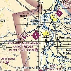
| Sectional chart |
|---|
|
| Airport distance calculator |
|---|
|
|
| Sunrise and sunset |
|---|
|
Times for 14-Jun-2026
| | Local
(UTC-7) | | Zulu
(UTC) |
|---|
| Morning civil twilight | | 04:29 | | 11:29 |
| Sunrise | | 05:05 | | 12:05 |
| Sunset | | 20:31 | | 03:31 |
| Evening civil twilight | | 21:07 | | 04:07 |
|
| Current date and time |
|---|
| Zulu (UTC) | 14-Jun-2026 10:50:10 |
|---|
| Local (UTC-7) | 14-Jun-2026 03:50:10 |
|---|
|
| METAR |
|---|
| KONO | 140953Z AUTO 20003KT 10SM CLR 16/02 A3009 RMK AO2 SLP177 T01560022
|
|
| TAF |
|---|
| KONO | 140520Z 1406/1506 34010KT P6SM SKC FM141400 VRB04KT P6SM SKC FM142100 35008KT P6SM SKC
|
|
| NOTAMs |
|---|
NOTAMs are issued by the DoD/FAA and will open in a separate window not controlled by AirNav.
|
|


